METAR & TAF KINW
Current METAR
Observed 12:56Z
KINW 271256Z AUTO 00000KT 10SM CLR 22/14 A3017 RMK AO2 SLP130 T02170139
- Wind
- 000° @ 0 kt
- Visibility
- 10 SM
- Temp / Dew
- 22°C / 14°C
- Altimeter
- 30.17 inHg
- Clouds
- CLR
- Density alt
- 6,657 ft
- Ceiling
- Unlimited
- Rules
- VFR
Airport info & contacts
Manager on record, flight service, ARTCC, attendance schedule and pattern altitude — published by the FAA and refreshed every 28 days.
Location
- From city
- 1 NM W
- VFR sectional
- PHOENIX
- ARTCC
- ZAB · ALBUQUERQUE
- NOTAM facility
- INW (NOTAM-D)
Airport manager
- Name
- TIM WESTOVER
- Phone
- 928-289-2422
- Address
- 21 WILLIAMSON AVE, WINSLOW AZ 86047
Flight service · Hours
- FSS PRC
- PRESCOTT1-800-WX-BRIEF
- Attendance
- MON-FRI · 0700-1800
- SAT-SUN · 0800-1700
Frequencies
Tap any row to copy the frequency to your clipboard.
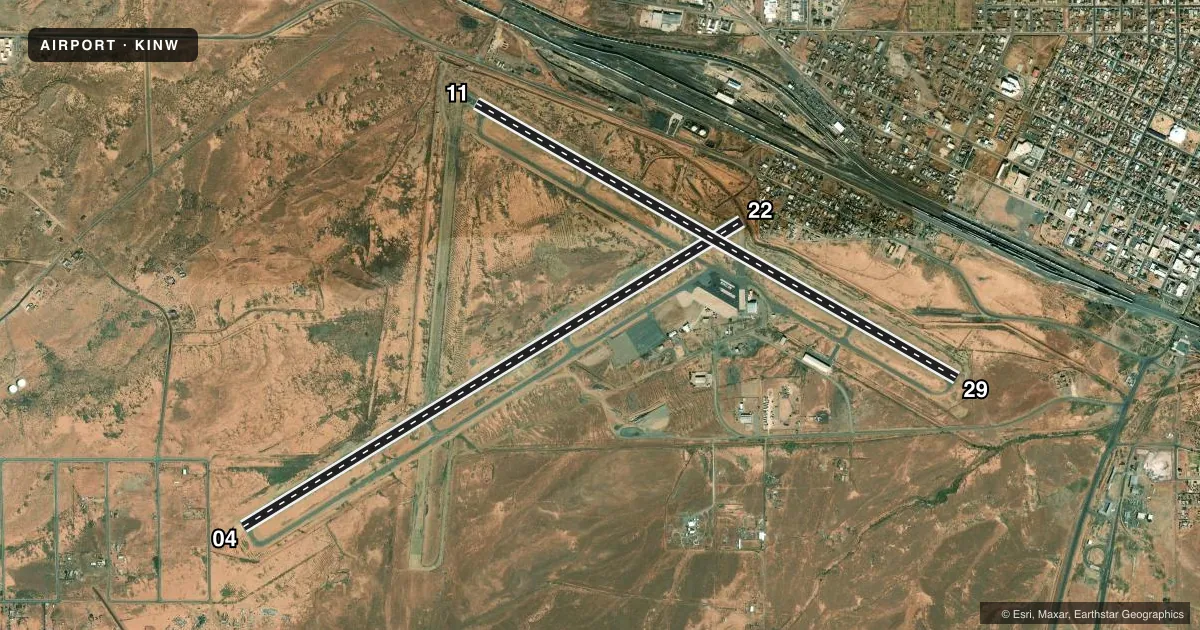
Runways & pattern
Full pagePattern entry · RWY 04
LEFT TRAFFIC| Runway | Heading (°M) | Length | Surface | Traffic |
|---|---|---|---|---|
| 04/22 | 45° / 225° | 7,499 ft | ASPH | Standard L |
| 11/29 | 106° / 286° | 7,100 ft | ASPH | 11 R |
Runway end performance
| End | TORA | TODA | ASDA | LDA | VGSI | Approach lights | Obstruction |
|---|---|---|---|---|---|---|---|
| 04 | — | — | — | 7,499' | — | — | — |
| 22 | — | — | — | 6,236' | VASI 4-box left(3°) | — | 18', tree, 219' from thr, 0' R of cntrln, slope 1 |
| 11 | — | — | — | 7,100' | VASI 4-box left(3°) | — | — |
| 29 | — | — | — | 6,756' | VASI 4-box left(3°) | — | 8', fence, 201' from thr, 75' R of cntrln, slope 0 |
Declared distances in feet. TORA = takeoff run available, TODA = takeoff distance, ASDA = accelerate-stop, LDA = landing distance.
Airport sketch
Runways drawn to scale from FAA survey coordinates, rendered over satellite imagery. Not for navigation.
Approaches & charts
Services on the field
Fuel grades, oxygen, maintenance, ramp storage and lighting — as declared to the FAA by the airport operator.
Fuel & services
- Fuel
- 100LLA
- Other services
- AMB
Ramp & ground
- Transient storage
- Tie-down
- Hangar
- Landing fee
- No fee published
- Customs
- Not available
- Lighting schedule
- SEE RMK
- Beacon schedule
- SS-SR
- Beacon
- White / Green (civil land)(WG)
- Wind indicator
- Lighted
- Segmented circle
- Yes
Fuel & FBOs
Cheapest 100LL and Jet A on the field and nearby. Always confirm with the FBO before taxi.
Airport notes
Surface conditions, obstructions, local procedures, lighting outages and other notes published with each FAA cycle.
General notes
- SW CORNER FOREST SVC RAMP CLSD.
- FOR CD IF UNA TO CTC ON FSS FREQ, CTC ALBUQUERQUE ARTCC AT 505-856-4561.
Lighting notes
- ACTVT REIL RWY 11 & 22; MIRL RWY 04/22 & 11/29 - CTAF. VASI RWY 11 & 29 OPR CONSLY.
Approach & departure obstructions
- 11+4 FT BRUSH 0-200 FT FM THR 75-250 FT L & R OF CNTRLN.
- 2215 FT DITCH 15 FT FM RWY END ACRS THR. +12 FT TREES 10 FT FM THR 80 FT L OF CNTRLN.
- 298 FT FENCE 200 FT FM RWY END ACRS THR. 3 FT BRUSH 0-200 FT FM RWY END ACRS THR.
- 11FADED.
- 29FADED.
- 22APCH RATIO 50:1 TO DTHR.
Other notes
- ESTABD PRIOR TO 1959.
- COML LNDG & OVNGT TIEDOWN FEE.
- SEGMETED CIRCLE MISSING RWY 11 R TFC ARMS.
- 2AFT HR SVC - 928-587-2630.
- MANAGERORVILLE WISEMAN - 928-289-0100.
- 11/29EDGES BOTH SIDES ROUGH WITH CRACKS & VEGETATION; CENTER PTN HAS LRG CRACKS & 4 IN HOLES.
VFR map & nearby airports
VFR sectional. Tap any ICAO chip to open that airport.
Key facts · KINW
Answer card- ICAO
- KINW
- Name
- WINSLOW-LINDBERGH RGNL
- Location
- WINSLOW, ARIZONA
- Elevation
- 4,941.1 ft MSL
- Traffic pattern altitude
- 5,941.1 ft MSL (1,000 AGL)
- Control tower
- Non-towered (use CTAF)
- Total runways
- 2
- Longest runway
- 04/22 · 7,499 ft
- Published ILS approaches
- 0
- Published frequencies
- 2
- Magnetic variation
- 14°
- Current flight rules
- VFR
- Current wind
- 000° at 0 kt
- Favored runway now
- –
KINW is in Winslow, Arizona. The field elevation is 4,941.1 ft MSL. It has two asphalt runways. The longest is 7,499 ft on runway 04/22. This is a non-towered airport. CTAF and UNICOM are both 122.8. No ILS approaches are published here.
Pattern altitude is not published in the facts. Use the standard 1,000 ft AGL for light piston unless the current FAA Chart Supplement says otherwise. That puts the light piston pattern at about 5,941 ft MSL. Wiseman Aviation is on the field. It carries 100LL, Jet A and Jet A Prist. Call (928) 289-0100 for current service details.
This is a high-elevation airport, so density altitude matters. Expect performance planning to matter more than it does at lower fields. The published remarks also show runway lighting is pilot-activated on 04/22 and 11/29. REIL is available on 11 and 22. VASI on 11 and 29 runs continuously. There are also published obstructions near runway 22 and runway 29. Runway 11 and runway 29 markings are faded. Check the current FAA Chart Supplement before departure for any operational notes that could affect your arrival.