METAR & TAF P14
P14 does not publish a METAR.
Showing the nearest reporting station: KINW (WINSLOW-LINDBERGH RGNL) · 29.1 NM away. Conditions at P14 may differ.
METAR · KINW
Observed 02:56Z
KINW 270256Z AUTO 25013KT 10SM CLR 28/14 A3013 RMK AO2 PK WND 27027/0204 SLP118 T02830139 53002
- Wind
- 250° @ 13 kt
- Visibility
- 10 SM
- Temp / Dew
- 28°C / 14°C
- Altimeter
- 30.13 inHg
- Clouds
- CLR
- Density alt
- 7,824 ft
- Ceiling
- Unlimited
- Rules
- VFR
Airport info & contacts
Manager on record, flight service, ARTCC, attendance schedule and pattern altitude — published by the FAA and refreshed every 28 days.
Location
- From city
- 3 NM NE
- VFR sectional
- PHOENIX
- ARTCC
- ZAB · ALBUQUERQUE
- NOTAM facility
- PRC (NOTAM-D)
Airport manager
- Name
- TIM KELLY
- Phone
- 928-241-2438
- Address
- 465 1ST AVE, HOLBROOK AZ 86025
Flight service · Hours
- FSS PRC
- PRESCOTT1-800-WX-BRIEF
- Attendance
- Unattended
Frequencies
Tap any row to copy the frequency to your clipboard.
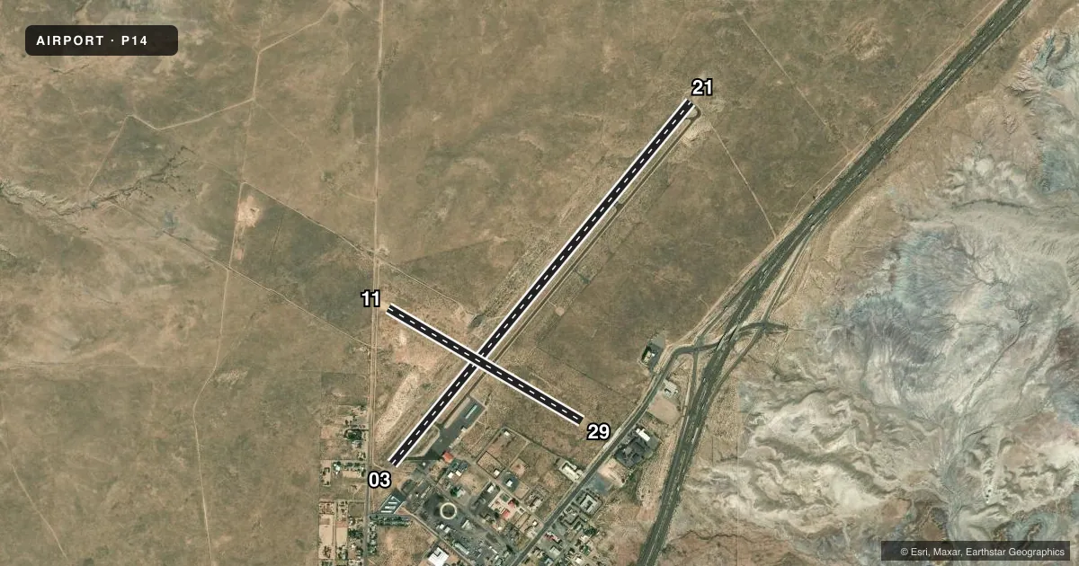
Runways & pattern
Full pagePattern entry · RWY 21
LEFT TRAFFIC| Runway | Heading (°M) | Length | Surface | Traffic |
|---|---|---|---|---|
| 03/21Favored | 27° / 207° | 6,698 ft | ASPH | Standard L |
| 11/29 | 108° / 288° | 3,202 ft | GRVL-DIRT | Standard L |
Runway end performance
| End | TORA | TODA | ASDA | LDA | VGSI | Approach lights | Obstruction |
|---|---|---|---|---|---|---|---|
| 03 | — | — | — | — | PAPI 2-box left(3°) | — | 15', road, 340' from thr, 140' R of cntrln, slope 7 |
| 21 | — | — | — | — | PAPI 2-box left(3°) | — | — |
| 11 | — | — | — | — | — | — | 10', road, 0' from thr, 0' R of cntrln, slope 0 |
| 29 | — | — | — | — | — | — | 40', pole, 400' from thr, 10' R of cntrln, slope 10 |
Declared distances in feet. TORA = takeoff run available, TODA = takeoff distance, ASDA = accelerate-stop, LDA = landing distance.
Airport sketch
Runways drawn to scale from FAA survey coordinates, rendered over satellite imagery. Not for navigation.
Approaches & charts
Services on the field
Fuel grades, oxygen, maintenance, ramp storage and lighting — as declared to the FAA by the airport operator.
Fuel & services
- Fuel
- 100LL
Ramp & ground
- Transient storage
- Tie-down
- Hangar
- Landing fee
- No fee published
- Customs
- Not available
- Lighting schedule
- SEE RMK
- Beacon schedule
- SS-SR
- Beacon
- White / Green (civil land)(WG)
- Wind indicator
- Lighted
- Segmented circle
- No
Fuel & FBOs
Cheapest 100LL and Jet A on the field and nearby. Always confirm with the FBO before taxi.
Airport notes
Surface conditions, obstructions, local procedures, lighting outages and other notes published with each FAA cycle.
General notes
- WILDLIFE ON OR INVOF ARPT.
- HELI S END OF RAMP.
Lighting notes
- ACTVT REIL RWY 03 & 21; PAPI RWY 03 & 21; MIRL RWY 03/21 - CTAF.
Fuel notes
- 100LLSELF SVC CREDIT CARD H24.
Approach & departure obstructions
- 03ROAD 104 FT FM RWY END; +2 FT BRUSH 0-200FT FM THR ACRS CNTRLN.
- 21+3 FT BRUSH 0-200 FT FM THR ACRS CNTRLN.
- 03APCH RATIO 57:1 TO DTHR.
Other notes
- ESTABD PRIOR TO 15 MAY 1959.
- AVBLTY - AMGR.
- 1FOR SVC MON-FRI 0800-1700 - AMGR OR 928-524-3991.
- 11/29SOFT DIRT; SFC COND - AMGR.
VFR map & nearby airports
VFR sectional. Tap any ICAO chip to open that airport.
Key facts · P14
Answer card- ICAO
- P14
- Name
- HOLBROOK MUNI
- Location
- HOLBROOK, ARIZONA
- Elevation
- 5,261.8 ft MSL
- Traffic pattern altitude
- 6,261.8 ft MSL (1,000 AGL)
- Control tower
- Non-towered (use CTAF)
- Total runways
- 2
- Longest runway
- 03/21 · 6,698 ft
- Published ILS approaches
- 0
- Published frequencies
- 2
- Magnetic variation
- 12°
- Current flight rules
- VFR
- Current wind
- 250° at 13 kt
- Favored runway now
- RWY 21
Holbrook Muni sits in Holbrook, Arizona at 5,261.8 ft MSL. It has two runways. The longest is 03/21 at 6,698 ft. Runway 11/29 is 3,202 ft with a soft dirt surface. There is no control tower. CTAF and UNICOM are both 122.8. No ILS approaches are published. Pattern altitude is not published, so use the standard 1,000 ft AGL for light piston traffic unless the current FAA Chart Supplement says otherwise.
The field is set up for high-desert flying. Expect density altitude to matter, especially on warm days. Wildlife is noted on or near the airport. Runway 03/21 has lights controlled by CTAF. Runway end identifier lights and PAPI are available on 03 and 21. The published remarks also note brush near the thresholds on 03 and 21. Runway 21 has brush across the centerline near the threshold. Runway 03 has a road near the end plus brush near the threshold. That makes a careful stabilized approach important.
Holbrook Municipal Airport is on the field and carries self-serve AVGAS 100LL. Fuel is available 24 hours with credit card. Helicopter ops are at the south end of the ramp. For weekday service from 0800 to 1700, contact the airport manager or call the number in the Chart Supplement.