METAR & TAF P10
P10 does not publish a METAR.
Showing the nearest reporting station: KINW (WINSLOW-LINDBERGH RGNL) · 48.5 NM away. Conditions at P10 may differ.
METAR · KINW
Observed 23:56Z
KINW 262356Z AUTO 27019G29KT 10SM FEW110 33/13 A3013 RMK AO2 PK WND 26030/2344 SLP115 T03280133 10356 20294 55008
- Wind
- 270° @ 19G29 kt
- Visibility
- 10 SM
- Temp / Dew
- 33°C / 13°C
- Altimeter
- 30.13 inHg
- Clouds
- FEW
- Density alt
- 8,810 ft
- Ceiling
- Unlimited
- Rules
- VFR
Airport info & contacts
Manager on record, flight service, ARTCC, attendance schedule and pattern altitude — published by the FAA and refreshed every 28 days.
Location
- From city
- 3 NM SW
- VFR sectional
- DENVER
- Pattern altitude
- 825 ft AGL · 6,398 ft MSL
- ARTCC
- ZDV · DENVER
- NOTAM facility
- PRC (NOTAM-D)
Airport manager
- Name
- TIMOTHY NUVANGYAPMA
- Phone
- 928-734-3101
- Address
- HOPI TRIBE PO BOX 123, PO BOX 158, KYKOTSMOVI AZ 86039
Flight service · Hours
- FSS PRC
- PRESCOTT1-800-WX-BRIEF
- Attendance
- Unattended
Frequencies
Tap any row to copy the frequency to your clipboard.
Runways & pattern
Full pagePattern entry · RWY 22
LEFT TRAFFICRunway end performance
| End | TORA | TODA | ASDA | LDA | VGSI | Approach lights | Obstruction |
|---|---|---|---|---|---|---|---|
| 04 | — | — | — | — | — | — | 4', brush, 201' from thr, 0' R of cntrln, slope 0 |
| 22 | — | — | — | — | — | — | 5', brush, 201' from thr, 0' R of cntrln, slope 0 |
Declared distances in feet. TORA = takeoff run available, TODA = takeoff distance, ASDA = accelerate-stop, LDA = landing distance.
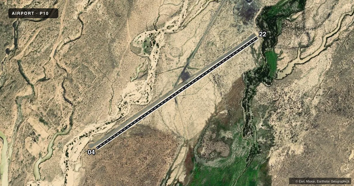
Airport sketch
Runways drawn to scale from FAA survey coordinates, rendered over satellite imagery. Not for navigation.
Approaches & charts
Services on the field
Fuel grades, oxygen, maintenance, ramp storage and lighting — as declared to the FAA by the airport operator.
Fuel & services
- Fuel
- Not available
Ramp & ground
- Transient storage
- Not published
- Landing fee
- No fee published
- Customs
- Not available
- Wind indicator
- No
- Segmented circle
- No
Fuel & FBOs
Cheapest 100LL and Jet A on the field and nearby. Always confirm with the FBO before taxi.
Airport notes
Surface conditions, obstructions, local procedures, lighting outages and other notes published with each FAA cycle.
General notes
- WASH IN RWY SAFETY ZONE.
- UNDERLIES MIL OPS AREA; BE AWARE OF RSTRNS & NOTAMS BFR OPS.
- PRKG RAMP HAS BLUE PERIMETER LGTS.
- FOR CD CTC DENVER ARTCC AT 303-651-4257.
Runway surface & condition
- 04/221-5 FT BRUSH 45 FT FM CNTRLN BOTH SIDES FULL LEN; ROAD XS RWY.
Approach & departure obstructions
- 04+4 FT FENCE 100 FT FM RWY END BOTH SIDES; +4 FT FENCE AT THR 100 FT L OF CNTRLN.
- 22+4 FT FENCE 100 FT FM RWY END BOTH SIDES; +5 FT BRUSH 50-200 FT FM THR ACRS APCH.
- 04CNTRLN FADED.
- 22CNTRLN FADED.
- 04CTLG OBS EXCEEDS 45 DEG SLOPE.
Other notes
- 04/22ROUGH, LRG CRACKS, HOLES, PATCHES & 8-10 IN ROCKS. HIGH GRASS & WEEDS IN CRACKS.
VFR map & nearby airports
VFR sectional. Tap any ICAO chip to open that airport.
Key facts · P10
Answer card- ICAO
- P10
- Name
- POLACCA
- Location
- POLACCA, ARIZONA
- Elevation
- 5,573 ft MSL
- Traffic pattern altitude
- 6,398 ft MSL (825 AGL)
- Control tower
- Non-towered (use CTAF)
- Total runways
- 1
- Longest runway
- 04/22 · 4,200 ft
- Published ILS approaches
- 0
- Published frequencies
- 1
- Magnetic variation
- 13°
- Current flight rules
- VFR
- Current wind
- 270° at 19 kt
- Favored runway now
- RWY 22
Polacca Airport sits in Polacca, Arizona at 5,573 ft MSL. It has one runway, 04/22, which is 4,200 ft long on asphalt. There is no control tower. CTAF is 122.9. No ILS approaches are published here.
The pattern altitude is 825 ft AGL, which puts it at 6,398 ft MSL. That matters here because the field is already high elevation. Expect performance to reflect the altitude. The airport also underlies a military operations area. Check NOTAMs and current restrictions before you go.
The runway surface is reported rough, with large cracks, holes, patches and 8 to 10 inch rocks. Brush lines both sides of the runway. There is also wash in the runway safety zone. The centerline is faded on both runway directions. A road crosses the runway. Published remarks also note fences near the runway ends and an obstruction issue near runway 04. Plan a careful inspection on arrival and on departure.
No on-field FBOs are listed. If you need current fuel or ground support, contact the airport operator directly or call the field on CTAF before arrival. The parking ramp has blue perimeter lights. For clearance delivery, contact Denver ARTCC at 303-651-4257.