METAR & TAF T03
T03 does not publish a METAR.
Showing the nearest reporting station: KGCN (GRAND CANYON NTL PARK) · 38.0 NM away. Conditions at T03 may differ.
METAR · KGCN
Observed 04:54Z
KGCN 260454Z AUTO 00000KT 10SM CLR 23/11 A3034 RMK AO2 SLP143 T02280106
- Wind
- 000° @ 0 kt
- Visibility
- 10 SM
- Temp / Dew
- 23°C / 11°C
- Altimeter
- 30.34 inHg
- Clouds
- CLR
- Density alt
- 6,035 ft
- Ceiling
- Unlimited
- Rules
- VFR
Airport info & contacts
Manager on record, flight service, ARTCC, attendance schedule and pattern altitude — published by the FAA and refreshed every 28 days.
Location
- From city
- 5 NM W
- VFR sectional
- LAS VEGAS
- ARTCC
- ZDV · DENVER
- NOTAM facility
- PRC (NOTAM-D)
Airport manager
- Name
- KYRON HARDY
- Phone
- 505-371-8323
- Address
- PO BOX 4620, WINDOW ROCK AZ 86515
Flight service · Hours
- FSS PRC
- PRESCOTT1-800-WX-BRIEF
- Attendance
- Unattended
Frequencies
Tap any row to copy the frequency to your clipboard.
Runways & pattern
Full pagePattern entry · RWY 15
LEFT TRAFFICRunway end performance
| End | TORA | TODA | ASDA | LDA | VGSI | Approach lights | Obstruction |
|---|---|---|---|---|---|---|---|
| 15 | — | — | — | — | PAPI 2-box left(3°) | — | — |
| 33 | — | — | — | — | PAPI 2-box left(3°) | — | — |
Declared distances in feet. TORA = takeoff run available, TODA = takeoff distance, ASDA = accelerate-stop, LDA = landing distance.
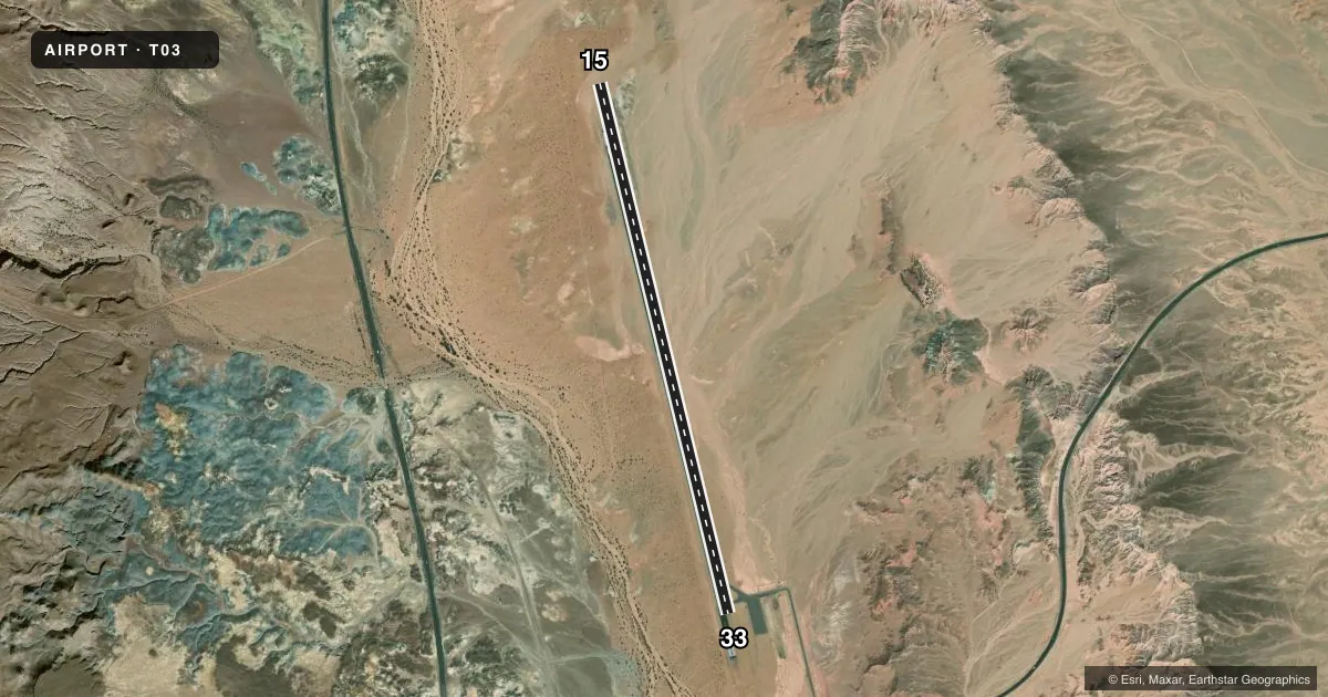
Airport sketch
Runways drawn to scale from FAA survey coordinates, rendered over satellite imagery. Not for navigation.
Approaches & charts
Services on the field
Fuel grades, oxygen, maintenance, ramp storage and lighting — as declared to the FAA by the airport operator.
Fuel & services
- Fuel
- Not available
Ramp & ground
- Transient storage
- Tie-down
- Landing fee
- No fee published
- Lighting schedule
- SEE RMK
- Beacon schedule
- SS-SR
- Beacon
- White / Green (civil land)(WG)
- Wind indicator
- Lighted
- Segmented circle
- Yes
Fuel & FBOs
Cheapest 100LL and Jet A on the field and nearby. Always confirm with the FBO before taxi.
Airport notes
Surface conditions, obstructions, local procedures, lighting outages and other notes published with each FAA cycle.
General notes
- LIVESTOCK ON ARPT.
- ARPT ACES - INDIAN HEALTH SVCS 928-283-2501.
Lighting notes
- ACTVT PAPI RWY 15 & 33; MIRL RWY 15/33 - CTAF.
Other notes
- MANAGER928-797-1684.
- 15/33N 1500 FT HAS +10 IN UNDULATIONS.
VFR map & nearby airports
VFR sectional. Tap any ICAO chip to open that airport.
Key facts · T03
Answer card- ICAO
- T03
- Name
- TUBA CITY
- Location
- TUBA CITY, ARIZONA
- Elevation
- 4,513 ft MSL
- Traffic pattern altitude
- 5,513 ft MSL (1,000 AGL)
- Control tower
- Non-towered (use CTAF)
- Total runways
- 1
- Longest runway
- 15/33 · 6,230 ft
- Published ILS approaches
- 0
- Published frequencies
- 1
- Magnetic variation
- 13°
- Current flight rules
- VFR
- Current wind
- 000° at 0 kt
- Favored runway now
- –
Tuba City Airport sits in Tuba City, Arizona. Field elevation is 4,513 ft MSL. The airport has one runway. Runway 15/33 is 6,230 ft long with an asphalt surface. There is no control tower. CTAF is 122.9. No ILS approaches are published.
Pattern altitude is not published. Use the standard 1,000 ft AGL pattern for light piston traffic unless the current Chart Supplement says otherwise. The published remarks matter here. PAPI is active on both runway ends. Medium intensity runway lights on 15 and 33 are controlled by CTAF. The north 1,500 ft of the runway has plus 10 inch undulations, so expect a rougher surface on the north end.
This is a high-elevation field at 4,513 ft MSL. That means takeoff roll and climb performance deserve attention, especially on warm days. There is livestock on the airport, so keep your scan up on taxi and final. Airport access is through Indian Health Services. Call the airport manager or the airport operator directly before arrival if you need current access details or field conditions.