METAR & TAF KFLG
Current METAR
Observed 04:57Z
KFLG 270457Z AUTO 21004KT 10SM CLR 17/13 A3037 RMK AO2 SLP176 T01720133 $
- Wind
- 210° @ 4 kt
- Visibility
- 10 SM
- Temp / Dew
- 17°C / 13°C
- Altimeter
- 30.37 inHg
- Clouds
- CLR
- Density alt
- 8,380 ft
- Ceiling
- Unlimited
- Rules
- VFR
Airport info & contacts
Manager on record, flight service, ARTCC, attendance schedule and pattern altitude — published by the FAA and refreshed every 28 days.
Location
- From city
- 4 NM S
- VFR sectional
- PHOENIX
- ARTCC
- ZAB · ALBUQUERQUE
- NOTAM facility
- FLG (NOTAM-D)
Airport manager
- Name
- BRIAN GALL
- Phone
- 928-213-2934
- Address
- 6200 S. PULLIAM DR, 204, FLAGSTAFF AZ 86005
Flight service · Hours
- FSS PRC
- PRESCOTT1-800-WX-BRIEF
- Attendance
- ALL
Frequencies
Tap any row to copy the frequency to your clipboard.
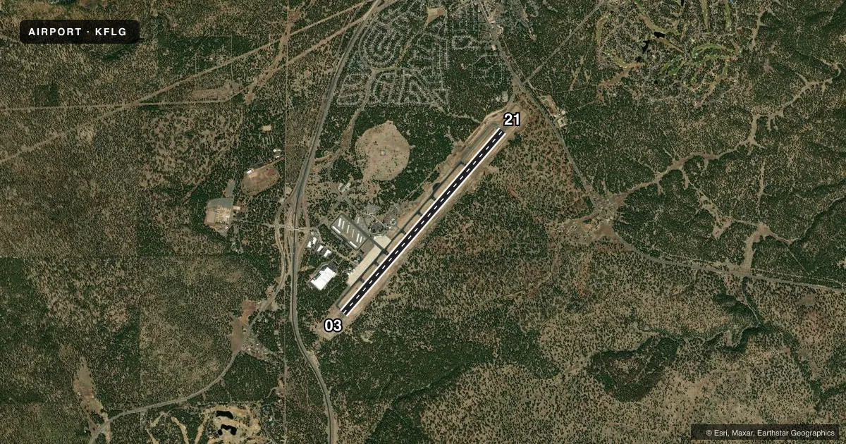
Runways & pattern
Full pagePattern entry · RWY 21
LEFT TRAFFICRunway end performance
| End | TORA | TODA | ASDA | LDA | VGSI | Approach lights | Obstruction |
|---|---|---|---|---|---|---|---|
| 03 | 8,800' | 8,800' | 8,800' | 8,800' | PAPI 4-box left(3°) | — | — |
| 21 | 8,800' | 8,800' | 8,800' | 7,000' | PAPI 4-box left(3°) | MALSR | — |
Declared distances in feet. TORA = takeoff run available, TODA = takeoff distance, ASDA = accelerate-stop, LDA = landing distance.
Airport sketch
Runways drawn to scale from FAA survey coordinates, rendered over satellite imagery. Not for navigation.
Approaches & charts
ILS · 1
Services on the field
Fuel grades, oxygen, maintenance, ramp storage and lighting — as declared to the FAA by the airport operator.
Fuel & services
- Fuel
- 100LLA
- Oxygen (bulk)
- Low pressure
- Airframe repair
- Major
- Power plant repair
- Major
- Other services
- AFRT,AMB,CHTR,INSTR,RNTL,SALES
Ramp & ground
- Transient storage
- Tie-down
- Hangar
- Landing fee
- No fee published
- Customs
- Not available
- Lighting schedule
- SEE RMK
- Beacon schedule
- SS-SR
- Beacon
- White / Green (civil land)(WG)
- Wind indicator
- Lighted
- Segmented circle
- No
Fuel & FBOs
Cheapest 100LL and Jet A on the field and nearby. Always confirm with the FBO before taxi.
Airport notes
Surface conditions, obstructions, local procedures, lighting outages and other notes published with each FAA cycle.
General notes
- SNOW REMOVAL EQUIP MAY BE ON RWY; MNT 134.55 WHEN ATCT CLSD. ARPT MAY BE CLSD DURG SNOW REMOVAL OPS.
- NOISE ABATEMENT PROC IN EFT; AVOID FLT OVR VILLAGE 3 MI S.
- ILS UNMON WHEN ATCT CLSD.
- FOR CD WHEN ATCT CLSD, CTC PHOENIX APCH AT 602-306-2565.
- FUEL AVBL H24.
Lighting notes
- WHEN ATCT CLSD ACTVT MALSR RWY 21; HIRL RWY 03/21 - CTAF. PAPI RWY 3/21 ON CONSLY.
Runway surface & condition
- 03/21PCR VALUE: 390/F/C/W/T
- 03/21RWY 21 CALM WIND RWY. EXP WS & TURB WHEN SFC WINDS EXCEED 10 KT.
Other notes
- TPA: CONVENTIONAL ACFT 989 FT AGL, HELICOPTER 489 FT AGL, HIGH PERFORMANCE 1489 FT AGL.
- MANAGEREXT 10
VFR map & nearby airports
VFR sectional. Tap any ICAO chip to open that airport.
Key facts · KFLG
Answer card- ICAO
- KFLG
- Name
- FLAGSTAFF PULLIAM
- Location
- FLAGSTAFF, ARIZONA
- Elevation
- 7,014.7 ft MSL
- Traffic pattern altitude
- 8,014.7 ft MSL (1,000 AGL)
- Control tower
- Towered · 0600-2100 (1 APR-30 SEP); 0700-1900 (1 OCT-31 MAR)
- Total runways
- 1
- Longest runway
- 03/21 · 8,800 ft
- Published ILS approaches
- 1
- Published frequencies
- 9
- Magnetic variation
- 10°
- Current flight rules
- VFR
- Current wind
- 210° at 4 kt
- Favored runway now
- RWY 21
Flagstaff Pulliam Airport sits in Flagstaff, Arizona. The field elevation is 7,014.7 ft MSL. It has one runway, 03/21, which is 8,800 ft long. The airport is towered. Tower hours are 0600-2100 from 1 APR to 30 SEP. Hours are 0700-1900 from 1 OCT to 31 MAR. There is one ILS approach to runway 21. The published traffic pattern altitude is not given as a standard field-wide value. The Chart Supplement lists 989 ft AGL for conventional aircraft. It lists 489 ft AGL for helicopters. It lists 1,489 ft AGL for high performance aircraft.
Wiseman Aviation is on the field. It carries 100LL, Jet A and Jet A Prist. Fuel is available 24 hours a day. When the tower is closed, the ILS is unmonitored. Clearance delivery then goes through Phoenix Approach. This is high-elevation mountain flying. Expect performance to change with density altitude. Noise abatement is published. Avoid flight over the village 3 miles south. Runway 21 is the calm wind runway. The Chart Supplement also notes wind shear and turbulence when surface winds exceed 10 knots. Snow removal equipment may be on the runway in winter. Monitor 134.55 when the tower is closed.