METAR & TAF KCMR
Current METAR
Observed 12:55Z
KCMR 271255Z AUTO 16008KT 10SM CLR 15/12 A3033 RMK AO2
- Wind
- 160° @ 8 kt
- Visibility
- 10 SM
- Temp / Dew
- 15°C / 12°C
- Altimeter
- 30.33 inHg
- Clouds
- CLR
- Density alt
- 7,788 ft
- Ceiling
- Unlimited
- Rules
- VFR
Airport info & contacts
Manager on record, flight service, ARTCC, attendance schedule and pattern altitude — published by the FAA and refreshed every 28 days.
Location
- From city
- 3 NM N
- VFR sectional
- PHOENIX
- ARTCC
- ZAB · ALBUQUERQUE
- NOTAM facility
- PRC (NOTAM-D)
Airport manager
- Name
- BRAD OLSON
- Phone
- 928-635-8982
- Address
- 3501 NORTH AIRPORT ROAD, WILLIAMS AZ 86046
Flight service · Hours
- FSS PRC
- PRESCOTT1-800-WX-BRIEF
- Attendance
- 0900-1500
Frequencies
Tap any row to copy the frequency to your clipboard.
Runways & pattern
Full pagePattern entry · RWY 18
LEFT TRAFFICRunway end performance
| End | TORA | TODA | ASDA | LDA | VGSI | Approach lights | Obstruction |
|---|---|---|---|---|---|---|---|
| 18 | — | — | — | — | PAPI 2-box left(3°) | — | 12', tree, 215' from thr, 200' R of cntrln, slope 1 |
| 36 | — | — | — | — | PAPI 2-box left(3°) | — | — |
Declared distances in feet. TORA = takeoff run available, TODA = takeoff distance, ASDA = accelerate-stop, LDA = landing distance.
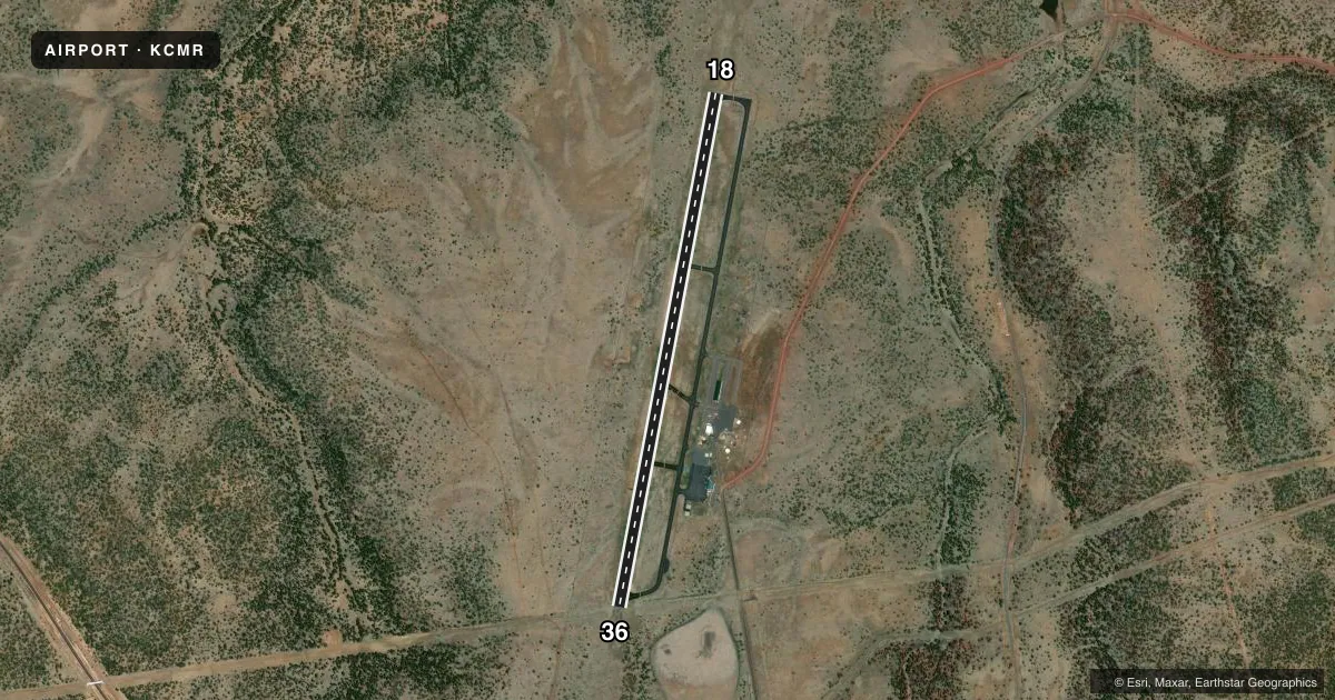
Airport sketch
Runways drawn to scale from FAA survey coordinates, rendered over satellite imagery. Not for navigation.
Approaches & charts
Services on the field
Fuel grades, oxygen, maintenance, ramp storage and lighting — as declared to the FAA by the airport operator.
Fuel & services
- Fuel
- 100LLA1+
- Airframe repair
- Major
- Power plant repair
- Major
Ramp & ground
- Transient storage
- Tie-down
- Hangar
- Landing fee
- No fee published
- Customs
- Not available
- Lighting schedule
- SEE RMK
- Beacon schedule
- SS-SR
- Beacon
- White / Green (civil land)(WG)
- Wind indicator
- Lighted
- Segmented circle
- Yes
Fuel & FBOs
Cheapest 100LL and Jet A on the field and nearby. Always confirm with the FBO before taxi.
Airport notes
Surface conditions, obstructions, local procedures, lighting outages and other notes published with each FAA cycle.
General notes
- FOR CD CTC ALBUQUERQUE ARTCC AT 505-856-4861.
- WINTER FICON - AMGR.
Lighting notes
- ACTVT REIL RWY 18 & 36; PAPI RWY 18 & 36; MIRL RWY 18/36 - CTAF.
Fuel notes
- 100LLSELF SVC WITH CREDIT CARD H24.
- A1+FULL SVC AVBL BY APPT - AMGR OR 928-300-8385.
Runway surface & condition
- 18/3610-15 FT TREES & BRUSH 120 FT - 170 FT W OF CNTRLN FULL LEN.
Approach & departure obstructions
- 18+3 FT BERM 65-200 FT FM RWY END 150 FT L & R; 13 FT TREE 155 FT FM RWY END 180 FT R.
- 36+5 FT ROCK 20-75 FT FM THLD 175-250 FT L CNTRLN; 4 FT WEEDS 20-200 FT FM RWY END XS THR.
- 18393 FT HILL 7800 FT FM RWY END ON CNTRLN.
- 36479 FT HILL 8800 FT FM RWY END ON CNTRLN.
Other notes
- CALL PRIOR.
- MANAGEREMERG - 928-635-4461 WILLIAMS POLICE DEPT.
- MANAGER928-300-8353
VFR map & nearby airports
VFR sectional. Tap any ICAO chip to open that airport.
Key facts · KCMR
Answer card- ICAO
- KCMR
- Name
- H A CLARK MEML FLD
- Location
- WILLIAMS, ARIZONA
- Elevation
- 6,690.8 ft MSL
- Traffic pattern altitude
- 7,690.8 ft MSL (1,000 AGL)
- Control tower
- Non-towered (use CTAF)
- Total runways
- 1
- Longest runway
- 18/36 · 6,003 ft
- Published ILS approaches
- 0
- Published frequencies
- 2
- Magnetic variation
- 13°
- Current flight rules
- VFR
- Current wind
- 160° at 8 kt
- Favored runway now
- RWY 18
H A Clark Meml Fld sits in Williams, Arizona at 6,690.8 ft MSL. It has one runway, 18/36, which is 6,003 ft long. The field is non-towered. CTAF and UNICOM are both 122.8. No ILS approaches are published here.
For pattern work, the published pattern altitude is not listed. Use the standard 1,000 ft AGL for light piston operations unless the current Chart Supplement says otherwise. That puts you in high-elevation country, so performance planning matters. Expect thinner air. Expect longer takeoff rolls. Expect less climb margin than you would see at a low field. There is also a 393 ft hill 7,800 ft from the runway end on the runway 18 centerline. Trees and brush also sit west of the runway 18/36 centerline along much of the strip. Runway 18/36 has medium intensity lighting controlled by CTAF. REILs and PAPI are installed on both ends.
NAZ Aviation is on the field. It carries 100LL and Jet A Prist. Self-serve 100LL is available 24 hours a day with credit card. Full service fuel is available by appointment through the airport manager. Clearance delivery is handled through Albuquerque ARTCC. Call ahead before arrival. Winter field conditions are managed by the airport manager.