METAR & TAF L37
L37 does not publish a METAR.
Showing the nearest reporting station: KIGM (KINGMAN) · 37.4 NM away. Conditions at L37 may differ.
METAR · KIGM
Observed 17:51Z
KIGM 251751Z AUTO 10SM CLR 38/12 A3007 RMK AO2 SLP096 T03780117 10378 20272 51001 $
- Wind
- Calm
- Visibility
- 10 SM
- Temp / Dew
- 38°C / 12°C
- Altimeter
- 30.07 inHg
- Clouds
- CLR
- Density alt
- 9,266 ft
- Ceiling
- Unlimited
- Rules
- VFR
Airport info & contacts
Manager on record, flight service, ARTCC, attendance schedule and pattern altitude — published by the FAA and refreshed every 28 days.
Location
- From city
- 9 NM E
- VFR sectional
- PHOENIX
- ARTCC
- ZLA · LOS ANGELES
- NOTAM facility
- PRC (NOTAM-D)
Airport manager
- Name
- MATTHEW LUSHER
- Phone
- 928-422-3223
- Address
- P.O. BOX 180, PEACH SPRINGS AZ 86434
Flight service · Hours
- FSS PRC
- PRESCOTT1-800-WX-BRIEF
- Attendance
- DALGT
Frequencies
Tap any row to copy the frequency to your clipboard.
Runways & pattern
Full pagePattern entry · RWY 05
LEFT TRAFFICRunway end performance
| End | TORA | TODA | ASDA | LDA | VGSI | Approach lights | Obstruction |
|---|---|---|---|---|---|---|---|
| 05 | — | — | — | — | — | — | 4', fence, 0' from thr, 80' R of cntrln, slope 0 |
| 23 | — | — | — | — | — | — | 6', fence, 45' from thr, 0' R of cntrln, slope 7 |
Declared distances in feet. TORA = takeoff run available, TODA = takeoff distance, ASDA = accelerate-stop, LDA = landing distance.
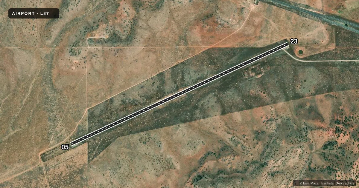
Airport sketch
Runways drawn to scale from FAA survey coordinates, rendered over satellite imagery. Not for navigation.
Approaches & charts
Services on the field
Fuel grades, oxygen, maintenance, ramp storage and lighting — as declared to the FAA by the airport operator.
Fuel & services
- Fuel
- Not available
Ramp & ground
- Transient storage
- Hangar
- Landing fee
- No fee published
- Wind indicator
- Yes
- Segmented circle
- No
Fuel & FBOs
Cheapest 100LL and Jet A on the field and nearby. Always confirm with the FBO before taxi.
Airport notes
Surface conditions, obstructions, local procedures, lighting outages and other notes published with each FAA cycle.
General notes
- WILDLIFE INVOF ARPT.
- FOR CD CTC LOS ANGELES ARTCC AT 661-575-2079.
- MNT 122.8 WI 5 NM.
Runway surface & condition
- 05/233 FT BRUSH 10 FT FM RWY FULL LEN.
Approach & departure obstructions
- 05300 FT
- 23300 FT.
- 054-6 FT FENCE -200 FT FM DTHR BOTH SIDES.
- 23FENCE IN PRIM SFC 400-800 FT FM THR.
- 05DTHR MKD WITH 2 TIRES BOTH SIDES.
- 23DTHR MKD WITH 2 TIRES BOTH SIDES.
- 05CLNC SLOPE 0:1 AT DTHR; 4 FT FENCE 80 FT FM CNTRLN BOTH SIDES.
- 23CLNC SLOPE 20:1 AT DTHR.
Other notes
- AVBL - AMGR.
- MANAGEREX 109
VFR map & nearby airports
VFR sectional. Tap any ICAO chip to open that airport.
Key facts · L37
Answer card- ICAO
- L37
- Name
- GRAND CANYON CAVERNS
- Location
- PEACH SPRINGS, ARIZONA
- Elevation
- 5,397 ft MSL
- Traffic pattern altitude
- 6,397 ft MSL (1,000 AGL)
- Control tower
- Non-towered (use CTAF)
- Total runways
- 1
- Longest runway
- 05/23 · 5,100 ft
- Published ILS approaches
- 0
- Published frequencies
- 2
- Magnetic variation
- 13°
- Current flight rules
- VFR
- Current wind
- Calm / unavailable
- Favored runway now
- –
Grand Canyon Caverns is in Peach Springs, Arizona. Field elevation is 5,397 ft MSL. The airport has one runway. Runway 05/23 is 5,100 ft long and gravel. There is no control tower. CTAF and UNICOM are both 122.8. Monitor 122.8 within 5 NM of the field.
No ILS approaches are published here. Pattern altitude is not published in the facts, so use the current FAA Chart Supplement before you go. For a light piston, plan on the standard 1,000 ft AGL pattern unless the current published data says otherwise. The field sits in high terrain. Density altitude will matter on warm days. Expect performance to be a real factor at this elevation.
Published remarks call out displaced thresholds on both ends. Runway 05 has a 300 ft displaced threshold. Runway 23 also has a 300 ft displaced threshold. There is a fence near runway 23 in the primary surface. Wildlife is also noted in the area. No on-field FBOs are listed. Fuel and services are available by airport manager, so call ahead for current support before arrival. For clearance delivery, contact Los Angeles ARTCC at 661-575-2079.