METAR & TAF L25
L25 does not publish a METAR.
Showing the nearest reporting station: KBVU (BOULDER CITY MUNI) · 40.5 NM away. Conditions at L25 may differ.
METAR · KBVU
Observed 23:55Z
KBVU 262355Z AUTO 25013G21KT 10SM CLR 42/08 A2985 RMK AO2
- Wind
- 250° @ 13G21 kt
- Visibility
- 10 SM
- Temp / Dew
- 42°C / 8°C
- Altimeter
- 29.85 inHg
- Clouds
- CLR
- Density alt
- 6,974 ft
- Ceiling
- Unlimited
- Rules
- VFR
Airport info & contacts
Manager on record, flight service, ARTCC, attendance schedule and pattern altitude — published by the FAA and refreshed every 28 days.
Location
- From city
- 3 NM N
- VFR sectional
- LAS VEGAS
- ARTCC
- ZLA · LOS ANGELES
- NOTAM facility
- PRC (NOTAM-D)
Airport manager
- Name
- IAN MORRIS
- Phone
- 702-659-3771
- Address
- 601 NEVADA HIGHWAY, BOULDER CITY NV 89005
Flight service · Hours
- FSS PRC
- PRESCOTT1-800-WX-BRIEF
- Attendance
- Unattended
Frequencies
Tap any row to copy the frequency to your clipboard.
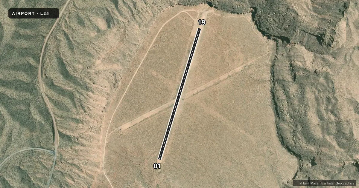
Runways & pattern
Full pagePattern entry · RWY 19
LEFT TRAFFICAirport sketch
Runways drawn to scale from FAA survey coordinates, rendered over satellite imagery. Not for navigation.
Approaches & charts
Services on the field
Fuel grades, oxygen, maintenance, ramp storage and lighting — as declared to the FAA by the airport operator.
Fuel & services
- Fuel
- Not available
Ramp & ground
- Transient storage
- Not published
- Landing fee
- No fee published
- Wind indicator
- Yes
Fuel & FBOs
Cheapest 100LL and Jet A on the field and nearby. Always confirm with the FBO before taxi.
Airport notes
Surface conditions, obstructions, local procedures, lighting outages and other notes published with each FAA cycle.
General notes
- WILDLIFE ON & INVOF ARPT.
- CTN: CLSD RWY MKD BY TIRES.
- FOR CD CTC LOS ANGELES ARTCC AT 661-575-2079.
Runway surface & condition
- 01/19+5 FT BUSHES ALG E & W SIDE.
- 01/19CNTR 50 FT CLEAR OF VEGETATION.
Approach & departure obstructions
- 01SIGNS 1050 FT FM RWY END 90 FT L. 550 FT STWY SOUTH OF RWY CVRD WITH LRG ROCKS & VEGETATION.
- 19SIGNS 200 FT FM RWY END 110 FT L. GRAVEL APRON W SIDE OF AER.
Other notes
- VFR, PUBLIC USE.
- MANAGEREMERG - 702-293-8998
VFR map & nearby airports
VFR sectional. Tap any ICAO chip to open that airport.
Key facts · L25
Answer card- ICAO
- L25
- Name
- PEARCE FERRY
- Location
- MEADVIEW, ARIZONA
- Elevation
- 2,941 ft MSL
- Traffic pattern altitude
- 3,941 ft MSL (1,000 AGL)
- Control tower
- Non-towered (use CTAF)
- Total runways
- 1
- Longest runway
- 01/19 · 2,900 ft
- Published ILS approaches
- 0
- Published frequencies
- 1
- Magnetic variation
- 14°
- Current flight rules
- VFR
- Current wind
- 250° at 13 kt
- Favored runway now
- RWY 19
Pearce Ferry Airport sits near Meadview, Arizona. The field elevation is 2,941 ft MSL. It has one runway. Runway 01/19 is 2,900 ft long and is a dirt strip. The airport is not towered. CTAF is 122.9.
No ILS approaches are published here. Pattern altitude is not published, so use standard traffic pattern judgment and verify the current Chart Supplement before you go. This is a VFR public-use field. The published remarks also call out wildlife on and near the airport. There are signs near the runway ends. The south stopway is reported covered with large rocks and vegetation. Five-foot bushes are noted along both sides of the runway. The center 50 feet is listed as clear of vegetation.
There are no on-field FBOs listed. Plan on self-sufficiency and call the airport operator directly if you need current services. The published remarks give an emergency number of 702-293-8998. For clearance delivery, contact Los Angeles ARTCC at 661-575-2079. With the field sitting at nearly 3,000 ft MSL in a remote desert area, expect density altitude to matter. Check the current Chart Supplement for any operational notes before arrival.