METAR & TAF 0L9
0L9 does not publish a METAR.
Showing the nearest reporting station: KBVU (BOULDER CITY MUNI) · 29.1 NM away. Conditions at 0L9 may differ.
METAR · KBVU
Observed 10:35Z
KBVU 271035Z AUTO 00000KT 10SM CLR 34/10 A2986 RMK AO2
- Wind
- 000° @ 0 kt
- Visibility
- 10 SM
- Temp / Dew
- 34°C / 10°C
- Altimeter
- 29.86 inHg
- Clouds
- CLR
- Density alt
- 4,258 ft
- Ceiling
- Unlimited
- Rules
- VFR
Airport info & contacts
Manager on record, flight service, ARTCC, attendance schedule and pattern altitude — published by the FAA and refreshed every 28 days.
Location
- From city
- 14 NM S
- VFR sectional
- LAS VEGAS
- ARTCC
- ZLA · LOS ANGELES
- NOTAM facility
- RNO (NOTAM-D)
Airport manager
- Name
- LAKE MEAD NATL REC AREA
- Phone
- 702-293-8990
- Address
- NATIONAL PARK SERVICE, INTER REG 8, 601 NEVADA HIGHWAY, BOULDER NV 89005
Flight service · Hours
- FSS RNO
- RENO1-800-WX-BRIEF
- Attendance
- ON CALL
Frequencies
Tap any row to copy the frequency to your clipboard.
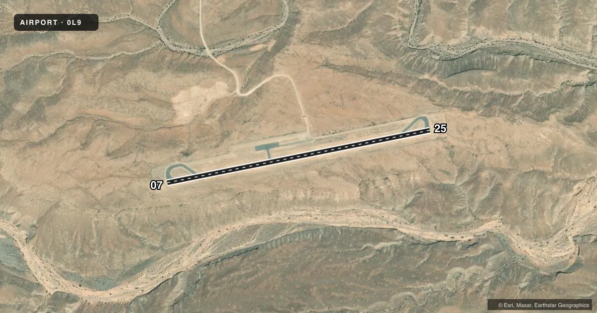
Runways & pattern
Full pagePattern entry · RWY 07
LEFT TRAFFICAirport sketch
Runways drawn to scale from FAA survey coordinates, rendered over satellite imagery. Not for navigation.
Approaches & charts
Services on the field
Fuel grades, oxygen, maintenance, ramp storage and lighting — as declared to the FAA by the airport operator.
Fuel & services
- Fuel
- Not available
- Other services
- AMB,INSTR
Ramp & ground
- Transient storage
- Tie-down
- Landing fee
- No fee published
- Customs
- Not available
- Segmented circle
- Yes
Fuel & FBOs
Cheapest 100LL and Jet A on the field and nearby. Always confirm with the FBO before taxi.
Airport notes
Surface conditions, obstructions, local procedures, lighting outages and other notes published with each FAA cycle.
General notes
- LIVESTOCK ON & INVOF ARPT.
- PARL TWY ROUGH AND FOD DUE TO INFQT USE.
- FOR CD CTC LOS ANGELES ARTCC AT 661-575-2079.
- RESORT TAXI SVC - MON UNICOM.
Runway surface & condition
- 07/25ARR RWY 25 & DEP RWY 7 RCMDD IN LGT WIND DUE TO SLP.
Other notes
- MANAGEREMERG - 702-293-8932.
VFR map & nearby airports
VFR sectional. Tap any ICAO chip to open that airport.
Key facts · 0L9
Answer card- ICAO
- 0L9
- Name
- ECHO BAY
- Location
- OVERTON, NEVADA
- Elevation
- 1,535 ft MSL
- Traffic pattern altitude
- 2,535 ft MSL (1,000 AGL)
- Control tower
- Non-towered (use CTAF)
- Total runways
- 1
- Longest runway
- 07/25 · 3,400 ft
- Published ILS approaches
- 0
- Published frequencies
- 2
- Magnetic variation
- 14°
- Current flight rules
- VFR
- Current wind
- 000° at 0 kt
- Favored runway now
- –
Echo Bay Airport sits near Overton, Nevada. Field elevation is 1,535 ft MSL. The airport has one runway. Runway 07/25 is 3,400 ft of asphalt. There is no control tower. CTAF and UNICOM are both 122.8. No ILS approaches are published here.
Pattern altitude is not published. Use 1,000 ft AGL as the standard light piston pattern unless the current FAA Chart Supplement says otherwise. The published remarks matter here. The parallel taxiway is rough and has foreign object debris because the field sees infrequent use. Livestock are on and near the airport. In light wind, arrivals to runway 25 and departures from runway 7 are recommended because of runway slope. If you need clearance delivery, contact Los Angeles ARTCC at 661-575-2079.
There are no on-field FBOs listed. Plan fuel and service with the airport operator or the FBO directly by phone before you go. For a first visit, treat this as a non-towered desert airport with extra attention on taxi and runway condition. Check the current FAA Chart Supplement for any updated operational notes before departure.