METAR & TAF 67L
67L does not publish a METAR.
Showing the nearest reporting station: KSGU (ST GEORGE RGNL) · 28.9 NM away. Conditions at 67L may differ.
METAR · KSGU
Observed 11:56Z
KSGU 271156Z AUTO 12006KT 10SM CLR 27/12 A2997 RMK AO2 SLP108 T02720122 10311 20267 53006
- Wind
- 120° @ 6 kt
- Visibility
- 10 SM
- Temp / Dew
- 27°C / 12°C
- Altimeter
- 29.97 inHg
- Clouds
- CLR
- Density alt
- 3,831 ft
- Ceiling
- Unlimited
- Rules
- VFR
Airport info & contacts
Manager on record, flight service, ARTCC, attendance schedule and pattern altitude — published by the FAA and refreshed every 28 days.
Location
- From city
- 2 NM N
- VFR sectional
- LAS VEGAS
- ARTCC
- ZLA · LOS ANGELES
- NOTAM facility
- RNO (NOTAM-D)
Airport manager
- Name
- TRAVIS ANDERSON
- Phone
- 702-346-5237
- Address
- 10 E MESQUITE BLVD, MESQUITE NV 89027
Flight service · Hours
- FSS RNO
- RENO1-800-WX-BRIEF
- Attendance
- 0700-1700
Frequencies
Tap any row to copy the frequency to your clipboard.
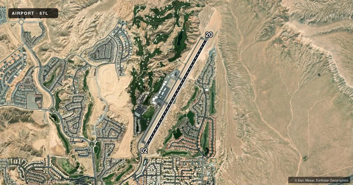
Runways & pattern
Full pagePattern entry · RWY 20
LEFT TRAFFICRunway end performance
| End | TORA | TODA | ASDA | LDA | VGSI | Approach lights | Obstruction |
|---|---|---|---|---|---|---|---|
| 02 | — | — | — | — | PAPI 2-box left(3°) | — | — |
| 20 | — | — | — | — | PAPI 2-box left(3°) | — | 140', hill, 2800' from thr, 0' R of cntrln, slope 18 |
Declared distances in feet. TORA = takeoff run available, TODA = takeoff distance, ASDA = accelerate-stop, LDA = landing distance.
Airport sketch
Runways drawn to scale from FAA survey coordinates, rendered over satellite imagery. Not for navigation.
Approaches & charts
Services on the field
Fuel grades, oxygen, maintenance, ramp storage and lighting — as declared to the FAA by the airport operator.
Fuel & services
- Fuel
- 100LLA
- Oxygen (bottled)
- Not available
- Oxygen (bulk)
- Not available
- Airframe repair
- Not available
- Power plant repair
- Not available
- Other services
- AMB,CARGO,GLD,PAJA
Ramp & ground
- Transient storage
- Tie-down
- Lighting schedule
- SEE RMK
- Beacon schedule
- SS-SR
- Beacon
- White / Green (civil land)(WG)
- Wind indicator
- Yes
- Segmented circle
- Yes
Fuel & FBOs
Cheapest 100LL and Jet A on the field and nearby. Always confirm with the FBO before taxi.
Airport notes
Surface conditions, obstructions, local procedures, lighting outages and other notes published with each FAA cycle.
General notes
- NOISE ABATEMENT PROC; AVOID OVR FLT DOWNTOWN MESQUITE 2 NM SW.
- PUB ACT WI 1000 FT OF RWY.
- FOR CD CTC LOS ANGELES ARTCC AT 661-575-2079.
- OTR CTC FBO - 702-246-2841/262-707-5980.
Lighting notes
- ACTVT MIRL RWY 02/20 - CTAF.
Fuel notes
- 100LL100LL AVBL SELF SVC WITH CREDIT CARD.
Runway surface & condition
- 02/20PCR VALUE: 170/F/C/X/T
- 02/20-20 FT DROPOFF 90 FT R & PARL TO CNTRLN. ARR RWY 02 & DEP RWY 20 RCMDD IN NO WIND COND DUE TO SLOPE.
Approach & departure obstructions
- 02+3 FT FENCE 88 FT L & PARL TO CNTRLN.
VFR map & nearby airports
VFR sectional. Tap any ICAO chip to open that airport.
Key facts · 67L
Answer card- ICAO
- 67L
- Name
- MESQUITE
- Location
- MESQUITE, NEVADA
- Elevation
- 1,978.1 ft MSL
- Traffic pattern altitude
- 2,978.1 ft MSL (1,000 AGL)
- Control tower
- Non-towered (use CTAF)
- Total runways
- 1
- Longest runway
- 02/20 · 5,121 ft
- Published ILS approaches
- 0
- Published frequencies
- 2
- Magnetic variation
- 11°
- Current flight rules
- VFR
- Current wind
- 120° at 6 kt
- Favored runway now
- RWY 20
Mesquite Airport sits in Mesquite, Nevada. The field elevation is 1,978.1 ft MSL. It has one runway. Runway 02/20 is 5,121 ft long and asphalt. There is no control tower. CTAF and UNICOM are both 122.8. No ILS approaches are published here.
The published pattern altitude is not listed. Use the standard 1,000 ft AGL for light piston traffic unless the current Chart Supplement says otherwise. The airport has one on-field FBO, Mesquite Airport. It carries 100LL, Jet A and Jet A Prist. Self-serve 100LL is available with credit card. The runway lights are medium intensity. They are activated on CTAF.
There are a few things a first-time pilot should plan for. Noise abatement calls for avoiding overflight of downtown Mesquite within 2 NM southwest. Public activity occurs within 1,000 ft of the runway. Runway 02 has a 3 ft fence 88 ft left of centerline near the threshold. There is also a 20 ft dropoff 90 ft right and parallel to the centerline. In no-wind conditions, arrival on runway 02 and departure on runway 20 are recommended because of the slope. Check the current Chart Supplement before you go if you need more detail on local procedures.