METAR & TAF U30
U30 does not publish a METAR.
Showing the nearest reporting station: KBVU (BOULDER CITY MUNI) · 25.9 NM away. Conditions at U30 may differ.
METAR · KBVU
Observed 11:35Z
KBVU 271135Z AUTO 00000KT 10SM CLR 34/10 A2987 RMK AO2
- Wind
- 000° @ 0 kt
- Visibility
- 10 SM
- Temp / Dew
- 34°C / 10°C
- Altimeter
- 29.87 inHg
- Clouds
- CLR
- Density alt
- 4,263 ft
- Ceiling
- Unlimited
- Rules
- VFR
Airport info & contacts
Manager on record, flight service, ARTCC, attendance schedule and pattern altitude — published by the FAA and refreshed every 28 days.
Location
- From city
- 1 NM SW
- VFR sectional
- LAS VEGAS
- ARTCC
- ZLA · LOS ANGELES
- NOTAM facility
- PRC (NOTAM-D)
Airport manager
- Name
- IAN MORRIS
- Phone
- 702-659-3771
- Address
- 601 NEVADA HWY, BOULDER CITY NV 89005
Flight service · Hours
- FSS PRC
- PRESCOTT1-800-WX-BRIEF
- Attendance
- Unattended
Frequencies
Tap any row to copy the frequency to your clipboard.
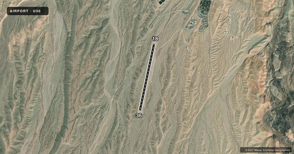
Runways & pattern
Full pagePattern entry · RWY 18
RIGHT TRAFFICRunway end performance
| End | TORA | TODA | ASDA | LDA | VGSI | Approach lights | Obstruction |
|---|---|---|---|---|---|---|---|
| 36 | — | — | — | — | — | — | 7', brush, 290' from thr, 10' R of cntrln, slope 12 |
Declared distances in feet. TORA = takeoff run available, TODA = takeoff distance, ASDA = accelerate-stop, LDA = landing distance.
Airport sketch
Runways drawn to scale from FAA survey coordinates, rendered over satellite imagery. Not for navigation.
Approaches & charts
Services on the field
Fuel grades, oxygen, maintenance, ramp storage and lighting — as declared to the FAA by the airport operator.
Fuel & services
- Fuel
- Not available
Ramp & ground
- Transient storage
- Tie-down
- Landing fee
- No fee published
- Customs
- Not available
- Wind indicator
- Yes
- Segmented circle
- Yes
Fuel & FBOs
Cheapest 100LL and Jet A on the field and nearby. Always confirm with the FBO before taxi.
Airport notes
Surface conditions, obstructions, local procedures, lighting outages and other notes published with each FAA cycle.
General notes
- LND UPHILL TO S; +2% UP SLOPE FM RWY 18 TO 36.
- DO NOT USE TIE DOWN AREA AS PARL TWY; BACK TAXI ON RWY.
- WILDLIFE ON & INVOF ARPT.
- N TURN AROUND LOOSE ROCK.
- RAMP COND POOR; RUTS & EROSION; USE S HALF. 12 IN RUTS N HALF IN TIE DOWN AREA.
- FOR CD CTC LOS ANGELES ARTCC AT 661-575-2079.
- ALL PAVED SFCS 2 FT BRUSH FM CRACKS.
Runway surface & condition
- 18/36VEHICLE TFC ON RWY. 20 FT BERM 180 FT W FULL LEN.
Approach & departure obstructions
- 182-4 FT SCATTERED BRUSH 0-200 FT FM THR 60-125 FT R OF CNTRLN.
- 36TRRN RISES CONSTANT RATE ABOVE RWY.
- 18FADED.
- 36FADED.
Other notes
- TRNSPN - CTAF.
- OWNERLAKE MEAD NATIONAL RECREATION AREA.
- OWNER702-293-8998.
- 18/36NMRS CRACKS & LOOSE ROCK.
VFR map & nearby airports
VFR sectional. Tap any ICAO chip to open that airport.
Key facts · U30
Answer card- ICAO
- U30
- Name
- TEMPLE BAR
- Location
- TEMPLE BAR, ARIZONA
- Elevation
- 1,549 ft MSL
- Traffic pattern altitude
- 2,549 ft MSL (1,000 AGL)
- Control tower
- Non-towered (use CTAF)
- Total runways
- 1
- Longest runway
- 18/36 · 3,500 ft
- Published ILS approaches
- 0
- Published frequencies
- 2
- Magnetic variation
- 14°
- Current flight rules
- VFR
- Current wind
- 000° at 0 kt
- Favored runway now
- –
Temple Bar Airport sits in Temple Bar, Arizona near Lake Mead National Recreation Area. Field elevation is 1,549 ft MSL. The airport has one runway. Runway 18/36 is 3,500 ft asphalt. There is no control tower. CTAF and UNICOM are both 122.8. No ILS approaches are published.
The pattern altitude is not published. Use the standard 1,000 ft AGL pattern unless the current Chart Supplement says otherwise. For this field that puts the light piston pattern at about 2,549 ft MSL. The published remarks matter here. Expect loose rock, cracks in the pavement, wildlife in the area. Brush can also be found along the paved surfaces. There is also vehicle traffic on the runway at times. Do not use the tie-down area as a taxiway. Back taxi on the runway instead.
Runway 18 has scattered brush near the threshold on the right side. Runway 36 markings are faded. The runway has a 2 percent upslope from 18 to 36. Land uphill to the south. Terrain also rises above runway 36. For clearance delivery, contact Los Angeles ARTCC at 661-575-2079. No on-field FBOs are listed, so verify fuel and services with the airport operator or call ahead before you go.