METAR & TAF 40G
40G does not publish a METAR.
Showing the nearest reporting station: KGCN (GRAND CANYON NTL PARK) · 18.1 NM away. Conditions at 40G may differ.
METAR · KGCN
Observed 04:54Z
KGCN 270454Z 00000KT 10SM CLR 21/12 A3033 RMK AO2 SLP153 T02060117
- Wind
- 000° @ 0 kt
- Visibility
- 10 SM
- Temp / Dew
- 21°C / 12°C
- Altimeter
- 30.33 inHg
- Clouds
- CLR
- Density alt
- 7,650 ft
- Ceiling
- Unlimited
- Rules
- VFR
Airport info & contacts
Manager on record, flight service, ARTCC, attendance schedule and pattern altitude — published by the FAA and refreshed every 28 days.
Location
- From city
- 25 NM S
- VFR sectional
- PHOENIX
- ARTCC
- ZLA · LOS ANGELES
- NOTAM facility
- PRC (NOTAM-D)
Airport manager
- Name
- NORM GOBEIL
- Phone
- 928-380-0698
- Address
- 908 WEST MURRAY ROAD, WILLIAMS AZ 86001-5013
Flight service · Hours
- FSS PRC
- PRESCOTT1-800-WX-BRIEF
Frequencies
Tap any row to copy the frequency to your clipboard.
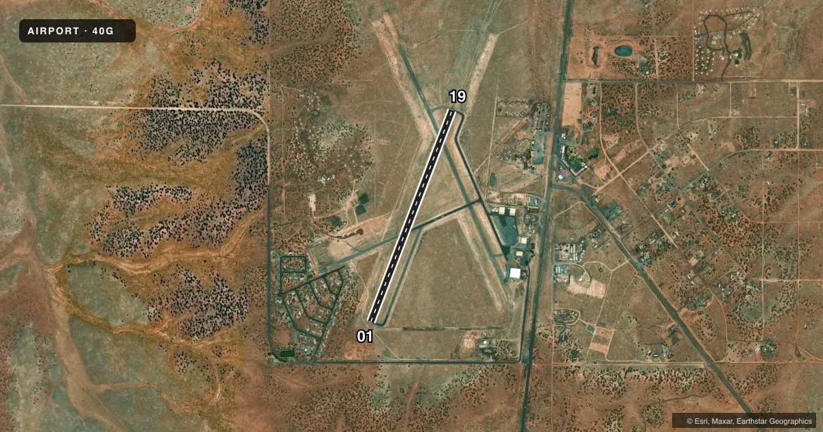
Runways & pattern
Full pagePattern entry · RWY 01
LEFT TRAFFICAirport sketch
Runways drawn to scale from FAA survey coordinates, rendered over satellite imagery. Not for navigation.
Approaches & charts
Services on the field
Fuel grades, oxygen, maintenance, ramp storage and lighting — as declared to the FAA by the airport operator.
Fuel & services
- Fuel
- Not available
Ramp & ground
- Transient storage
- Not published
- Landing fee
- No fee published
- Wind indicator
- Yes
- Segmented circle
- Yes
Fuel & FBOs
Cheapest 100LL and Jet A on the field and nearby. Always confirm with the FBO before taxi.
Airport notes
Surface conditions, obstructions, local procedures, lighting outages and other notes published with each FAA cycle.
General notes
- WILDLIFE ON & INVOF ARPT.
- FOR CD CTC LA ARTCC AT 661-575-2079.
- WINTER MAINT NA; FOR CONDS - AMGR.
- HEL TRNG INVOF ARPT - MNT 122.8 WI 5 NM.
Approach & departure obstructions
- 0110 FT ROAD 200 FT FM THR ACRS APCH AREA 250 FT EACH SIDE; 2 FT BRUSH 200 FT FM THR 90-250 FT L OF CNTRLN.
- 19FLT DMSTN 850-1000 FT E OF THR.
- 01CNTRLN POOR; CRACK FILLER CVRG PAINT.
- 19CNTRLN POOR; CRACK FILLER CVRG PAINT.
Other notes
- VFR ONLY.
- MANAGEREMERG - 928-814-5860.
VFR map & nearby airports
VFR sectional. Tap any ICAO chip to open that airport.
Key facts · 40G
Answer card- ICAO
- 40G
- Name
- VALLE
- Location
- GRAND CANYON, ARIZONA
- Elevation
- 5,999 ft MSL
- Traffic pattern altitude
- 6,999 ft MSL (1,000 AGL)
- Control tower
- Non-towered (use CTAF)
- Total runways
- 1
- Longest runway
- 01/19 · 4,199 ft
- Published ILS approaches
- 0
- Published frequencies
- 2
- Magnetic variation
- 13°
- Current flight rules
- VFR
- Current wind
- 000° at 0 kt
- Favored runway now
- –
Valle Airport (40G) sits in Grand Canyon, Arizona. Field elevation is 5,999 ft MSL. The airport has one runway, 01/19, which is 4,199 ft long and asphalt. There is no control tower. CTAF and UNICOM are both 122.8.
No ILS approaches are published here. The pattern altitude is not published, so use the standard 1,000 ft AGL for light piston traffic unless the current FAA Chart Supplement says otherwise. This is a VFR-only field. That matters here because the airport sits at high elevation. Expect performance planning to matter on warm days. Check density altitude before you go.
There are no on-field FBOs listed. Contact the airport operator directly before arrival if you need local services. Published remarks also call out helicopter training in the area on 122.8 within 5 NM. Wildlife is present on and near the airport. Runway 01 and runway 19 both have centerline paint in poor condition with crack filler covering the markings. There is also an obstruction near each end. For current field conditions, winter maintenance, or clearance delivery, use the airport manager or Los Angeles ARTCC as published.