METAR & TAF KIGM
Current METAR
Observed 10:51Z
KIGM 271051Z AUTO 19006KT 10SM CLR 27/14 A3003 RMK AO2 SLP086 T02720139 $
- Wind
- 190° @ 6 kt
- Visibility
- 10 SM
- Temp / Dew
- 27°C / 14°C
- Altimeter
- 30.03 inHg
- Clouds
- CLR
- Density alt
- 5,580 ft
- Ceiling
- Unlimited
- Rules
- VFR
Airport info & contacts
Manager on record, flight service, ARTCC, attendance schedule and pattern altitude — published by the FAA and refreshed every 28 days.
Location
- From city
- 8 NM NE
- VFR sectional
- PHOENIX
- Pattern altitude
- 800 ft AGL · 4,249 ft MSL
- ARTCC
- ZLA · LOS ANGELES
- NOTAM facility
- IGM (NOTAM-D)
Airport manager
- Name
- DOUG BRECKENRIDGE
- Phone
- 928-757-2134
- Address
- 7000 FLIGHTLINE DR., KINGMAN AZ 86401
Flight service · Hours
- FSS PRC
- PRESCOTT1-800-WX-BRIEF
- Attendance
- MON-FRI · 0600-1600
- SAT-SUN · 0600-1400
Frequencies
Tap any row to copy the frequency to your clipboard.
Runways & pattern
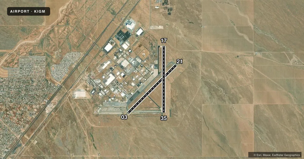
Full pagePattern entry · RWY 17
LEFT TRAFFIC| Runway | Heading (°M) | Length | Surface | Traffic |
|---|---|---|---|---|
| 03/21 | 33° / 213° | 6,827 ft | ASPH | Standard L |
| 17/35Favored | 168° / 348° | 6,725 ft | ASPH | Standard L |
Runway end performance
| End | TORA | TODA | ASDA | LDA | VGSI | Approach lights | Obstruction |
|---|---|---|---|---|---|---|---|
| 03 | 6,827' | 6,827' | 6,827' | 6,827' | PAPI 4-box left(3°) | — | — |
| 21 | 6,827' | 6,827' | 6,827' | 6,827' | PAPI 4-box left(3°) | — | — |
| 17 | 6,725' | 6,725' | 6,725' | 6,725' | PAPI 2-box left(3°) | — | — |
| 35 | 6,725' | 6,725' | 6,725' | 6,725' | PAPI 2-box left(3°) | — | — |
Declared distances in feet. TORA = takeoff run available, TODA = takeoff distance, ASDA = accelerate-stop, LDA = landing distance.
Airport sketch
Runways drawn to scale from FAA survey coordinates, rendered over satellite imagery. Not for navigation.
Approaches & charts
Services on the field
Fuel grades, oxygen, maintenance, ramp storage and lighting — as declared to the FAA by the airport operator.
Fuel & services
- Fuel
- 100LLA
- Oxygen (bulk)
- HIGH/LOW
- Airframe repair
- Major
- Power plant repair
- Major
- Other services
- AFRT,AMB,RNTL
Ramp & ground
- Transient storage
- Tie-down
- Landing fee
- No fee published
- Customs
- Not available
- Lighting schedule
- SEE RMK
- Beacon schedule
- SS-SR
- Beacon
- White / Green (civil land)(WG)
- Wind indicator
- Lighted
- Segmented circle
- Yes
Fuel & FBOs
Cheapest 100LL and Jet A on the field and nearby. Always confirm with the FBO before taxi.
Airport notes
Surface conditions, obstructions, local procedures, lighting outages and other notes published with each FAA cycle.
General notes
- ULTRALIGHT & MODEL ACFT ACT NW.
- FOR CD IF UNA TO CTC ON FSS FREQ, CTC LOS ANGELES ARTCC AT 661-575-2079.
Lighting notes
- ACTVT REIL RWY 03 & 21; PAPI RWY 03 & 21; MIRL RWY 03/21 & 17/35; TWY LGTS - CTAF.
Runway surface & condition
- 03/21RWY 21 CALM WIND RWY.
Approach & departure obstructions
- 03DSTC RMNG SIGNS R SIDE.
- 21DSTC RMNG SIGNS L SIDE.
VFR map & nearby airports
VFR sectional. Tap any ICAO chip to open that airport.
Key facts · KIGM
Answer card- ICAO
- KIGM
- Name
- KINGMAN
- Location
- KINGMAN, ARIZONA
- Elevation
- 3,448.8 ft MSL
- Traffic pattern altitude
- 4,248.8 ft MSL (800 AGL)
- Control tower
- Non-towered (use CTAF)
- Total runways
- 2
- Longest runway
- 03/21 · 6,827 ft
- Published ILS approaches
- 0
- Published frequencies
- 2
- Magnetic variation
- 12°
- Current flight rules
- VFR
- Current wind
- 190° at 6 kt
- Favored runway now
- RWY 17
Kingman Airport is in Kingman, Arizona. Field elevation is 3,448.8 ft MSL. The airport has two asphalt runways. The longest is runway 03/21 at 6,827 ft. There is no control tower. CTAF and UNICOM are both 122.8.
No ILS approaches are published here. Pattern altitude is 800 ft AGL, which is 4,248.8 ft MSL. Runway 21 is the calm wind runway. That matters on arrival planning because the published pattern is not at sea level and density altitude can be a factor here.
Air'Zona Aircraft Services is on the field. It carries 100LL and Jet A Prist. If you need service, call ahead at (928) 757-7744. Runway end identifier lights are active on runways 03 and 21. PAPI is also on 03 and 21. Medium intensity runway lights are on both runways. Taxiway lights are controlled by CTAF.
A few published notes matter for a first-time pilot. Distance remaining signs are on the right side at the runway 03 end. They are on the left side at the runway 21 end. Ultralight and model aircraft are active northwest of the field. If you need clearance delivery and cannot reach flight service, contact Los Angeles ARTCC at 661-575-2079.