METAR & TAF A20
A20 does not publish a METAR.
Showing the nearest reporting station: KIFP (LAUGHLIN/BULLHEAD INTL) · 8.9 NM away. Conditions at A20 may differ.
METAR · KIFP
Observed 23:48Z
KIFP 262348Z 22015KT 10SM CLR 46/09 A2973
- Wind
- 220° @ 15 kt
- Visibility
- 10 SM
- Temp / Dew
- 46°C / 9°C
- Altimeter
- 29.73 inHg
- Clouds
- CLR
- Density alt
- 4,855 ft
- Ceiling
- Unlimited
- Rules
- VFR
Airport info & contacts
Manager on record, flight service, ARTCC, attendance schedule and pattern altitude — published by the FAA and refreshed every 28 days.
Location
- From city
- 7 NM S
- VFR sectional
- PHOENIX
- ARTCC
- ZLA · LOS ANGELES
- NOTAM facility
- PRC (NOTAM-D)
Airport manager
- Name
- JIM LAMBERT
- Phone
- 760-315-5096
- Address
- 5050 S BISON AVE, SUITE 140-201, MOHAVE AZ 86426
Flight service · Hours
- FSS PRC
- PRESCOTT1-800-WX-BRIEF
- Attendance
- 0700-1800
Frequencies
Tap any row to copy the frequency to your clipboard.
Runways & pattern
Full pagePattern entry · RWY 18
LEFT TRAFFICRunway end performance
| End | TORA | TODA | ASDA | LDA | VGSI | Approach lights | Obstruction |
|---|---|---|---|---|---|---|---|
| 18 | — | — | — | — | — | — | 10', road, 265' from thr, 0' R of cntrln, slope 6 |
| 36 | — | — | — | — | NSTD(3°) | — | — |
Declared distances in feet. TORA = takeoff run available, TODA = takeoff distance, ASDA = accelerate-stop, LDA = landing distance.
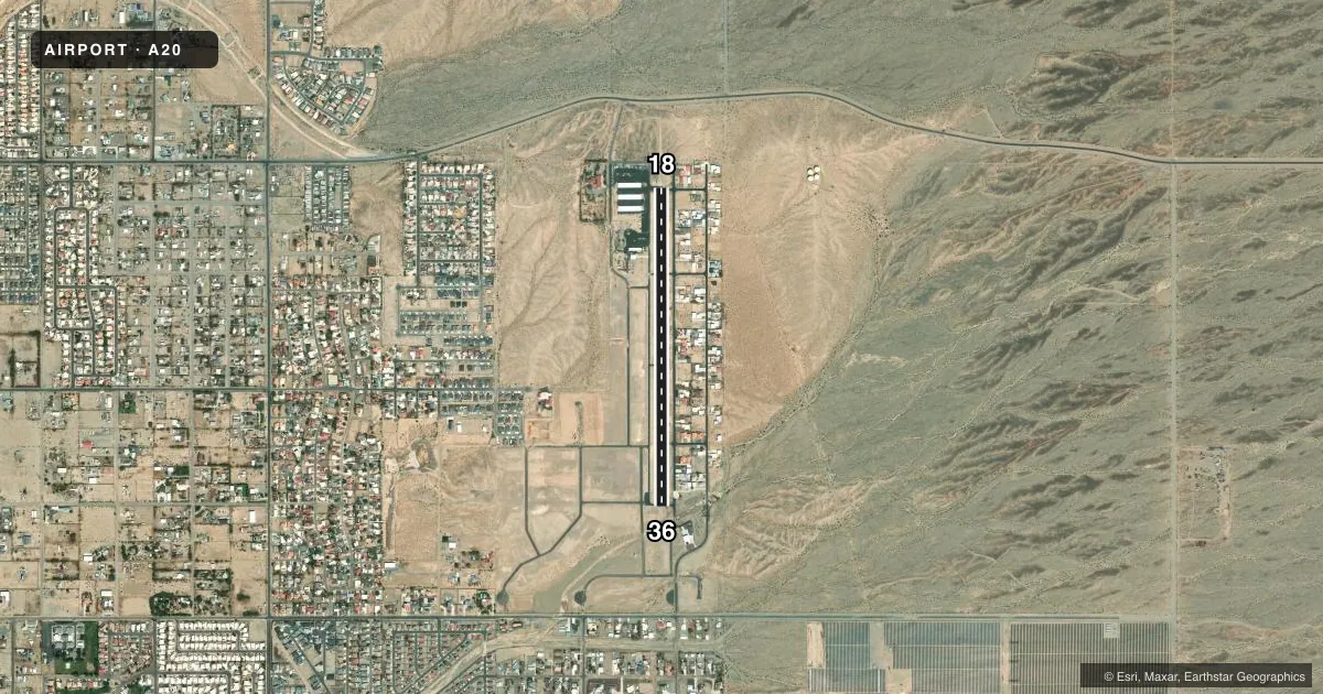
Airport sketch
Runways drawn to scale from FAA survey coordinates, rendered over satellite imagery. Not for navigation.
Approaches & charts
Services on the field
Fuel grades, oxygen, maintenance, ramp storage and lighting — as declared to the FAA by the airport operator.
Fuel & services
- Fuel
- 100LLA
- Other services
- INSTR,RNTL
Ramp & ground
- Transient storage
- Hangar
- Landing fee
- No fee published
- Lighting schedule
- SEE RMK
- Beacon schedule
- SS-SR
- Beacon
- White / Green (civil land)(WG)
- Wind indicator
- Lighted
- Segmented circle
- Yes
Fuel & FBOs
Cheapest 100LL and Jet A on the field and nearby. Always confirm with the FBO before taxi.
Airport notes
Surface conditions, obstructions, local procedures, lighting outages and other notes published with each FAA cycle.
General notes
- ALL OPS RMN E; SI OR DEP NA.
- FOR CD CTC LOS ANGELES ARTCC AT 661-575-2079.
- SELF SVC FUEL H24 WITH CREDIT CARD.
Lighting notes
- ACTVT LIRL RWY 18/36 - CTAF.
Runway surface & condition
- 18/36+2-6 FT BRUSH 35 FT E OF CNTRLN FULL LEN. DRAINAGE SWALE 25 FT LONG 40 FT R OF RWY FULL LEN.
Approach & departure obstructions
- 182-3 FT BRUSH 50-200 FT FM THR 40-125 FT R & L OF CNTRLN. 4 FT DIRT PILES 125-200 FT FM THR 75 FT R OF CNTRLN.
- 361-2 FT BRUSH 20-200 FT FM RWY END ACRS CNTRLN.
- 18NSTD LEN & WID.
- 36NSTD LEN & WID.
- 36NON STD; SINGLE UNIT RED & WHITE LGTS L SIDE OF RWY; 3 DEG.
Other notes
- VFR ONLY.
- AVBLTY - AMGR.
- FEE.
VFR map & nearby airports
VFR sectional. Tap any ICAO chip to open that airport.
Key facts · A20
Answer card- ICAO
- A20
- Name
- SUN VALLEY
- Location
- BULLHEAD CITY, ARIZONA
- Elevation
- 725 ft MSL
- Traffic pattern altitude
- 1,725 ft MSL (1,000 AGL)
- Control tower
- Non-towered (use CTAF)
- Total runways
- 1
- Longest runway
- 18/36 · 3,700 ft
- Published ILS approaches
- 0
- Published frequencies
- 2
- Magnetic variation
- 14°
- Current flight rules
- VFR
- Current wind
- 220° at 15 kt
- Favored runway now
- RWY 18
Sun Valley Airport (A20) is in Bullhead City, Arizona. The field elevation is 725 ft MSL. It has one runway. Runway 18/36 is 3,700 ft long and asphalt. There is no control tower, so use CTAF 122.975 for traffic and for runway light activation. No ILS approaches are published here. The pattern altitude is not published. Use the standard 1,000 ft AGL pattern unless the current Chart Supplement says otherwise, which puts the pattern at 1,725 ft MSL based on the field elevation.
This is a VFR-only field. Published remarks say all operations remain east. Straight-in and departure operations are not authorized. Runway 36 has a nonstandard visual glide slope indicator on the left side of the runway. Runway 18 has nonstandard length and width markings. Brush and dirt piles are reported near the threshold area. Brush also runs close to the runway edge for much of the length. That makes a careful stabilized approach important here. Sun Valley Airport is the on-field FBO. It carries AVGAS 100LL and JET A. Self-serve fuel is available 24 hours with credit card. There is also a fee for transient tie-down storage. For clearance delivery, contact Los Angeles ARTCC. Check the current Chart Supplement before flight for the latest operational notes.