METAR & TAF KEED
Current METAR
Observed 08:56Z
KEED 270856Z AUTO 18011KT 10SM CLR 37/13 A2981 RMK AO2 SLP051 T03670133 51001 $
- Wind
- 180° @ 11 kt
- Visibility
- 10 SM
- Temp / Dew
- 37°C / 13°C
- Altimeter
- 29.81 inHg
- Clouds
- CLR
- Density alt
- 3,995 ft
- Ceiling
- Unlimited
- Rules
- VFR
Airport info & contacts
Manager on record, flight service, ARTCC, attendance schedule and pattern altitude — published by the FAA and refreshed every 28 days.
Location
- From city
- 5 NM S
- VFR sectional
- PHOENIX
- ARTCC
- ZLA · LOS ANGELES
- NOTAM facility
- EED (NOTAM-D)
Airport manager
- Name
- TESS COOK
- Phone
- 909-327-8740
- Address
- 711 AIRPORT RD, NEEDLES CA 92363
Flight service · Hours
- FSS RAL
- RIVERSIDE1-800-WX-BRIEF
- Attendance
- Unattended
Frequencies
Tap any row to copy the frequency to your clipboard.
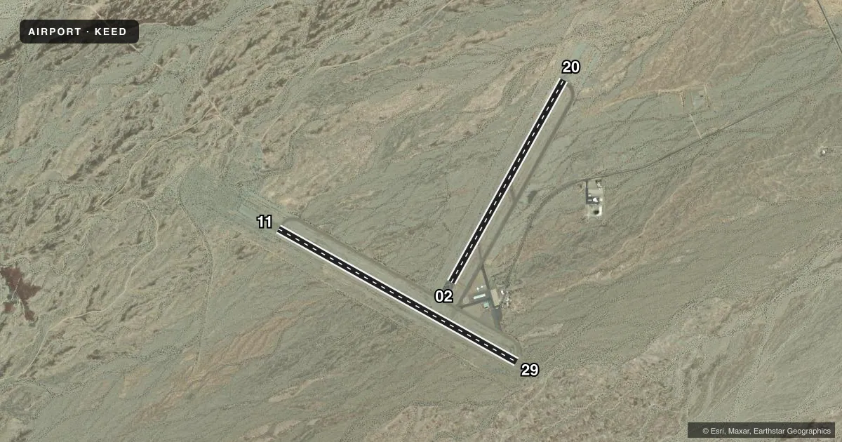
Runways & pattern
Full pagePattern entry · RWY 20
LEFT TRAFFIC| Runway | Heading (°M) | Length | Surface | Traffic |
|---|---|---|---|---|
| 11/29 | 105° / 285° | 5,005 ft | ASPH | Standard L |
| 02/20Favored | 15° / 195° | 4,235 ft | ASPH | Standard L |
Runway end performance
| End | TORA | TODA | ASDA | LDA | VGSI | Approach lights | Obstruction |
|---|---|---|---|---|---|---|---|
| 11 | — | — | — | — | PAPI 2-box left(3°) | — | — |
| 29 | — | — | — | — | PAPI 2-box left(3°) | — | — |
| 02 | — | — | — | — | PAPI 2-box left(3°) | — | — |
| 20 | — | — | — | — | PAPI 2-box left(3°) | — | — |
Declared distances in feet. TORA = takeoff run available, TODA = takeoff distance, ASDA = accelerate-stop, LDA = landing distance.
Airport sketch
Runways drawn to scale from FAA survey coordinates, rendered over satellite imagery. Not for navigation.
Approaches & charts
Services on the field
Fuel grades, oxygen, maintenance, ramp storage and lighting — as declared to the FAA by the airport operator.
Fuel & services
- Fuel
- 100LLA
- Oxygen (bottled)
- Not available
- Oxygen (bulk)
- Not available
- Airframe repair
- Minor
- Power plant repair
- Minor
Ramp & ground
- Transient storage
- Tie-down
- Landing fee
- No fee published
- Customs
- Not available
- Lighting schedule
- SEE RMK
- Beacon schedule
- SS-SR
- Beacon
- White / Green (civil land)(WG)
- Wind indicator
- Lighted
- Segmented circle
- Yes
Fuel & FBOs
Cheapest 100LL and Jet A on the field and nearby. Always confirm with the FBO before taxi.
Airport notes
Surface conditions, obstructions, local procedures, lighting outages and other notes published with each FAA cycle.
General notes
- <UNLGTD MTN WEST & SOUTH OF ARPT APRX 3200' MSL.
- (E81) 2 LGTS EACH SIDE MARKING RWY EXITS; REFLECTORS MARKING TWYS.
- FOR CD IF UNA TO CTC ON FSS FREQ, CTC LOS ANGELES ARTCC AT 661-575-2079.
Lighting notes
- ACTVT MIRL RY 11/29 & RY 02/20, REIL RY 11& RY 29 - CTAF. PAPI RY 11, RY 29, RY 02 & RY 20 OPER CONTINUOUSLY.
Fuel notes
- 100LL100LL FUEL AVBL 24 HRS SELF SRV
- AJET A FUEL AVBL 24 HRS SELF SVC
Approach & departure obstructions
- 29NSTD MARKINGS FOR INSTR APCH; BSC INSTEAD OF NPI MARKINGS.
Other notes
- ESTABD PRIOR TO 5/15/59.
- 02/20CRACKS IN PAVEMENT.
- 11/29CRACKS IN PAVEMENT
VFR map & nearby airports
VFR sectional. Tap any ICAO chip to open that airport.
Key facts · KEED
Answer card- ICAO
- KEED
- Name
- NEEDLES
- Location
- NEEDLES, CALIFORNIA
- Elevation
- 983.1 ft MSL
- Traffic pattern altitude
- 1,983.1 ft MSL (1,000 AGL)
- Control tower
- Non-towered (use CTAF)
- Total runways
- 2
- Longest runway
- 11/29 · 5,005 ft
- Published ILS approaches
- 0
- Published frequencies
- 2
- Magnetic variation
- 14°
- Current flight rules
- VFR
- Current wind
- 180° at 11 kt
- Favored runway now
- RWY 20
Needles Airport sits in Needles, California at 983.1 ft MSL. It has two asphalt runways. The longest is 11/29 at 5,005 ft. The other runway is 02/20 at 4,235 ft. This is an uncontrolled field with CTAF and UNICOM both on 123.0. No ILS approaches are published here.
Pattern altitude is not published. Use 1,000 ft AGL for light piston traffic unless local procedures or the current Chart Supplement say otherwise. The airport has medium intensity runway lights on both runways. Runway end identifier lights on 11 and 29 are controlled by CTAF. PAPI is listed for all runway ends. The field also has 24-hour self-serve 100LL and Jet A through Paradise Aviation, which is the on-field FBO. Call them at (760) 326-5263 for current ramp or fuel details.
For a first-time arrival, the big item is terrain. Unlighted mountains sit west and south of the airport at about 3,200 ft MSL. Expect a hot desert environment and plan your descent and pattern work with that in mind. Runway 02/20 has cracks in the pavement. Runway 11/29 also has cracks in the pavement. Runway 29 has basic markings instead of nonprecision instrument markings. If you need clearance delivery and cannot reach flight service, contact Los Angeles ARTCC at 661-575-2079.