METAR & TAF 1L4
1L4 does not publish a METAR.
Showing the nearest reporting station: KIFP (LAUGHLIN/BULLHEAD INTL) · 18.3 NM away. Conditions at 1L4 may differ.
METAR · KIFP
Observed 23:48Z
KIFP 262348Z 22015KT 10SM CLR 46/09 A2973
- Wind
- 220° @ 15 kt
- Visibility
- 10 SM
- Temp / Dew
- 46°C / 9°C
- Altimeter
- 29.73 inHg
- Clouds
- CLR
- Density alt
- 7,182 ft
- Ceiling
- Unlimited
- Rules
- VFR
Airport info & contacts
Manager on record, flight service, ARTCC, attendance schedule and pattern altitude — published by the FAA and refreshed every 28 days.
Location
- From city
- 0 NM S
- VFR sectional
- PHOENIX
- ARTCC
- ZLA · LOS ANGELES
- NOTAM facility
- RNO (NOTAM-D)
Airport manager
- Name
- MILNE POCOCK
- Phone
- 928-460-3987
- Address
- BUSH-AIR LLC, 20 COMANCHE TRAIL # 519, CAL-NEV-ARI NV 89039
Flight service · Hours
- FSS RNO
- RENO1-800-WX-BRIEF
- Attendance
- ALL
Frequencies
Tap any row to copy the frequency to your clipboard.
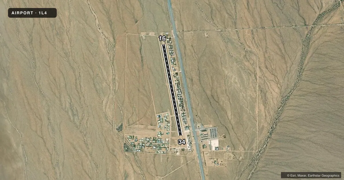
Runways & pattern
Full pagePattern entry · RWY 16
LEFT TRAFFICRunway end performance
| End | TORA | TODA | ASDA | LDA | VGSI | Approach lights | Obstruction |
|---|---|---|---|---|---|---|---|
| 16 | — | — | — | — | — | — | 5', fence, 10' from thr, 0' R of cntrln, slope 2 |
| 34 | — | — | — | — | — | — | 15', road, 560' from thr, 0' R of cntrln, slope 37 |
Declared distances in feet. TORA = takeoff run available, TODA = takeoff distance, ASDA = accelerate-stop, LDA = landing distance.
Airport sketch
Runways drawn to scale from FAA survey coordinates, rendered over satellite imagery. Not for navigation.
Approaches & charts
Services on the field
Fuel grades, oxygen, maintenance, ramp storage and lighting — as declared to the FAA by the airport operator.
Fuel & services
- Fuel
- Not available
- Airframe repair
- Not available
- Power plant repair
- Not available
- Other services
- INSTR
Ramp & ground
- Transient storage
- Tie-down
- Landing fee
- No fee published
- Customs
- Not available
- Lighting schedule
- SS-SR
- Wind indicator
- Yes
- Segmented circle
- No
Fuel & FBOs
Cheapest 100LL and Jet A on the field and nearby. Always confirm with the FBO before taxi.
Airport notes
Surface conditions, obstructions, local procedures, lighting outages and other notes published with each FAA cycle.
General notes
- RESIDENTIAL AIRPARK.
- WEST TWY NOT MNTND; LRG ROCKS & 6 FT BRUSH ON EDGES; USE AT YOUR OWN RISK.
- FOR CD CTC LOS ANGELES ARTCC AT 661-575-2079.
- CTN: AUTOMOBILE TFC ON RWY.
- AEROBATIC PRACTICE AREA WEST OF ARPT GND TO 5000 FT AGL. ACTVT BY NOTAM.
- OCNL NGT LASERS AND PYRO DSPL FM ACFT. ACTVT BY NOTAM.
Runway surface & condition
- 16/34PAT TFC USE CTN: 80 FT UNLGTD POLE 500 FT EAST OF RWY 34 THR PENETRATES TRSN AREA; 7:1 OCS TO RWY ALG HWY.
- 16/34NON-STD, PCL INSTALLED IN SOME TD AREAS.
Approach & departure obstructions
- 1670 FT TWR 350 FT L OF CNTRLN ADJ TO THR.
- 16TIRES INDC DSRD TD POINTS, ADDNL MARKINGS AND CONES ADDED FOR FLT TRNG PURPOSES.
- 34TIRES INDC DSRD TD POINTS, ADDNL MARKINGS & CONES ADDED FOR FLT TRNG PURPOSES.
- 16TIRES USED TO MARK TD POINTS.
- 34TIRES USED TO MARK TD POINTS.
Other notes
- 16/34PACKED SAND & GRVL; EDGES & ENDS SOFT SAND IN DRY CONDS; EDGES BURMED WITH 12 - 36 IN SOIL; 5 FT BRUSH IN RWY SAFETY AREA & UP TO EDGES.
VFR map & nearby airports
VFR sectional. Tap any ICAO chip to open that airport.
Key facts · 1L4
Answer card- ICAO
- 1L4
- Name
- KIDWELL
- Location
- CAL NEV ARI, NEVADA
- Elevation
- 2,602 ft MSL
- Traffic pattern altitude
- 3,602 ft MSL (1,000 AGL)
- Control tower
- Non-towered (use CTAF)
- Total runways
- 1
- Longest runway
- 16/34 · 4,140 ft
- Published ILS approaches
- 0
- Published frequencies
- 1
- Magnetic variation
- 14°
- Current flight rules
- VFR
- Current wind
- 220° at 15 kt
- Favored runway now
- RWY 16
KIDWELL is in Cal Nev Ari, Nevada. The field elevation is 2,602 ft MSL. It has one runway. Runway 16/34 is 4,140 ft long and the surface is sand. There is no control tower. CTAF is 122.9. No ILS approaches are published.
Pattern altitude is not published. Use 3,602 ft MSL as the standard 1,000 ft AGL pattern altitude for light piston traffic unless the current Chart Supplement or local procedures say otherwise. The published remarks matter here. The runway has packed sand and gravel with soft sand at the edges in dry conditions. The runway safety area has brush up to 5 ft. There is also an 80 ft unlighted pole east of runway 34 and a 70 ft tower left of runway 16 near the threshold. Tires and cones mark touchdown points on both ends.
This is a residential airpark. Expect local traffic and use extra caution for automobile traffic on the runway. The west taxiway is not maintained. It has large rocks and brush on the edges. Non-standard runway lighting is installed with pilot-controlled lighting in some touchdown areas. Occasional night lasers and pyrotechnic displays from aircraft are activated by NOTAM. There are no on-field FBOs listed. Check the current FAA Chart Supplement and contact the airport operator before you go.