METAR & TAF 1L3
1L3 does not publish a METAR.
Showing the nearest reporting station: KIFP (LAUGHLIN/BULLHEAD INTL) · 24.4 NM away. Conditions at 1L3 may differ.
METAR · KIFP
Observed 23:48Z
KIFP 262348Z 22015KT 10SM CLR 46/09 A2973
- Wind
- 220° @ 15 kt
- Visibility
- 10 SM
- Temp / Dew
- 46°C / 9°C
- Altimeter
- 29.73 inHg
- Clouds
- CLR
- Density alt
- 8,188 ft
- Ceiling
- Unlimited
- Rules
- VFR
Airport info & contacts
Manager on record, flight service, ARTCC, attendance schedule and pattern altitude — published by the FAA and refreshed every 28 days.
Location
- From city
- 1 NM SSE
- VFR sectional
- PHOENIX
- ARTCC
- ZLA · LOS ANGELES
- NOTAM facility
- RNO (NOTAM-D)
Airport manager
- Name
- RUTHANN GRANITO
- Phone
- 917-608-5778
- Address
- GRANITO LTD, 2614 CROYDON RD., CHARLOTTE NC 28209
Flight service · Hours
- FSS RNO
- RENO1-800-WX-BRIEF
- Attendance
- Unattended
Frequencies
Tap any row to copy the frequency to your clipboard.
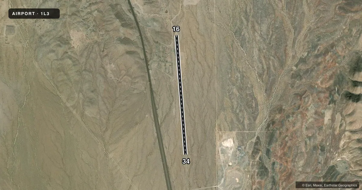
Runways & pattern
Full pagePattern entry · RWY 16
LEFT TRAFFICRunway end performance
| End | TORA | TODA | ASDA | LDA | VGSI | Approach lights | Obstruction |
|---|---|---|---|---|---|---|---|
| 16 | — | — | — | — | — | — | 5', fence, 275' from thr, 0' R of cntrln, slope 15 |
| 34 | — | — | — | — | — | — | 5', brush, 200' from thr, 0' R of cntrln, slope 0 |
Declared distances in feet. TORA = takeoff run available, TODA = takeoff distance, ASDA = accelerate-stop, LDA = landing distance.
Airport sketch
Runways drawn to scale from FAA survey coordinates, rendered over satellite imagery. Not for navigation.
Approaches & charts
Services on the field
Fuel grades, oxygen, maintenance, ramp storage and lighting — as declared to the FAA by the airport operator.
Fuel & services
- Fuel
- Not available
Ramp & ground
- Transient storage
- Tie-down
- Landing fee
- Yes
- Wind indicator
- No
- Segmented circle
- No
Fuel & FBOs
Cheapest 100LL and Jet A on the field and nearby. Always confirm with the FBO before taxi.
Airport notes
Surface conditions, obstructions, local procedures, lighting outages and other notes published with each FAA cycle.
General notes
- 3481 FT LGTD MTN SW.
- UNLGTD 165 FT PLINE 3.2 MI SOUTH OF RWY.
- TRRN RISES CNSTNT RATE N FOR 2 MI.
- ARPT COND NOT MNTD - RWY CLSD FOR REPAIRS INDEFLY.
- FOR CD CTC LOS ANGELES ARTCC AT 661-575-2079.
- PPR FOR PVT ARPT AREA USE OR INFO - AMGR.
- RWY 16/34 CLSD INDEFLY.
Approach & departure obstructions
- 165 FT FENCE 83 FT L & PARL TO CNTRLN.
- 342-4 FT BRUSH S END OF RWY IN RSA.
- H1TLOF 46X46 FT; FATO 85X85 FT; INGRESS/EGRESS 340/160.
- H2TLOF 46X46 FT; FATO 85X85 FT; INGRESS/EGRESS 340/160.
- 16MKGS FADED & BRUSH CVRD.
- 34MKGS FADED & BRUSH CVRD.
Other notes
- ESTABD PRIOR TO 15 MAY 1959. APPROVED IAW ASN 2020-AWP-1742-NRA.
- 16/34CRACKS IN ASPH.
VFR map & nearby airports
VFR sectional. Tap any ICAO chip to open that airport.
Key facts · 1L3
Answer card- ICAO
- 1L3
- Name
- SEARCHLIGHT
- Location
- SEARCHLIGHT, NEVADA
- Elevation
- 3,413 ft MSL
- Traffic pattern altitude
- 4,413 ft MSL (1,000 AGL)
- Control tower
- Non-towered (use CTAF)
- Total runways
- 1
- Longest runway
- 16/34 · 5,040 ft
- Published ILS approaches
- 0
- Published frequencies
- 1
- Magnetic variation
- 14°
- Current flight rules
- VFR
- Current wind
- 220° at 15 kt
- Favored runway now
- RWY 16
Searchlight Airport sits in Searchlight, Nevada. The field elevation is 3,413 ft MSL. It has one runway, 16/34, which is 5,040 ft long on asphalt. No tower is published. CTAF is 122.9. No ILS approaches are published.
The pattern altitude is not published. For light piston operations, use 1,000 ft AGL unless the current Chart Supplement or airport operator says otherwise. The airport sits in higher desert terrain. Terrain rises steadily to the north for 2 miles. There is also a lighted mountain southwest of the field. That matters for climb performance and departure planning.
Published remarks say runway 16/34 is closed indefinitely. The airport condition is not maintained. There are cracks in the asphalt. Brush is reported in the runway safety area at the south end. A five-foot fence sits left of the runway 16 end. Markings at the 34 end are faded and brush covered. Prior permission is required for private airport area use or information. Contact the airport manager before planning any arrival. No on-field FBOs are listed. Check with the airport operator or the FBO directly by phone for current service status before you go.