METAR & TAF 3L2
3L2 does not publish a METAR.
Showing the nearest reporting station: KHND (HENDERSON EXEC) · 26.3 NM away. Conditions at 3L2 may differ.
METAR · KHND
Observed 03:56Z
KHND 270356Z AUTO 21009KT 10SM CLR 36/09 A2992 RMK AO2 SLP109 T03610094 $
- Wind
- 210° @ 9 kt
- Visibility
- 10 SM
- Temp / Dew
- 36°C / 9°C
- Altimeter
- 29.92 inHg
- Clouds
- CLR
- Density alt
- 5,743 ft
- Ceiling
- Unlimited
- Rules
- VFR
Airport info & contacts
Manager on record, flight service, ARTCC, attendance schedule and pattern altitude — published by the FAA and refreshed every 28 days.
Location
- From city
- 2 NM SW
- VFR sectional
- LAS VEGAS
- ARTCC
- ZLA · LOS ANGELES
- NOTAM facility
- RNO (NOTAM-D)
Airport manager
- Name
- STEVE VAN FRANK
- Phone
- 702-420-3559
- Address
- 838 SARATOGA AVENUE, SANDY VALLEY NV 89019-8623
Flight service · Hours
- FSS RNO
- RENO1-800-WX-BRIEF
- Attendance
- IREG
Frequencies
Tap any row to copy the frequency to your clipboard.
Runways & pattern
Full pagePattern entry · RWY 12
RIGHT TRAFFICAirport sketch
Runways drawn to scale from FAA survey coordinates, rendered over satellite imagery. Not for navigation.
Approaches & charts
Services on the field
Fuel grades, oxygen, maintenance, ramp storage and lighting — as declared to the FAA by the airport operator.
Fuel & services
- Fuel
- Not available
Ramp & ground
- Transient storage
- Tie-down
- Hangar
- Landing fee
- No fee published
- Wind indicator
- Yes
- Segmented circle
- Yes
Fuel & FBOs
Cheapest 100LL and Jet A on the field and nearby. Always confirm with the FBO before taxi.
Airport notes
Surface conditions, obstructions, local procedures, lighting outages and other notes published with each FAA cycle.
General notes
- AVOID NOISE SENSITIVE RESIDENTIAL AREA 1.5 MILES NE OF ARPT.
- LOW FLYING MILITARY AIRCRAFT IN AREA.
- UNMARKED & UNLIGHTED POWER POLES/LINES NW/SE OF RWY 03/21.
- ARPT IS A RESIDENTIAL AIRPARK; AUTO TRAFFIC IS ON & ACROSS RWYS & TWYS.
- OCNL WILD HORSES ON AND INVOF ACFT MOV AREAS.
- RY 03/21 OBSTACLE FREE AREA LIMITED TO 96 FT EITHER SIDE OF RY CNTRLN.
- NO LINE OF SIGHT BTWN RY ENDS.
- ULTRALIGHT ACTIVITY ON AND IN VICINTY OF AIRPORT.
- FOR CD CTC LAS VEGAS APCH AT 725-200-4432.
Runway surface & condition
- 12/30RY 12/30 THLD NOT MARKED.
- 03/21RWY 03/21 RTHL ONLY. RWY EDGES MARKED WITH REFLECTORS.
Approach & departure obstructions
- 21+16 FT ROAD, 0-200 FT FROM RWY END, 125 FT R TO OB. +4 FT FENCE, 0-200 FT FROM RWY END, 108 FT R TO OB.
- 21DSPLCD THLD MARKED WITH 8 FT WHITE LINE.
- 21+16 FT ROAD, DIST 172 FT, 118 FT R, 10:1 BASED ON DSPLCD THR.
VFR map & nearby airports
VFR sectional. Tap any ICAO chip to open that airport.
Key facts · 3L2
Answer card- ICAO
- 3L2
- Name
- SKY RANCH
- Location
- SANDY VALLEY, NEVADA
- Elevation
- 2,599 ft MSL
- Traffic pattern altitude
- 3,599 ft MSL (1,000 AGL)
- Control tower
- Non-towered (use CTAF)
- Total runways
- 1
- Longest runway
- 12/30 · 3,300 ft
- Published ILS approaches
- 0
- Published frequencies
- 2
- Magnetic variation
- 14°
- Current flight rules
- VFR
- Current wind
- 210° at 9 kt
- Favored runway now
- RWY 12
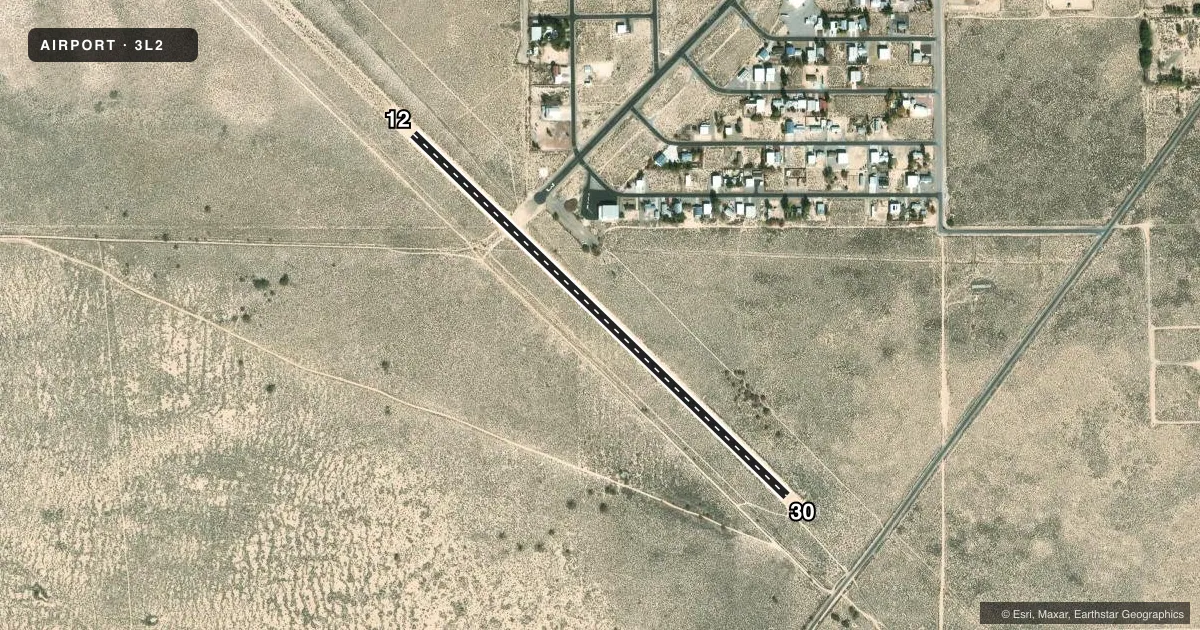
Sky Ranch (3L2) sits in Sandy Valley, Nevada. The field elevation is 2,599 ft MSL. It has one runway. Runway 12/30 is 3,300 ft long and dirt. The runway headings are 134° and 314° magnetic. No tower is on the field. CTAF and UNICOM are both 123.0.
No ILS approaches are published here. Pattern altitude is not published, so use the current FAA Chart Supplement before you fly. For light piston traffic, a standard 1,000 ft AGL pattern would put you at 3,599 ft MSL at this field. Verify the published pattern before arrival.
This is a residential airpark. Automobile traffic is on and across runways and taxiways. Expect occasional wild horses near the movement areas. Low flying military aircraft are also reported in the area. There is no line of sight between runway ends. Runway 12/30 threshold is not marked. The published remarks also call out a noise-sensitive residential area 1.5 miles northeast of the airport. Plan your arrival and departure with that in mind. There are no on-field FBOs listed. Contact the airport operator directly or call the field on CTAF for current fuel and service availability before you go.