METAR & TAF L61
L61 does not publish a METAR.
Showing the nearest reporting station: KVGT (NORTH LAS VEGAS) · 54.1 NM away. Conditions at L61 may differ.
METAR · KVGT
Observed 06:53Z
KVGT 270653Z AUTO 18009KT 10SM CLR 36/08 A2986 RMK AO2 SLP092 T03610078
- Wind
- 180° @ 9 kt
- Visibility
- 10 SM
- Temp / Dew
- 36°C / 8°C
- Altimeter
- 29.86 inHg
- Clouds
- CLR
- Density alt
- 4,539 ft
- Ceiling
- Unlimited
- Rules
- VFR
Airport info & contacts
Manager on record, flight service, ARTCC, attendance schedule and pattern altitude — published by the FAA and refreshed every 28 days.
Location
- From city
- 1 NM S
- VFR sectional
- LAS VEGAS
- Pattern altitude
- 800 ft AGL · 2,368 ft MSL
- ARTCC
- ZLA · LOS ANGELES
- NOTAM facility
- RAL (NOTAM-D)
Airport manager
- Name
- ASHLEY HELMS
- Phone
- 760-872-2971
- Address
- 703 AIRPORT ROAD, BISHOP CA 93514
Flight service · Hours
- FSS RAL
- RIVERSIDE1-800-WX-BRIEF
- Attendance
- Unattended
Frequencies
Tap any row to copy the frequency to your clipboard.
Runways & pattern
Full pagePattern entry · RWY 15
LEFT TRAFFICRunway end performance
| End | TORA | TODA | ASDA | LDA | VGSI | Approach lights | Obstruction |
|---|---|---|---|---|---|---|---|
| 15 | — | — | — | — | — | — | 30', trees, 600' from thr, 100' R of cntrln, slope 13 |
| 33 | — | — | — | — | — | — | 7', berm, 200' from thr, 115' R of cntrln, slope 0 |
Declared distances in feet. TORA = takeoff run available, TODA = takeoff distance, ASDA = accelerate-stop, LDA = landing distance.
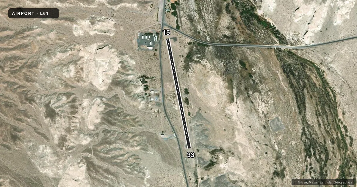
Airport sketch
Runways drawn to scale from FAA survey coordinates, rendered over satellite imagery. Not for navigation.
Approaches & charts
Services on the field
Fuel grades, oxygen, maintenance, ramp storage and lighting — as declared to the FAA by the airport operator.
Fuel & services
- Fuel
- Not available
- Oxygen (bottled)
- Not available
- Oxygen (bulk)
- Not available
- Airframe repair
- Not available
- Power plant repair
- Not available
Ramp & ground
- Transient storage
- Tie-down
- Landing fee
- No fee published
- Lighting schedule
- SEE RMK
- Beacon schedule
- SEE RMK
- Wind indicator
- Lighted
- Segmented circle
- Yes
Fuel & FBOs
Cheapest 100LL and Jet A on the field and nearby. Always confirm with the FBO before taxi.
Airport notes
Surface conditions, obstructions, local procedures, lighting outages and other notes published with each FAA cycle.
General notes
- OBSTNS PART 77 MTNS N OF ARPT, P-LINE E OF RWY & HILL SE EOR.
- RY 15/33 CLSD TO HELICOPTERS.
- FOR CD CTC LOS ANGELES ARTCC AT 661-575-2079.
Lighting notes
- PCL IS OUT OF SVC. CONTACT STEVE LOVEN AT BISHOP ARPT 760-872-2971 DRG 0800-1600 M-F TO SKED AN EVENING LGTG TURN ON AT SHOSHONE PRIOR TO NGT USE.
- PCL IS OUT OF SVC. CTC STEVE LOVEN AT BISHOP ARPT 760-872-2971 DRG 0800-1600 M-F TO SKED AN EVENING LGTG TURN ON AT SHOSHONE PRIOR TO NGT USE.
Runway surface & condition
- 15/33RWY EDGE LGTS ARE MOUNTED ON SHORT 3-4 INCH STOUT NON-FRANGIBLE POSTS.
Approach & departure obstructions
- 15+15 FT ROAD 0 FT FM THLD 110 FT R TO 200 FT FM THLD 60 FT R.
- 33+7 FT BERM 0 FT FM THLD 125 FT R TO 200 FT FM THLD 115 FT R.
Other notes
- ESTABD PRIOR TO 5/15/59.
- MANAGERAFTER HRS EMERG NO. 760-937-4017
VFR map & nearby airports
VFR sectional. Tap any ICAO chip to open that airport.
Key facts · L61
Answer card- ICAO
- L61
- Name
- SHOSHONE
- Location
- SHOSHONE, CALIFORNIA
- Elevation
- 1,568 ft MSL
- Traffic pattern altitude
- 2,368 ft MSL (800 AGL)
- Control tower
- Non-towered (use CTAF)
- Total runways
- 1
- Longest runway
- 15/33 · 2,380 ft
- Published ILS approaches
- 0
- Published frequencies
- 1
- Magnetic variation
- 14°
- Current flight rules
- VFR
- Current wind
- 180° at 9 kt
- Favored runway now
- RWY 15
Shoshone Airport sits in Shoshone, California. Field elevation is 1,568 ft MSL. The airport has one runway, 15/33, which is 2,380 ft long and asphalt. There is no control tower. CTAF is 122.9. Pattern altitude is 800 ft AGL, which is 2,368 ft MSL.
No ILS approaches are published here. That matters if you are planning an IFR arrival. Check the current FAA Chart Supplement for the latest approach and airport notes before you go. The published remarks also call out terrain and obstacle issues. There are Part 77 mountains north of the airport. There is also a power line east of the runway. A hill sits near the southeast end of the runway. Runway 15 has a road close to the threshold. Runway 33 has a berm close to the threshold. Runway edge lights are on short non-frangible posts.
Pilot controlled lighting is out of service. For an evening lighting turn-on before night use, the published remarks direct pilots to contact Steve Loven at Bishop Airport during weekday business hours. Runway 15/33 is closed to helicopters. No on-field FBOs are listed, so contact the airport operator directly before arrival or call the field on CTAF for current service options. For clearance delivery, the remarks list Los Angeles ARTCC. This is a small desert field, so plan for terrain, limited runway length and close-in obstacles.