METAR & TAF L06
L06 does not publish a METAR.
Showing the nearest reporting station: KVGT (NORTH LAS VEGAS) · 82.9 NM away. Conditions at L06 may differ.
METAR · KVGT
Observed 05:53Z
KVGT 270553Z AUTO 18010KT 10SM CLR 36/08 A2986 RMK AO2 SLP091 T03610078 10406 20361 50005
- Wind
- 180° @ 10 kt
- Visibility
- 10 SM
- Temp / Dew
- 36°C / 8°C
- Altimeter
- 29.86 inHg
- Clouds
- CLR
- Density alt
- 2,334 ft
- Ceiling
- Unlimited
- Rules
- VFR
Airport info & contacts
Manager on record, flight service, ARTCC, attendance schedule and pattern altitude — published by the FAA and refreshed every 28 days.
Location
- From city
- 0 NM N
- VFR sectional
- LAS VEGAS
- ARTCC
- ZLA · LOS ANGELES
- NOTAM facility
- RAL (NOTAM-D)
Airport manager
- Name
- PHILIP JOHNSON
- Phone
- 760-786-3245
- Address
- DEATH VALLEY NATL PARK, DEATH VALLEY CA 92328
Flight service · Hours
- FSS RAL
- RIVERSIDE1-800-WX-BRIEF
- Attendance
- Unattended
Frequencies
Tap any row to copy the frequency to your clipboard.
Runways & pattern
Full pagePattern entry · RWY 15
RIGHT TRAFFICRunway end performance
| End | TORA | TODA | ASDA | LDA | VGSI | Approach lights | Obstruction |
|---|---|---|---|---|---|---|---|
| 15 | — | — | — | — | — | — | 15', brush, 210' from thr, 100' R of cntrln, slope 0 |
| 33 | — | — | — | — | — | — | 15', brush, 500' from thr, 130' R of cntrln, slope 20 |
Declared distances in feet. TORA = takeoff run available, TODA = takeoff distance, ASDA = accelerate-stop, LDA = landing distance.
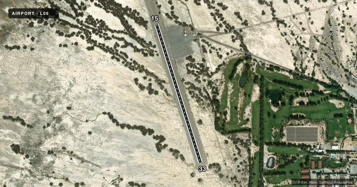
Airport sketch
Runways drawn to scale from FAA survey coordinates, rendered over satellite imagery. Not for navigation.
Approaches & charts
Services on the field
Fuel grades, oxygen, maintenance, ramp storage and lighting — as declared to the FAA by the airport operator.
Fuel & services
- Fuel
- Not available
- Oxygen (bottled)
- Not available
- Oxygen (bulk)
- Not available
- Airframe repair
- Not available
- Power plant repair
- Not available
Ramp & ground
- Transient storage
- Tie-down
- Landing fee
- No fee published
- Customs
- Not available
- Wind indicator
- Lighted
- Segmented circle
- Yes
Fuel & FBOs
Cheapest 100LL and Jet A on the field and nearby. Always confirm with the FBO before taxi.
Airport notes
Surface conditions, obstructions, local procedures, lighting outages and other notes published with each FAA cycle.
General notes
- USE ONLY MKD RY FOR GROUND OPNS. SAFETY AREA ROUGH & SOFT.
- NO TIEDOWN ROPES OR CHAINS AVBL.
- DITCH 145 FT RIGHT OF RY 33.
- SAFETY AREAS ADJ RY CLSD, STAY ON PAVED AREA ONLY DUE TO EXTREMELY SOFT DIRT.
- ARPT CLSD TO NIGHT OPS.
- FOR CD IF UNA TO CTC ON FSS FREQ, CTC LOS ANGELES ARTCC AT 661-575-2079.
- RWY 15/33 PAVEMENT HEAVING, EXTREMELY ROUGH SFC. POTENTIAL FOR DMG TO ACFT USING THIS RWY. NOT RCMDD FOR ACFT WITH WHEEL PANTS.
- CA STATE PMT HAS BEEN SUSPD UNTIL FURTHER NOTICE.
Other notes
- ESTABD PRIOR TO 5/15/59.
- ARPT LCTD 1 SM SW OF PARK HEADQUARTERS.
- MANAGERAIRPORT MANAGER IS A LAW ENFORCEMENT PARK RANGER, FOR EMERGENCIES CAN BE REACHED THROUGH PARK DISPATCH 760-786-2330
- 15/33UP TO 4 INCH SALT HEAVE ARND RWY CRACKS. COULD DMG ACFT WITH WHEEL FAIRINGS OR CAUSE A POTENTIAL TO BLOW OUT A TIRE.
VFR map & nearby airports
VFR sectional. Tap any ICAO chip to open that airport.
Key facts · L06
Answer card- ICAO
- L06
- Name
- FURNACE CREEK
- Location
- DEATH VALLEY NATIONAL PARK, CALIFORNIA
- Elevation
- -210 ft MSL
- Traffic pattern altitude
- 790 ft MSL (1,000 AGL)
- Control tower
- Non-towered (use CTAF)
- Total runways
- 1
- Longest runway
- 15/33 · 3,065 ft
- Published ILS approaches
- 0
- Published frequencies
- 1
- Magnetic variation
- 14°
- Current flight rules
- VFR
- Current wind
- 180° at 10 kt
- Favored runway now
- RWY 15
Furnace Creek Airport (L06) sits in Death Valley National Park in California. The field elevation is -210 ft MSL. It has one runway, 15/33, which is 3,065 ft long. There is no control tower. CTAF is 122.9. No ILS approaches are published.
Pattern altitude is not published. Use the standard 1,000 ft AGL for light piston operations unless the current FAA Chart Supplement says otherwise. The airport is 1 statute mile southwest of Park Headquarters. The published remarks matter here. Runway 15/33 has heaving pavement and an extremely rough surface. There is up to 4 inch salt heave around cracks. That can damage aircraft with wheel fairings or cause a tire blowout. Safety areas beside the runway are closed. Stay on paved surfaces only. There is also a ditch 145 feet right of runway 33.
No on-field FBOs are listed. No tiedown ropes or chains are available. The airport is closed to night operations. The airport manager is a law enforcement park ranger. For emergencies, contact park dispatch at 760-786-2330. California state permit has been suspended until further notice. For clearance delivery, if you cannot reach Flight Service Station, contact Los Angeles ARTCC at 661-575-2079. This is a place to plan carefully before arrival. Check the current FAA Chart Supplement for any updates before you go.