METAR & TAF L09
L09 does not publish a METAR.
Showing the nearest reporting station: KBIH (BISHOP) · 74.0 NM away. Conditions at L09 may differ.
METAR · KBIH
Observed 06:56Z
KBIH 270656Z AUTO 20008KT 10SM CLR 27/03 A3002 RMK AO2 SLP101 T02720028
- Wind
- 200° @ 8 kt
- Visibility
- 10 SM
- Temp / Dew
- 27°C / 3°C
- Altimeter
- 30.02 inHg
- Clouds
- CLR
- Density alt
- 1,347 ft
- Ceiling
- Unlimited
- Rules
- VFR
Airport info & contacts
Manager on record, flight service, ARTCC, attendance schedule and pattern altitude — published by the FAA and refreshed every 28 days.
Location
- From city
- 1 NM W
- VFR sectional
- LAS VEGAS
- Pattern altitude
- 800 ft AGL · 825 ft MSL
- ARTCC
- ZLA · LOS ANGELES
- NOTAM facility
- RAL (NOTAM-D)
Airport manager
- Name
- PHILIP JOHNSON
- Phone
- 760-786-3245
- Address
- DEATH VALLEY NATIONAL PARK, DEATH VALLEY CA 92328
Flight service · Hours
- FSS RAL
- RIVERSIDE1-800-WX-BRIEF
- Attendance
- Unattended
Frequencies
Tap any row to copy the frequency to your clipboard.
Runways & pattern
Full pagePattern entry · RWY 23
RIGHT TRAFFICRunway end performance
| End | TORA | TODA | ASDA | LDA | VGSI | Approach lights | Obstruction |
|---|---|---|---|---|---|---|---|
| 23 | — | — | — | — | — | — | 10', road, 420' from thr, 0' R of cntrln, slope 22 |
Declared distances in feet. TORA = takeoff run available, TODA = takeoff distance, ASDA = accelerate-stop, LDA = landing distance.
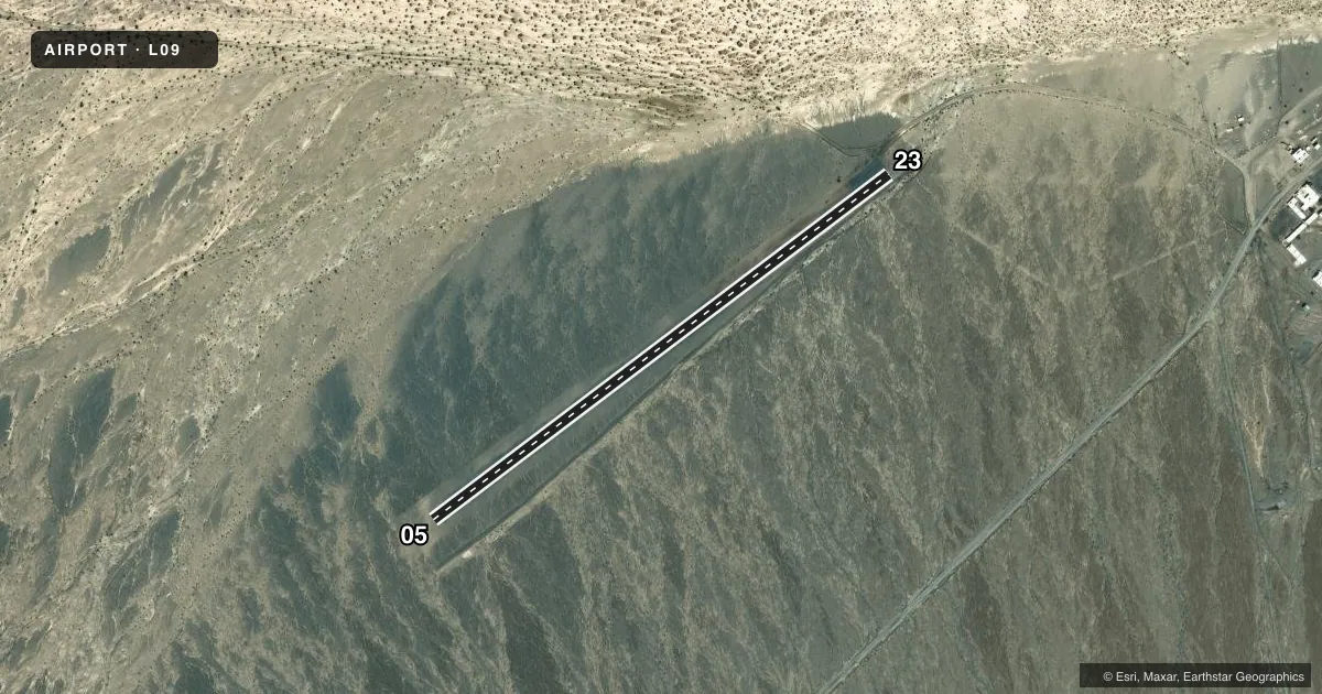
Airport sketch
Runways drawn to scale from FAA survey coordinates, rendered over satellite imagery. Not for navigation.
Approaches & charts
Services on the field
Fuel grades, oxygen, maintenance, ramp storage and lighting — as declared to the FAA by the airport operator.
Fuel & services
- Fuel
- Not available
Ramp & ground
- Transient storage
- Not published
- Landing fee
- No fee published
- Customs
- Not available
- Wind indicator
- Yes
- Segmented circle
- Yes
Fuel & FBOs
Cheapest 100LL and Jet A on the field and nearby. Always confirm with the FBO before taxi.
Airport notes
Surface conditions, obstructions, local procedures, lighting outages and other notes published with each FAA cycle.
General notes
- ACFT NEED TO BE PARKED AT LEAST 75 FT FROM RWY CNTRLN TO RMN OUT OF RWY SAFETY AREA.
- FOR CD CTC JOSHUA APCH AT 661-277-3843.
Approach & departure obstructions
- 23+4' DIKE 180' FM THR; +5' BRUSH 0' FM THR 40' R.
- 0505/23 CNTRLN IS SHORT DASHES.
Other notes
- MANAGERAIRPORT MANAGER IS A LAW ENFORCEMENT PARK RANGER, FOR EMERGENCIES CAN BE REACHED THROUGH PARK DISPATCH 760-786-2330
- MANAGERAFTER HOURS NUMBER 760-786-2330
- 05/23PAVEMENT IS IN POOR, BUT STBL COND.
VFR map & nearby airports
VFR sectional. Tap any ICAO chip to open that airport.
Key facts · L09
Answer card- ICAO
- L09
- Name
- STOVEPIPE WELLS
- Location
- DEATH VALLEY NATIONAL PARK, CALIFORNIA
- Elevation
- 25 ft MSL
- Traffic pattern altitude
- 825 ft MSL (800 AGL)
- Control tower
- Non-towered (use CTAF)
- Total runways
- 1
- Longest runway
- 05/23 · 3,260 ft
- Published ILS approaches
- 0
- Published frequencies
- 1
- Magnetic variation
- 14°
- Current flight rules
- VFR
- Current wind
- 200° at 8 kt
- Favored runway now
- RWY 23
Stovepipe Wells Airport (L09) sits in Death Valley National Park in California. Field elevation is 25 ft MSL. The airport has one runway, 05/23, which is 3,260 ft long. There is no control tower. CTAF is 122.9. No ILS approaches are published here.
Pattern altitude is 800 ft AGL, which is 825 ft MSL. That matters in the valley because the field is low, but the surrounding desert environment can still make density altitude a real planning item on warm days. Runway 05/23 centerline is marked with short dashes. The pavement is in poor but stable condition. On runway 23, watch the 4-foot dike 180 ft from the threshold. There is also a 5-foot brush obstacle near the threshold, 40 ft right of centerline.
There are no on-field FBOs listed. For clearance delivery, contact Joshua Approach at 661-277-3843. Park aircraft at least 75 ft from the runway centerline to stay clear of the runway safety area. If you need airport manager help after hours, use park dispatch at 760-786-2330. For a first-time arrival, treat this as a remote desert strip with limited services. Verify current airport notes with the FAA Chart Supplement before you go.