METAR & TAF 0L4
0L4 does not publish a METAR.
Showing the nearest reporting station: KTPH (TONOPAH) · 34.4 NM away. Conditions at 0L4 may differ.
METAR · KTPH
Observed 06:56Z
KTPH 270656Z AUTO 00000KT 10SM CLR 27/M02 A3015 RMK AO2 SLP107 T02721017
- Wind
- 000° @ 0 kt
- Visibility
- 10 SM
- Temp / Dew
- 27°C / -2°C
- Altimeter
- 30.15 inHg
- Clouds
- CLR
- Density alt
- 6,963 ft
- Ceiling
- Unlimited
- Rules
- VFR
Airport info & contacts
Manager on record, flight service, ARTCC, attendance schedule and pattern altitude — published by the FAA and refreshed every 28 days.
Location
- From city
- 14 NM S
- VFR sectional
- LAS VEGAS
- ARTCC
- ZLA · LOS ANGELES
- NOTAM facility
- RNO (NOTAM-D)
Airport manager
- Name
- TIMOTHY HIPP
- Phone
- (775) 485-3406
- Address
- P.O. BOX 517, GOLDFIELD NV 89013
Flight service · Hours
- FSS RNO
- RENO1-800-WX-BRIEF
- Attendance
- Unattended
Frequencies
Tap any row to copy the frequency to your clipboard.
Runways & pattern
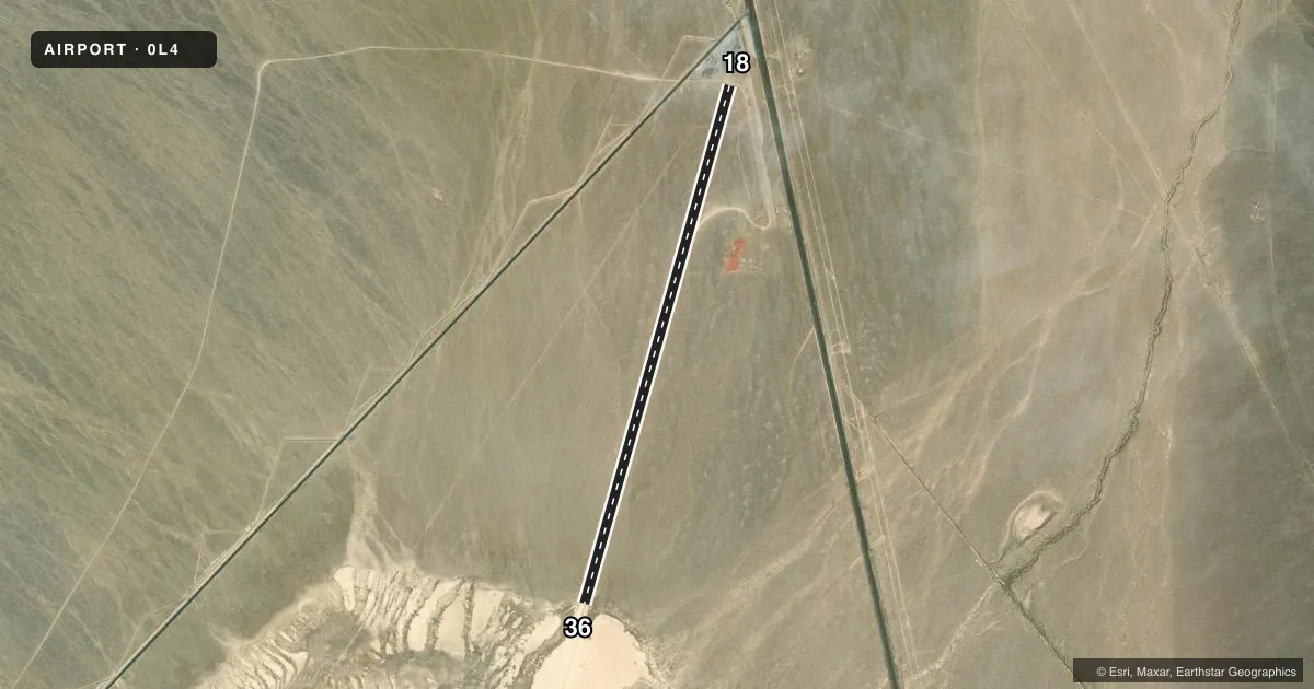
Full pagePattern entry · RWY 18
LEFT TRAFFICAirport sketch
Runways drawn to scale from FAA survey coordinates, rendered over satellite imagery. Not for navigation.
Approaches & charts
Services on the field
Fuel grades, oxygen, maintenance, ramp storage and lighting — as declared to the FAA by the airport operator.
Fuel & services
- Fuel
- Not available
Ramp & ground
- Transient storage
- Not published
- Landing fee
- No fee published
- Customs
- Not available
- Wind indicator
- No
- Segmented circle
- No
Fuel & FBOs
Cheapest 100LL and Jet A on the field and nearby. Always confirm with the FBO before taxi.
Airport notes
Surface conditions, obstructions, local procedures, lighting outages and other notes published with each FAA cycle.
General notes
- 30 FT UNLGT POLE 408 FT FM RWY 18 THR ON EXTDD CNTRLN.
- FOR CD CTC NELLIS APCH AT 702-652-4172.
Runway surface & condition
- 18/36UNCTLD VEHICLE & WILDLIFE INVOF RWY.
Approach & departure obstructions
- 18THR, TDZ & EDGES MKD WITH TIRES.
- 36THR, TDZ & EDGES MKD WITH TIRES.
Other notes
- PERM TIEDOWNS, FUEL, PHONE OR SVC NOT AVBL.
VFR map & nearby airports
VFR sectional. Tap any ICAO chip to open that airport.
Key facts · 0L4
Answer card- ICAO
- 0L4
- Name
- LIDA JUNCTION
- Location
- GOLDFIELD, NEVADA
- Elevation
- 4,684 ft MSL
- Traffic pattern altitude
- 5,684 ft MSL (1,000 AGL)
- Control tower
- Non-towered (use CTAF)
- Total runways
- 1
- Longest runway
- 18/36 · 6,100 ft
- Published ILS approaches
- 0
- Published frequencies
- 1
- Magnetic variation
- 15°
- Current flight rules
- VFR
- Current wind
- 000° at 0 kt
- Favored runway now
- –
Lida Junction Airport sits near Goldfield, Nevada. The field elevation is 4,684 ft MSL. It has one runway. Runway 18/36 is 6,100 ft long and dirt. There is no control tower. CTAF is 122.9. No ILS approaches are published here.
Pattern altitude is not published. Use 1,000 ft AGL as the standard light-piston pattern unless the current FAA Chart Supplement says otherwise. That puts the pattern at 5,684 ft MSL based on the listed field elevation. The runway headings in the facts are magnetic. Runway 18 is listed with a magnetic heading of 196°. Runway 36 is listed with a magnetic heading of 16°.
There are no on-field FBOs listed. Permanent tiedowns, fuel, phone, or service are not available, so plan to be self-sufficient. The published remarks also note a 30-foot unlighted pole 408 feet from the runway 18 threshold on the extended centerline. Wildlife and uncontrolled vehicle activity are also reported near the runway. Threshold, touchdown zone and edge markings on both ends are marked with tires. For clearance delivery, contact Nellis Approach at 702-652-4172. This is a high-elevation dirt strip in open country, so expect a different feel than a paved lowland airport. Check the current FAA Chart Supplement before you go.