METAR & TAF 1A8
1A8 does not publish a METAR.
Showing the nearest reporting station: KTPH (TONOPAH) · 21.5 NM away. Conditions at 1A8 may differ.
METAR · KTPH
Observed 06:56Z
KTPH 270656Z AUTO 00000KT 10SM CLR 27/M02 A3015 RMK AO2 SLP107 T02721017
- Wind
- 000° @ 0 kt
- Visibility
- 10 SM
- Temp / Dew
- 27°C / -2°C
- Altimeter
- 30.15 inHg
- Clouds
- CLR
- Density alt
- 8,119 ft
- Ceiling
- Unlimited
- Rules
- VFR
Airport info & contacts
Manager on record, flight service, ARTCC, attendance schedule and pattern altitude — published by the FAA and refreshed every 28 days.
Location
- From city
- 1 NM N
- VFR sectional
- LAS VEGAS
- ARTCC
- ZLA · LOS ANGELES
- NOTAM facility
- RNO
Airport manager
- Name
- TIMOTHY HIPP
- Phone
- 702-509-0059
- Address
- 207 WEST GRAND AVENUE, GOLDFIELD NV 89013
Flight service · Hours
- FSS RNO
- RENO1-800-WX-BRIEF
- Attendance
- Unattended
Frequencies
Tap any row to copy the frequency to your clipboard.
Runways & pattern
Full pagePattern entry · RWY 01
LEFT TRAFFICRunway end performance
| End | TORA | TODA | ASDA | LDA | VGSI | Approach lights | Obstruction |
|---|---|---|---|---|---|---|---|
| 01 | — | — | — | — | — | — | 110', hill, 3000' from thr |
| 19 | — | — | — | — | — | — | 5', sign, 185' from thr |
Declared distances in feet. TORA = takeoff run available, TODA = takeoff distance, ASDA = accelerate-stop, LDA = landing distance.
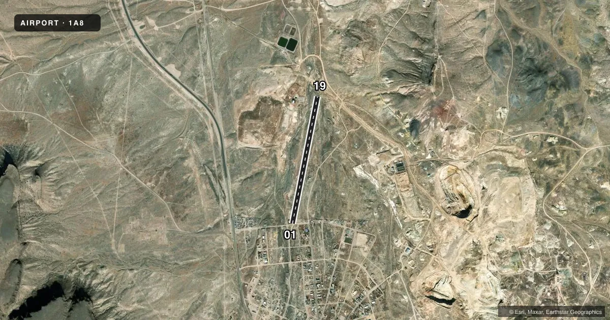
Airport sketch
Runways drawn to scale from FAA survey coordinates, rendered over satellite imagery. Not for navigation.
Approaches & charts
Services on the field
Fuel grades, oxygen, maintenance, ramp storage and lighting — as declared to the FAA by the airport operator.
Fuel & services
- Fuel
- Not available
- Contract fuel
- Not available
Ramp & ground
- Transient storage
- Not published
- Lighting schedule
- SS-SR
- Wind indicator
- No
- Segmented circle
- No
Fuel & FBOs
Cheapest 100LL and Jet A on the field and nearby. Always confirm with the FBO before taxi.
Airport notes
Surface conditions, obstructions, local procedures, lighting outages and other notes published with each FAA cycle.
General notes
- NGT OPS DISCOURAGED; MTS ALL QUADS.
- GND NORTH OF RWY 19 THR SLOPES DOWN 10 FT WITH GULLEYS LEFT & RIGHT; PLINES EAST OF RWY.
- EMS HELI ADJ TO RWY 01 THR.
- ARR UPHILL RWY 19; DEP DOWNHILL RWY 01.
- ARPT COND - 702-509-0059 OR AMGR.
Approach & departure obstructions
- 01INGRESS 170 DEGS / EGRESS 350 DEGS. TLOF 100 FT X 100 FT. FATO 100 FT X 100 FT.
- 1930 FT DROP 200 FT FM THR LEFT OF CNTRLN.
- 01WHITE TIRES.
- 19WHITE TIRES.
Other notes
- 01/19RUTS ON NORTH SIDE OF RWY.
VFR map & nearby airports
VFR sectional. Tap any ICAO chip to open that airport.
Key facts · 1A8
Answer card- ICAO
- 1A8
- Name
- GOLDFIELD
- Location
- GOLDFIELD, NEVADA
- Elevation
- 5,616 ft MSL
- Traffic pattern altitude
- 6,616 ft MSL (1,000 AGL)
- Control tower
- Non-towered (use CTAF)
- Total runways
- 1
- Longest runway
- 01/19 · 3,150 ft
- Published ILS approaches
- 0
- Published frequencies
- 1
- Magnetic variation
- –
- Current flight rules
- VFR
- Current wind
- 000° at 0 kt
- Favored runway now
- –
Goldfield Airport sits in Goldfield, Nevada at 5,616 ft MSL. It has one runway. Runway 01/19 is 3,150 ft of gravel. The field is not towered, so use CTAF 122.9 and keep your scan tight in the pattern. No ILS approaches are published here.
Pattern altitude is not published. Use the standard 1,000 ft AGL for light piston traffic unless the current Chart Supplement says otherwise. That puts the pattern at about 6,616 ft MSL. This is high desert country. Density altitude can get your attention fast. The published remarks also call out mountains in all quadrants, so night operations are discouraged.
There are no on-field FBOs listed. Check with the airport operator or the field directly before arrival if you need current services. The published remarks also note uphill arrivals on runway 19 and downhill departures on runway 01. Runway 19 has a 30-foot drop about 200 feet from the threshold left of centerline. There are power lines east of the runway, plus ruts on the north side. Runway 01 has white tire markings. Runway 19 does too. Airport condition information is available by phone at 702-509-0059.