METAR & TAF 2O7
2O7 does not publish a METAR.
Showing the nearest reporting station: KBIH (BISHOP) · 34.3 NM away. Conditions at 2O7 may differ.
METAR · KBIH
Observed 04:56Z
KBIH 270456Z AUTO 14012KT 10SM CLR 31/01 A3001 RMK AO2 SLP099 T03060011
- Wind
- 140° @ 12 kt
- Visibility
- 10 SM
- Temp / Dew
- 31°C / 1°C
- Altimeter
- 30.01 inHg
- Clouds
- CLR
- Density alt
- 6,655 ft
- Ceiling
- Unlimited
- Rules
- VFR
Airport info & contacts
Manager on record, flight service, ARTCC, attendance schedule and pattern altitude — published by the FAA and refreshed every 28 days.
Location
- From city
- 1 NM N
- VFR sectional
- SAN FRANCISCO
- Pattern altitude
- 800 ft AGL · 4,708 ft MSL
- ARTCC
- ZLA · LOS ANGELES
- NOTAM facility
- RAL (NOTAM-D)
Airport manager
- Name
- ASHLEY HELMS
- Phone
- 760-872-2971
- Address
- 703 AIRPORT ROAD, BISHOP CA 93514
Flight service · Hours
- FSS RAL
- RIVERSIDE1-800-WX-BRIEF
- Attendance
- Unattended
Frequencies
Tap any row to copy the frequency to your clipboard.
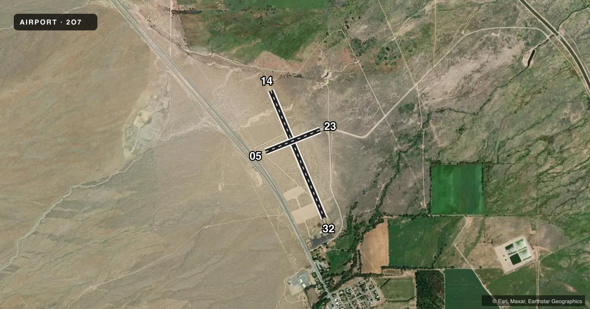
Runways & pattern
Full pagePattern entry · RWY 14
LEFT TRAFFIC| Runway | Heading (°M) | Length | Surface | Traffic |
|---|---|---|---|---|
| 14/32Favored | 142° / 322° | 3,533 ft | ASPH | 32 R |
| 05/23 | 53° / 233° | 1,498 ft | DIRT | Standard L |
Runway end performance
| End | TORA | TODA | ASDA | LDA | VGSI | Approach lights | Obstruction |
|---|---|---|---|---|---|---|---|
| 14 | — | — | — | — | — | — | 6', fence, 325' from thr, 0' R of cntrln, slope 20 |
| 32 | — | — | — | — | — | — | 43', trees, 900' from thr, 110' R of cntrln, slope 16 |
| 05 | — | — | — | — | — | — | 15', road, 210' from thr, 0' R of cntrln, slope 14 |
| 23 | — | — | — | — | — | — | 6', fence, 150' from thr, 140' R of cntrln, slope 25 |
Declared distances in feet. TORA = takeoff run available, TODA = takeoff distance, ASDA = accelerate-stop, LDA = landing distance.
Airport sketch
Runways drawn to scale from FAA survey coordinates, rendered over satellite imagery. Not for navigation.
Approaches & charts
Services on the field
Fuel grades, oxygen, maintenance, ramp storage and lighting — as declared to the FAA by the airport operator.
Fuel & services
- Fuel
- Not available
- Oxygen (bottled)
- Not available
- Oxygen (bulk)
- Not available
- Airframe repair
- Not available
- Power plant repair
- Not available
Ramp & ground
- Transient storage
- Tie-down
- Landing fee
- No fee published
- Customs
- Not available
- Lighting schedule
- SEE RMK
- Wind indicator
- Lighted
- Segmented circle
- Yes
Fuel & FBOs
Cheapest 100LL and Jet A on the field and nearby. Always confirm with the FBO before taxi.
Airport notes
Surface conditions, obstructions, local procedures, lighting outages and other notes published with each FAA cycle.
General notes
- FOR CD CTC JOSHUA APCH AT 661-277-3843.
- RWY 5/23 UNDULATING UNEVEN DIRT SFC. BRUSH IN SPORADIC LOCATIONS ON RWY.
- RWY 5/23 CLSD FOR PUBLIC USE.
- RWY 5/23 UNSAFE FOR ACFT.
Lighting notes
- ACTVT MIRL RY 14/32 - CTAF.
Runway surface & condition
- 05/23RESTRICTED CAN BE USED ONLY DURING EXTREME CROSSWIND CONDS.
Approach & departure obstructions
- 05& RY 23 MARKED WITH AN R ON EACH END; NO NUMBERS OR CNTRLN MARKINGS; MARKINGS FADED.
Other notes
- ESTABD PRIOR 5/15/59.
- TFC PAT INDICATORS FOR RWY 14/32 ONLY.
- MANAGERDIRECTOR OF PUBLIC WORKS INYO COUNTY.
- OWNERLEASED & MAINTAINED BY INYO COUNTY.
- 05/23SFC UNEVEN, ROUGH, UNDULATING WITH EXTSV BRUSH. UNSAFE FOR ACFT USE.
- 14/32EXTSV LRG CRACKS ON THE NORTH END OF THE RWY.
VFR map & nearby airports
VFR sectional. Tap any ICAO chip to open that airport.
Key facts · 2O7
Answer card- ICAO
- 2O7
- Name
- INDEPENDENCE
- Location
- INDEPENDENCE, CALIFORNIA
- Elevation
- 3,908.2 ft MSL
- Traffic pattern altitude
- 4,708.2 ft MSL (800 AGL)
- Control tower
- Non-towered (use CTAF)
- Total runways
- 2
- Longest runway
- 14/32 · 3,533 ft
- Published ILS approaches
- 0
- Published frequencies
- 1
- Magnetic variation
- 15°
- Current flight rules
- VFR
- Current wind
- 140° at 12 kt
- Favored runway now
- RWY 14
Independence Airport sits in Independence, California. Field elevation is 3,908.2 ft MSL. The airport has two runways. The longest is runway 14/32 at 3,533 ft. Runway 5/23 is 1,498 ft dirt. The published remarks say it is closed for public use and unsafe for aircraft. The field is not towered. CTAF is 122.9. Pattern altitude is 800 ft AGL, which is 4,708.2 ft MSL.
There are no ILS approaches published here. The airport is leased and maintained by Inyo County. The airport manager is the Director of Public Works for Inyo County. Medium intensity runway lighting is available on runway 14/32. It is activated by using the CTAF. Published remarks also note large cracks on the north end of runway 14/32. That is worth a close look before you plan a landing.
For a first-time arrival, the big points are elevation, runway condition and the lack of tower services. Expect high-density-altitude performance to matter here because the field sits above 3,900 ft MSL. If you need clearance delivery, contact Joshua Approach at 661-277-3843. Runway 5/23 has faded markings. It has no numbers or centerline markings. Brush is present in places. Treat it as closed for public use and do not plan on it.