METAR & TAF 1Q1
1Q1 does not publish a METAR.
Showing the nearest reporting station: KPTV (PORTERVILLE MUNI) · 8.0 NM away. Conditions at 1Q1 may differ.
METAR · KPTV
Observed 08:56Z
KPTV 270856Z AUTO 28004KT 10SM CLR 22/13 A2994 RMK AO2 SLP136 T02220133 52003 $
- Wind
- 280° @ 4 kt
- Visibility
- 10 SM
- Temp / Dew
- 22°C / 13°C
- Altimeter
- 29.94 inHg
- Clouds
- CLR
- Density alt
- 1,343 ft
- Ceiling
- Unlimited
- Rules
- VFR
Airport info & contacts
Manager on record, flight service, ARTCC, attendance schedule and pattern altitude — published by the FAA and refreshed every 28 days.
Location
- From city
- 1 NM NE
- VFR sectional
- SAN FRANCISCO
- ARTCC
- ZOA · OAKLAND
- NOTAM facility
- RIU (NOTAM-D)
Airport manager
- Name
- JASON SKIBY
- Phone
- 661-205-4675
- Address
- 2299 HUNTINTON DRIVE # D, SAN MARINO CA 91108
Flight service · Hours
- FSS RIU
- RANCHO MURIETA1-800-WX-BRIEF
- Attendance
- DALGT
Frequencies
Tap any row to copy the frequency to your clipboard.
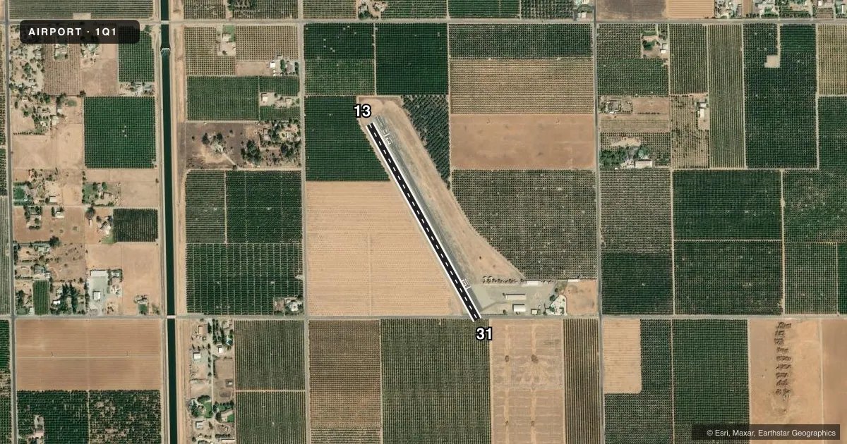
Runways & pattern
Full pagePattern entry · RWY 31
LEFT TRAFFICRunway end performance
| End | TORA | TODA | ASDA | LDA | VGSI | Approach lights | Obstruction |
|---|---|---|---|---|---|---|---|
| 13 | — | — | — | — | — | — | 20', trees, 245' from thr, 130' R of cntrln, slope 1 |
| 31 | — | — | — | — | — | — | 15', trees, 200' from thr, 0' R of cntrln, slope 0 |
Declared distances in feet. TORA = takeoff run available, TODA = takeoff distance, ASDA = accelerate-stop, LDA = landing distance.
Airport sketch
Runways drawn to scale from FAA survey coordinates, rendered over satellite imagery. Not for navigation.
Approaches & charts
Services on the field
Fuel grades, oxygen, maintenance, ramp storage and lighting — as declared to the FAA by the airport operator.
Fuel & services
- Fuel
- Not available
- Oxygen (bottled)
- Not available
- Oxygen (bulk)
- Not available
- Airframe repair
- Not available
- Power plant repair
- Not available
- Other services
- INSTR,TOW
Ramp & ground
- Transient storage
- Tie-down
- Landing fee
- No fee published
- Wind indicator
- Yes
- Segmented circle
- No
Fuel & FBOs
Cheapest 100LL and Jet A on the field and nearby. Always confirm with the FBO before taxi.
Airport notes
Surface conditions, obstructions, local procedures, lighting outages and other notes published with each FAA cycle.
General notes
- NIGHT OPNS PROHIBITED.
- FOR CD CTC OAKLAND ARTCC AT 510-745-3380.
Runway surface & condition
- 13/31GWT 10000 LBS PRVDD BY ARPT MGR.
Approach & departure obstructions
- 13+20' TREES 185'-225' FM THR 125'L-125'R.
- 31+3 FT BUSHES AT THLD; +15 FT ROAD 0-125 FT FM THLD 125 FT L-125 FT R; +20 FT TREES 15-150 FT FM THLD 125 FT L-125 FT R.
- 13RY 13 /31 BSC MARKINGS & EDGES MARKED WITH 4 INCH WHITE LINES.
- 1321:1 OVER TREES TO DSPL THR
- 31RWY 31 APPROACH SLOPE 31:1 OVER TREES TO DSPL THR. APPROACH SLOPE 16:1 TO ROAD 253 FM DSPL THR ON CENTERLINE.
VFR map & nearby airports
VFR sectional. Tap any ICAO chip to open that airport.
Key facts · 1Q1
Answer card- ICAO
- 1Q1
- Name
- KINGTECH FLD
- Location
- STRATHMORE, CALIFORNIA
- Elevation
- 426 ft MSL
- Traffic pattern altitude
- 1,426 ft MSL (1,000 AGL)
- Control tower
- Non-towered (use CTAF)
- Total runways
- 1
- Longest runway
- 13/31 · 2,000 ft
- Published ILS approaches
- 0
- Published frequencies
- 2
- Magnetic variation
- 15°
- Current flight rules
- VFR
- Current wind
- 280° at 4 kt
- Favored runway now
- RWY 31
Eckert Fld (1Q1) is in Strathmore, California. The field elevation is 426 ft MSL. It has one runway. Runway 13/31 is 2,000 ft long and asphalt. There is no control tower. CTAF and UNICOM are both 122.8. No ILS approaches are published.
Pattern altitude is not published. Use 1,000 ft AGL for light piston traffic unless the current Chart Supplement says otherwise. That puts the standard pattern at 1,426 ft MSL based on the field elevation. Night operations are prohibited, so plan to arrive and depart in daylight only. The airport also has a gross weight limit of 10,000 pounds per the airport manager.
The published remarks matter here. Runway 31 has tree and road obstructions on approach, with a displaced threshold. Runway 13 also has tree obstructions on approach. The ramp is reported to be in poor condition with potholes and a section of unraveling pavement. Runway markings are basic, with 4 inch white edge lines. No on-field FBOs are listed, so verify services with the airport operator or call the field on CTAF before you go. For clearance delivery, Oakland ARTCC is listed at 510-745-3380.