METAR & TAF D86
D86 does not publish a METAR.
Showing the nearest reporting station: KVIS (VISALIA MUNI) · 8.5 NM away. Conditions at D86 may differ.
METAR · KVIS
Observed 09:56Z
KVIS 270956Z AUTO 31007KT 10SM CLR 22/13 A2993 RMK AO2 SLP131 T02170128 $
- Wind
- 310° @ 7 kt
- Visibility
- 10 SM
- Temp / Dew
- 22°C / 13°C
- Altimeter
- 29.93 inHg
- Clouds
- CLR
- Density alt
- 1,216 ft
- Ceiling
- Unlimited
- Rules
- VFR
Airport info & contacts
Manager on record, flight service, ARTCC, attendance schedule and pattern altitude — published by the FAA and refreshed every 28 days.
Location
- From city
- 8 NM N
- VFR sectional
- SAN FRANCISCO
- Pattern altitude
- 800 ft AGL · 1,113 ft MSL
- ARTCC
- ZOA · OAKLAND
- NOTAM facility
- RIU (NOTAM-D)
Airport manager
- Name
- REED SCHENICKE
- Phone
- 559-624-7000
- Address
- 5961 SOUTH MOONEY, VISALIA CA 93277-4584
Flight service · Hours
- FSS RIU
- RANCHO MURIETA1-800-WX-BRIEF
- Attendance
- Unattended
Frequencies
Tap any row to copy the frequency to your clipboard.
Runways & pattern
Full pagePattern entry · RWY 31
LEFT TRAFFICRunway end performance
| End | TORA | TODA | ASDA | LDA | VGSI | Approach lights | Obstruction |
|---|---|---|---|---|---|---|---|
| 13 | — | — | — | — | — | — | 5', fence, 200' from thr, 85' R of cntrln, slope 0 |
Declared distances in feet. TORA = takeoff run available, TODA = takeoff distance, ASDA = accelerate-stop, LDA = landing distance.
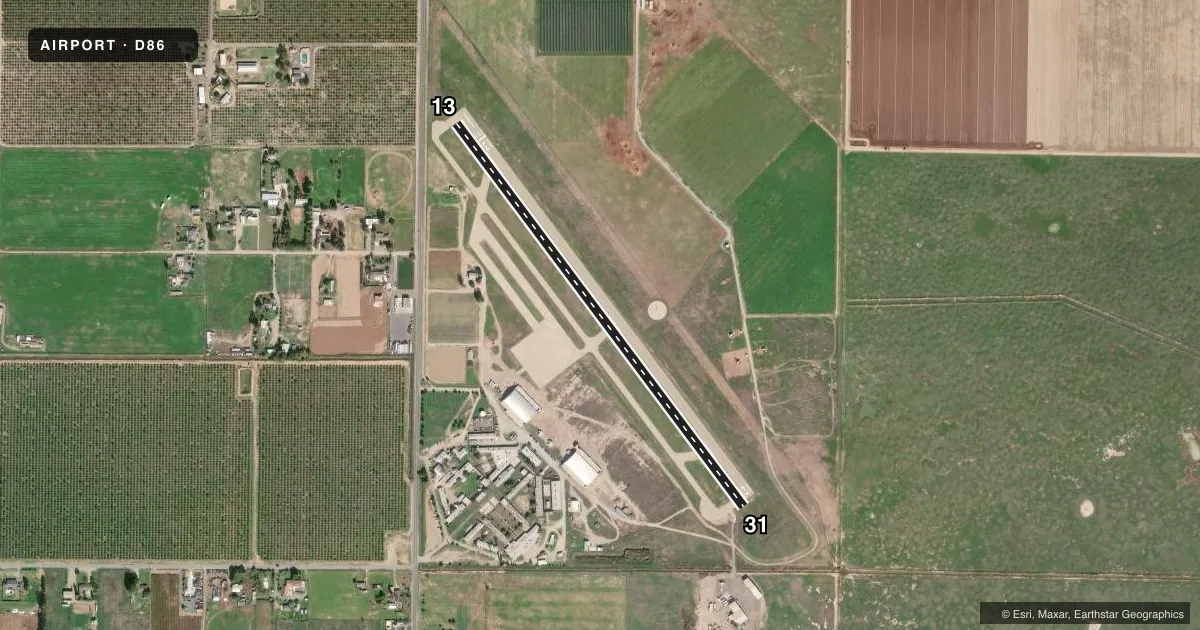
Airport sketch
Runways drawn to scale from FAA survey coordinates, rendered over satellite imagery. Not for navigation.
Approaches & charts
Services on the field
Fuel grades, oxygen, maintenance, ramp storage and lighting — as declared to the FAA by the airport operator.
Fuel & services
- Fuel
- Not available
- Oxygen (bottled)
- Not available
- Oxygen (bulk)
- Not available
- Airframe repair
- Not available
- Power plant repair
- Not available
- Other services
- AGRI
Ramp & ground
- Transient storage
- Tie-down
- Landing fee
- No fee published
- Customs
- Not available
- Lighting schedule
- SS-SR
- Wind indicator
- Lighted
- Segmented circle
- No
Fuel & FBOs
Cheapest 100LL and Jet A on the field and nearby. Always confirm with the FBO before taxi.
Airport notes
Surface conditions, obstructions, local procedures, lighting outages and other notes published with each FAA cycle.
General notes
- FOR CD CTC FRESNO APCH AT 559-454-9805.
Approach & departure obstructions
- 13+5 FT FENCE 0-200 FT FM RY END 125 FT RIGHT TO 85 FT RIGHT.
- 13APCH RATIO TO DSPLCD THLD 50:1 FM +5 FT FENCE 100 FT RIGHT 255 FT FM DSPLCD THLD.
Other notes
- ESTABLISHED PRIOR TO 1959.
- FIRE FIGHTING ACFT BASED IN WINTER.
- MANAGERRMD DIRECTOR
VFR map & nearby airports
VFR sectional. Tap any ICAO chip to open that airport.
Key facts · D86
Answer card- ICAO
- D86
- Name
- SEQUOIA FLD
- Location
- VISALIA, CALIFORNIA
- Elevation
- 313 ft MSL
- Traffic pattern altitude
- 1,113 ft MSL (800 AGL)
- Control tower
- Non-towered (use CTAF)
- Total runways
- 1
- Longest runway
- 13/31 · 3,012 ft
- Published ILS approaches
- 0
- Published frequencies
- 1
- Magnetic variation
- 15°
- Current flight rules
- VFR
- Current wind
- 310° at 7 kt
- Favored runway now
- RWY 31
Sequoia Fld (D86) is in Visalia, California. The field elevation is 313 ft MSL. It has one runway. Runway 13/31 is 3,012 ft long with an asphalt surface. The airport is non-towered, so traffic calls go on CTAF 122.9. Pattern altitude is 800 ft AGL, which is 1,113 ft MSL.
There are no published ILS approaches here. Plan for VFR or other non-ILS procedures as published. The runway is short enough that performance planning matters, especially on warm Central Valley days. Published remarks note fence obstructions near the displaced threshold on runway 13. That makes a stabilized approach and a close read of the current Chart Supplement important before arrival. Fire fighting aircraft are based here in winter, so expect the airport to see seasonal operational activity.
No on-field FBOs are listed in the facts. FBO options vary. Contact the airport operator directly before arrival, or call the field on CTAF/UNICOM for current FBO availability. For clearance delivery, contact Fresno Approach at 559-454-9805. If you are new to the field, review the runway 13 threshold notes and the current airport remarks before you go. The airport sits in the Visalia area with 15° magnetic variation, so use current charts and published data for your planning.