METAR & TAF KVIS
Current METAR
Observed 16:56Z
KVIS 261656Z AUTO 13007KT 10SM CLR 26/13 A3000 RMK AO2 SLP157 T02610128 $
- Wind
- 130° @ 7 kt
- Visibility
- 10 SM
- Temp / Dew
- 26°C / 13°C
- Altimeter
- 30.00 inHg
- Clouds
- CLR
- Density alt
- 1,584 ft
- Ceiling
- Unlimited
- Rules
- VFR
Airport info & contacts
Manager on record, flight service, ARTCC, attendance schedule and pattern altitude — published by the FAA and refreshed every 28 days.
Location
- From city
- 4 NM W
- VFR sectional
- SAN FRANCISCO
- ARTCC
- ZOA · OAKLAND
- NOTAM facility
- VIS (NOTAM-D)
Airport manager
- Name
- JODY MILLER
- Phone
- (559) 713-4282
- Address
- 9501 ARPT DRIVE, VISALIA CA 93277
Flight service · Hours
- FSS RIU
- RANCHO MURIETA1-800-WX-BRIEF
- Attendance
- MON-FRI · 0800-1800
- SAT-SUN · 0900-1600
Frequencies
Tap any row to copy the frequency to your clipboard.
Runways & pattern
Full pagePattern entry · RWY 12
LEFT TRAFFICRunway end performance
| End | TORA | TODA | ASDA | LDA | VGSI | Approach lights | Obstruction |
|---|---|---|---|---|---|---|---|
| 12 | 6,560' | 7,560' | 6,560' | 5,635' | PAPI 4-box left(3°) | — | 4', fence, 200' from thr, 250' R of cntrln, slope 0 |
| 30 | 5,635' | 6,635' | 5,635' | 5,635' | PAPI 4-box left(3°) | MALSR | 61', tree, 3175' from thr, 725' R of cntrln, slope 48 |
Declared distances in feet. TORA = takeoff run available, TODA = takeoff distance, ASDA = accelerate-stop, LDA = landing distance.
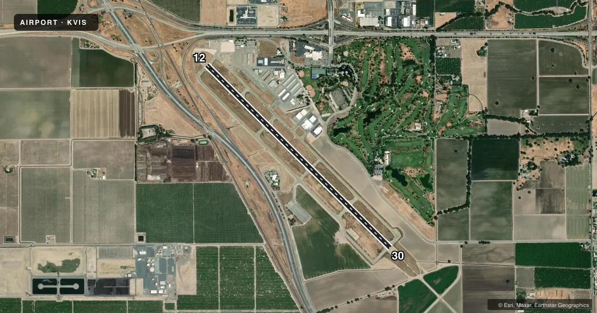
Airport sketch
Runways drawn to scale from FAA survey coordinates, rendered over satellite imagery. Not for navigation.
Approaches & charts
ILS · 1
Services on the field
Fuel grades, oxygen, maintenance, ramp storage and lighting — as declared to the FAA by the airport operator.
Fuel & services
- Fuel
- 100LLA
- Oxygen (bottled)
- Not available
- Oxygen (bulk)
- Not available
- Airframe repair
- Major
- Power plant repair
- Major
- Other services
- AVNCS,CHTR,INSTR,RNTL
Ramp & ground
- Transient storage
- Tie-down
- Landing fee
- No fee published
- Customs
- Not available
- Lighting schedule
- SEE RMK
- Beacon schedule
- SS-SR
- Beacon
- White / Green (civil land)(WG)
- Wind indicator
- Lighted
- Segmented circle
- Yes
Fuel & FBOs
Cheapest 100LL and Jet A on the field and nearby. Always confirm with the FBO before taxi.
Airport notes
Surface conditions, obstructions, local procedures, lighting outages and other notes published with each FAA cycle.
General notes
- RY 30 DESIGNATED CALM WIND RY.
Lighting notes
- ACTVT MALSR RWY 30; REIL RWY 12; PAPI RWY 12 & 30; HIRL RWY 12/30 - CTAF.
Fuel notes
- 100LLSELF-SERVICE FUEL 100LL AVBL 24 HRS.
- ASELF-SERVICE FUEL JET A AVBL 24HRS.
Approach & departure obstructions
- H1HELIPAD ON PARALLEL TWY; THEN HOVERTAXI TO ADJACENT CONCRETE PARKING PAD; 20000 LBS MAX WGT.
- 12APCH RATIO 20:1 TO DSPLCD THLD.
Other notes
- RON TIEDOWN FEE.
- NO DOWNWIND TURNS WHEN DEPARTING RWY 12 UNTIL RCHG TFC PAT ALT.
- MANAGEREMAIL: JODY.MILLER@VISALIA.CITY
VFR map & nearby airports
VFR sectional. Tap any ICAO chip to open that airport.
Key facts · KVIS
Answer card- ICAO
- KVIS
- Name
- VISALIA MUNI
- Location
- VISALIA, CALIFORNIA
- Elevation
- 292.5 ft MSL
- Traffic pattern altitude
- 1,292.5 ft MSL (1,000 AGL)
- Control tower
- Non-towered (use CTAF)
- Total runways
- 1
- Longest runway
- 12/30 · 6,562 ft
- Published ILS approaches
- 1
- Published frequencies
- 4
- Magnetic variation
- 14°
- Current flight rules
- VFR
- Current wind
- 130° at 7 kt
- Favored runway now
- RWY 12
Visalia Muni is in Visalia, California. The field elevation is 292.5 ft MSL. It has one runway, 12/30, which is 6,562 ft long with asphalt pavement. There is no control tower, so use CTAF 123.05 for local traffic and UNICOM on the same frequency if needed. The published pattern altitude is not listed, so plan on the standard 1,000 ft AGL for light piston operations unless the current Chart Supplement says otherwise.
Runway 30 has an ILS approach. The published lighting setup is useful for night work. MALSR is on runway 30. REIL is available for runway 12. PAPI is available for both runway ends. High intensity runway lighting is available on 12/30. Runway 30 is the calm wind runway. There is also a published note that no downwind turns are permitted when departing runway 12 until reaching traffic pattern altitude. The runway 12 approach slope also has a 20 to 1 obstruction note to the displaced threshold, so brief that side carefully before arrival.
Visalia Municipal Airport is the on-field FBO. It carries 100LL and Jet A. Self-serve 100LL and self-serve Jet A are both available 24 hours. The airport also notes a helipad on the parallel taxiway with hover taxi to the adjacent concrete pad. Maximum weight there is 20,000 pounds. For any current operating detail that is not published here, check the current FAA Chart Supplement or call the airport operator directly.