METAR & TAF KPTV
Current METAR
Observed 01:56Z
KPTV 270156Z AUTO 28008KT 10SM CLR 37/11 A2989 RMK AO2 SLP118 T03670111 $
- Wind
- 280° @ 8 kt
- Visibility
- 10 SM
- Temp / Dew
- 37°C / 11°C
- Altimeter
- 29.89 inHg
- Clouds
- CLR
- Density alt
- 3,227 ft
- Ceiling
- Unlimited
- Rules
- VFR
Airport info & contacts
Manager on record, flight service, ARTCC, attendance schedule and pattern altitude — published by the FAA and refreshed every 28 days.
Location
- From city
- 3 NM SW
- VFR sectional
- SAN FRANCISCO
- ARTCC
- ZLA · LOS ANGELES
- NOTAM facility
- PTV (NOTAM-D)
Airport manager
- Name
- ALBERTO BARRAGAN
- Phone
- 559-483-0904
- Address
- 1893 SOUTH NEWCOMB ROAD, PORTERVILLE CA 93257-7466
Flight service · Hours
- FSS RIU
- RANCHO MURIETA1-800-WX-BRIEF
- Attendance
- MAY-OCT · 0700-1900
- NOV-APR · 0800-1700
Frequencies
Tap any row to copy the frequency to your clipboard.
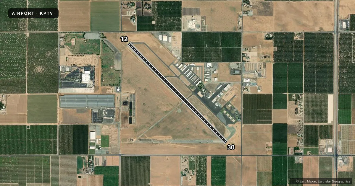
Runways & pattern
Full pagePattern entry · RWY 30
LEFT TRAFFICRunway end performance
| End | TORA | TODA | ASDA | LDA | VGSI | Approach lights | Obstruction |
|---|---|---|---|---|---|---|---|
| 12 | — | — | — | — | VASI 4-box right(3°) | — | 15', road, 480' from thr, 292' R of cntrln, slope 18 |
| 30 | — | — | — | — | VASI 4-box right(3°) | — | 15', road, 520' from thr, 298' R of cntrln, slope 21 |
Declared distances in feet. TORA = takeoff run available, TODA = takeoff distance, ASDA = accelerate-stop, LDA = landing distance.
Airport sketch
Runways drawn to scale from FAA survey coordinates, rendered over satellite imagery. Not for navigation.
Approaches & charts
Services on the field
Fuel grades, oxygen, maintenance, ramp storage and lighting — as declared to the FAA by the airport operator.
Fuel & services
- Fuel
- 100LLA
- Oxygen (bottled)
- Not available
- Airframe repair
- Major
- Power plant repair
- Major
- Other services
- CHTR,INSTR,RNTL,SALES,SURV
Ramp & ground
- Transient storage
- Tie-down
- Landing fee
- No fee published
- Customs
- Not available
- Lighting schedule
- SEE RMK
- Beacon schedule
- SS-SR
- Beacon
- White / Green (civil land)(WG)
- Wind indicator
- Lighted
- Segmented circle
- Yes
Fuel & FBOs
Cheapest 100LL and Jet A on the field and nearby. Always confirm with the FBO before taxi.
Airport notes
Surface conditions, obstructions, local procedures, lighting outages and other notes published with each FAA cycle.
Lighting notes
- HIRL RY 12/30 PRESET LOW INTST DUSK-2300; AFTER 2300 ACTVT - CTAF. ACTVT VASI RY 12 - CTAF, VASI RY 30 OPER CONTINUOUSLY.
Fuel notes
- 100LLSELF SERVICE FUEL AVBL 24 HRS WITH CREDIT CARD.
Other notes
- 1ARPT ATTENDANT 559-782-7540.
- MANAGEREMERGENCY CONTACT PORTERVILLE PD 559-782-7400
VFR map & nearby airports
VFR sectional. Tap any ICAO chip to open that airport.
Key facts · KPTV
Answer card- ICAO
- KPTV
- Name
- PORTERVILLE MUNI
- Location
- PORTERVILLE, CALIFORNIA
- Elevation
- 443.2 ft MSL
- Traffic pattern altitude
- 1,443.2 ft MSL (1,000 AGL)
- Control tower
- Non-towered (use CTAF)
- Total runways
- 1
- Longest runway
- 12/30 · 5,960 ft
- Published ILS approaches
- 0
- Published frequencies
- 3
- Magnetic variation
- 15°
- Current flight rules
- VFR
- Current wind
- 280° at 8 kt
- Favored runway now
- RWY 30
Porterville Muni is in Porterville, California. The field elevation is 443.2 ft MSL. It has one runway, 12/30, which is 5,960 ft long. There is no control tower. Approach service is through Bakersfield on 119.075. No ILS approaches are published.
For pattern work, use the published pattern altitude if you have it from the current Chart Supplement. The facts here do not list a published pattern altitude. For a light piston, plan on 1,000 ft AGL unless current published data says otherwise. The airport sits in the Central Valley, so expect straightforward terrain. Still, verify the latest charted airspace and local procedures before you go.
The on-field FBO is Porterville Municipal Airport. It carries 100LL, Jet A and Jet A Prist. Self-service 100LL is available 24 hours with a credit card. The runway lights for 12/30 are preset to low intensity from dusk to 2300. After 2300, activate them on the CTAF. The VASI for runway 12 is also activated on CTAF. The VASI for runway 30 operates continuously. If you need current field details, call the airport attendant at 559-782-7540.