METAR & TAF KDLO
Current METAR
Observed 10:55Z
KDLO 271055Z AUTO 00000KT 10SM 19/12 A2994 RMK AO2 T01880120
- Wind
- 000° @ 0 kt
- Visibility
- 10 SM
- Temp / Dew
- 19°C / 12°C
- Altimeter
- 29.94 inHg
- Clouds
- Clear
- Density alt
- 847 ft
- Ceiling
- Unlimited
- Rules
- VFR
Airport info & contacts
Manager on record, flight service, ARTCC, attendance schedule and pattern altitude — published by the FAA and refreshed every 28 days.
Location
- From city
- 2 NM SE
- VFR sectional
- LOS ANGELES
- Pattern altitude
- 800 ft AGL · 1,116 ft MSL
- ARTCC
- ZLA · LOS ANGELES
- NOTAM facility
- RIU (NOTAM-D)
Airport manager
- Name
- PEDRO NUNEZ
- Phone
- 661-720-2219
- Address
- CITY OF DELANO, 1015 11TH AVENUE, DELANO CA 93215-2262
Flight service · Hours
- FSS RIU
- RANCHO MURIETA1-800-WX-BRIEF
- Attendance
- 0800-1700
Frequencies
Tap any row to copy the frequency to your clipboard.
Runways & pattern
Full pagePattern entry · RWY 15
RIGHT TRAFFICRunway end performance
| End | TORA | TODA | ASDA | LDA | VGSI | Approach lights | Obstruction |
|---|---|---|---|---|---|---|---|
| 15 | — | — | — | — | PAPI 2-box left(3.5°) | — | 30', trees, 240' from thr, 108' R of cntrln, slope 1 |
| 33 | — | — | — | — | PAPI 2-box left(3°) | — | — |
Declared distances in feet. TORA = takeoff run available, TODA = takeoff distance, ASDA = accelerate-stop, LDA = landing distance.
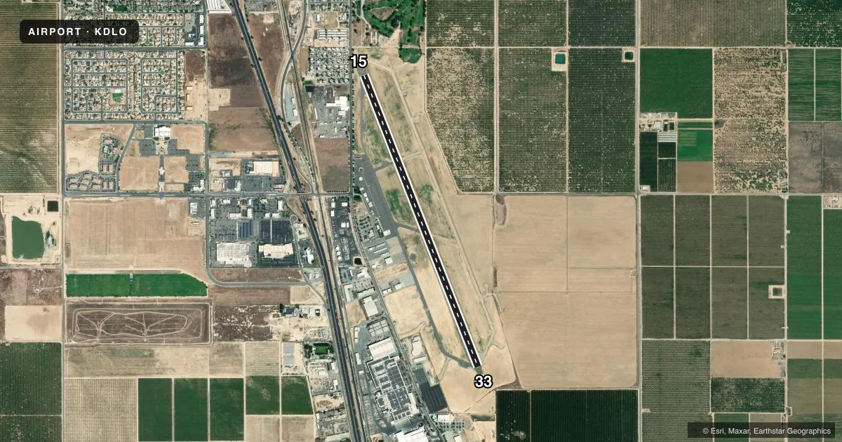
Airport sketch
Runways drawn to scale from FAA survey coordinates, rendered over satellite imagery. Not for navigation.
Approaches & charts
Services on the field
Fuel grades, oxygen, maintenance, ramp storage and lighting — as declared to the FAA by the airport operator.
Fuel & services
- Fuel
- 100LL
- Oxygen (bottled)
- Not available
- Oxygen (bulk)
- Not available
- Airframe repair
- Minor
- Power plant repair
- Major
- Other services
- INSTR
Ramp & ground
- Transient storage
- Tie-down
- Landing fee
- No fee published
- Customs
- Not available
- Lighting schedule
- SEE RMK
- Beacon schedule
- SS-SR
- Beacon
- White / Green (civil land)(WG)
- Wind indicator
- Lighted
- Segmented circle
- Yes
Fuel & FBOs
Cheapest 100LL and Jet A on the field and nearby. Always confirm with the FBO before taxi.
Airport notes
Surface conditions, obstructions, local procedures, lighting outages and other notes published with each FAA cycle.
General notes
- SEASONAL CROP DUSTER OPNS ON ARPT E OF RWY 15/33. AREA E OF RWY IS RSTRD AGRICULTURAL USE ONLY.
- AFTER HRS EMERGENCY CTC POLICE DEPT (661) 721-3377.
- (E81) RWY 15/33 RWY EXIT LGTS.
- FOR CD CTC LOS ANGELES ARTCC AT 661-575-2079.
Lighting notes
- MIRL RWY 15/33 PRESET LOW INTST SS-SR; TO INCR INTST ACTVT - CTAF.
Approach & departure obstructions
- 15APCH RATIO 50:1 TO DSPLCD THR.
Other notes
- MANAGEREMAIL: PNUNEZ@CITYOFDELANO.ORG
VFR map & nearby airports
VFR sectional. Tap any ICAO chip to open that airport.
Key facts · KDLO
Answer card- ICAO
- KDLO
- Name
- DELANO MUNI
- Location
- DELANO, CALIFORNIA
- Elevation
- 316.3 ft MSL
- Traffic pattern altitude
- 1,116.3 ft MSL (800 AGL)
- Control tower
- Non-towered (use CTAF)
- Total runways
- 1
- Longest runway
- 15/33 · 5,659 ft
- Published ILS approaches
- 0
- Published frequencies
- 3
- Magnetic variation
- 12°
- Current flight rules
- VFR
- Current wind
- 000° at 0 kt
- Favored runway now
- –
Delano Muni sits in Delano, California at 316.3 ft MSL. It has one runway, 15/33, which is 5,659 ft long. The field is non-towered. CTAF and UNICOM are both 122.8. Bakersfield Approach and Departure use 118.9 for the area. No ILS approaches are published here.
Pattern altitude is 800 ft AGL. That works out to 1,116.3 ft MSL. Runway 15/33 has runway exit lights. The medium intensity runway lights are preset to low intensity from sunset to sunrise. If you need more light, activate the CTAF.
Loyd's Aviation is on the field. It carries 100LL and Jet A. Seasonal crop duster activity happens east of runway 15/33. The area east of the runway is restricted to agricultural use only, so pay close attention to traffic and surface use on that side. There is also a published 50:1 approach note to the displaced threshold on runway 15.
For a first-time arrival, plan for a non-towered pattern and keep the agricultural activity in mind. If you need clearance delivery, contact Los Angeles ARTCC at 661-575-2079. For airport management questions, the published manager email is PNUNEZ@CITYOFDELANO.ORG.