METAR & TAF L62
L62 does not publish a METAR.
Showing the nearest reporting station: KBFL (MEADOWS FLD) · 21.2 NM away. Conditions at L62 may differ.
METAR · KBFL
Observed 05:54Z
KBFL 270554Z AUTO 33004KT 10SM CLR 26/08 A2992 RMK AO2 SLP124 T02610083 10372 20261 53013 $
- Wind
- 330° @ 4 kt
- Visibility
- 10 SM
- Temp / Dew
- 26°C / 8°C
- Altimeter
- 29.92 inHg
- Clouds
- CLR
- Density alt
- 1,724 ft
- Ceiling
- Unlimited
- Rules
- VFR
Airport info & contacts
Manager on record, flight service, ARTCC, attendance schedule and pattern altitude — published by the FAA and refreshed every 28 days.
Location
- From city
- 3 NM S
- VFR sectional
- LOS ANGELES
- Pattern altitude
- 800 ft AGL · 1,126 ft MSL
- ARTCC
- ZLA · LOS ANGELES
- NOTAM facility
- RIU (NOTAM-D)
Airport manager
- Name
- BILL LAMANQUE
- Phone
- (661) 391-1824
- Address
- 3701 WINGS WAY, SUITE 300, BAKERSFIELD CA 93308-7026
Flight service · Hours
- FSS RIU
- RANCHO MURIETA1-800-WX-BRIEF
- Attendance
- Unattended
Frequencies
Tap any row to copy the frequency to your clipboard.
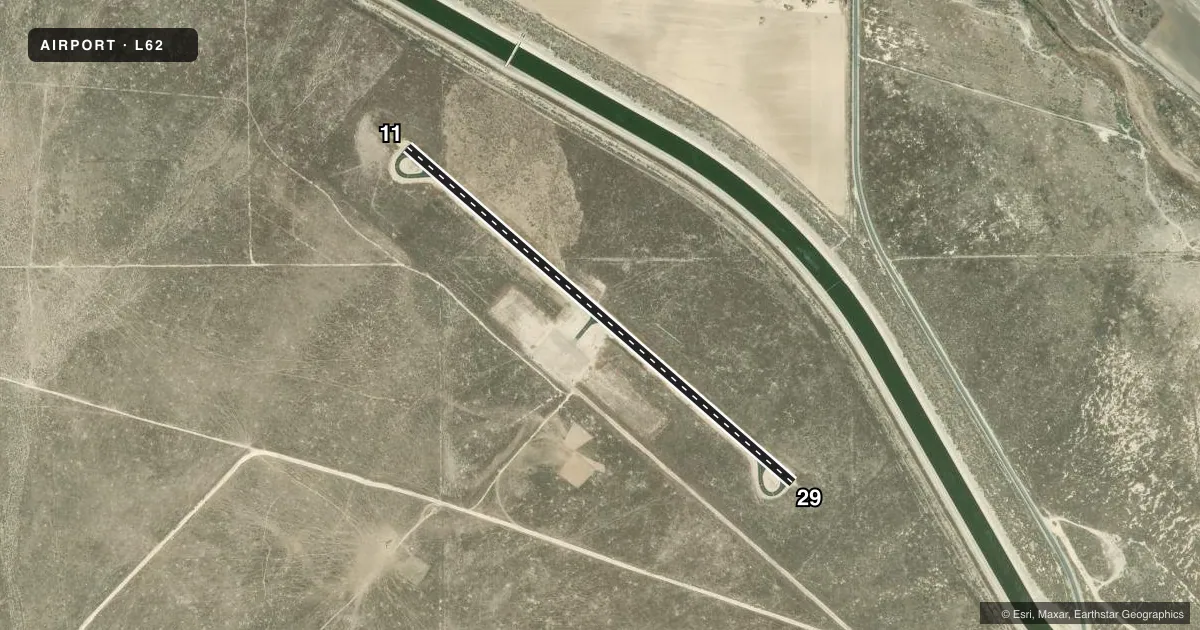
Runways & pattern
Full pagePattern entry · RWY 29
LEFT TRAFFICAirport sketch
Runways drawn to scale from FAA survey coordinates, rendered over satellite imagery. Not for navigation.
Approaches & charts
Services on the field
Fuel grades, oxygen, maintenance, ramp storage and lighting — as declared to the FAA by the airport operator.
Fuel & services
- Fuel
- Not available
- Oxygen (bottled)
- Not available
- Oxygen (bulk)
- Not available
- Airframe repair
- Not available
- Power plant repair
- Not available
Ramp & ground
- Transient storage
- Tie-down
- Landing fee
- No fee published
- Customs
- Not available
- Wind indicator
- Yes
- Segmented circle
- Yes
Fuel & FBOs
Cheapest 100LL and Jet A on the field and nearby. Always confirm with the FBO before taxi.
Airport notes
Surface conditions, obstructions, local procedures, lighting outages and other notes published with each FAA cycle.
General notes
- ARPT CLSD TO NIGHT OPNS.
- ELK HILLS-BUTTONWILLOW ELEV 326 PAINTED ON CENTER OF RWY.
- CROP DUSTING OPNS PROHIBITED EXCP BY PPR AMGR 661-391-1800.
- RADIO CTLD MODEL ACFT BELOW 800 FT AGL INVOF ARPT.
- FOR CD CTC LOS ANGELES ARTCC AT 661-575-2079.
Other notes
- MANAGERDIRECTOR, KERN COUNTY AIRPORTS
- MANAGER24 HR EMERG PHONE 661-747-4055.
- 11/29ALLIGATOR CRACKING; PAVEMENT STBL.
VFR map & nearby airports
VFR sectional. Tap any ICAO chip to open that airport.
Key facts · L62
Answer card- ICAO
- L62
- Name
- ELK HILLS-BUTTONWILLOW
- Location
- BUTTONWILLOW, CALIFORNIA
- Elevation
- 326 ft MSL
- Traffic pattern altitude
- 1,126 ft MSL (800 AGL)
- Control tower
- Non-towered (use CTAF)
- Total runways
- 1
- Longest runway
- 11/29 · 3,260 ft
- Published ILS approaches
- 0
- Published frequencies
- 1
- Magnetic variation
- 15°
- Current flight rules
- VFR
- Current wind
- 330° at 4 kt
- Favored runway now
- RWY 29
Elk Hills-Buttonwillow (L62) sits in Buttonwillow, California. Field elevation is 326 ft MSL. The airport has one runway. Runway 11/29 is 3,260 ft long and asphalt. The published pattern altitude is 800 ft AGL, which is 1,126 ft MSL. There is no control tower. CTAF is 122.9.
No ILS approaches are published here. Plan for non-towered operations and use the current FAA Chart Supplement for any approach or airport detail you need before departure. The published remarks also say the airport is closed to night operations. Radio controlled model aircraft operate below 800 ft AGL in the vicinity of the field. Crop dusting is not allowed unless the manager gives prior permission.
There are no on-field FBOs listed in the facts. FBO options vary. Contact the airport operator directly before arrival, or call the field on CTAF/UNICOM for current FBO availability. The runway remarks note alligator cracking on 11/29, but the pavement is stable. The runway also has the field elevation painted on the centerline, which is a useful visual cue on rollout and taxi. For clearance delivery, contact Los Angeles ARTCC at 661-575-2079.