METAR & TAF L88
L88 does not publish a METAR.
Showing the nearest reporting station: KIZA (SANTA YNEZ/KUNKLE FLD) · 27.7 NM away. Conditions at L88 may differ.
METAR · KIZA
Observed 06:15Z
KIZA 270615Z AUTO 00000KT 10SM SCT014 14/13 A2999 RMK AO2
- Wind
- 000° @ 0 kt
- Visibility
- 10 SM
- Temp / Dew
- 14°C / 13°C
- Altimeter
- 29.99 inHg
- Clouds
- SCT
- Density alt
- 2,526 ft
- Ceiling
- Unlimited
- Rules
- VFR
Airport info & contacts
Manager on record, flight service, ARTCC, attendance schedule and pattern altitude — published by the FAA and refreshed every 28 days.
Location
- From city
- 0 NM S
- VFR sectional
- LOS ANGELES
- ARTCC
- ZLA · LOS ANGELES
- NOTAM facility
- RIU (NOTAM-D)
Airport manager
- Name
- EMILY JOHNSON
- Phone
- 805-770-0926
- Address
- PO BOX 271, NEW CUYAMA CA 93254
Flight service · Hours
- FSS RIU
- RANCHO MURIETA1-800-WX-BRIEF
- Attendance
- Unattended
Frequencies
Tap any row to copy the frequency to your clipboard.
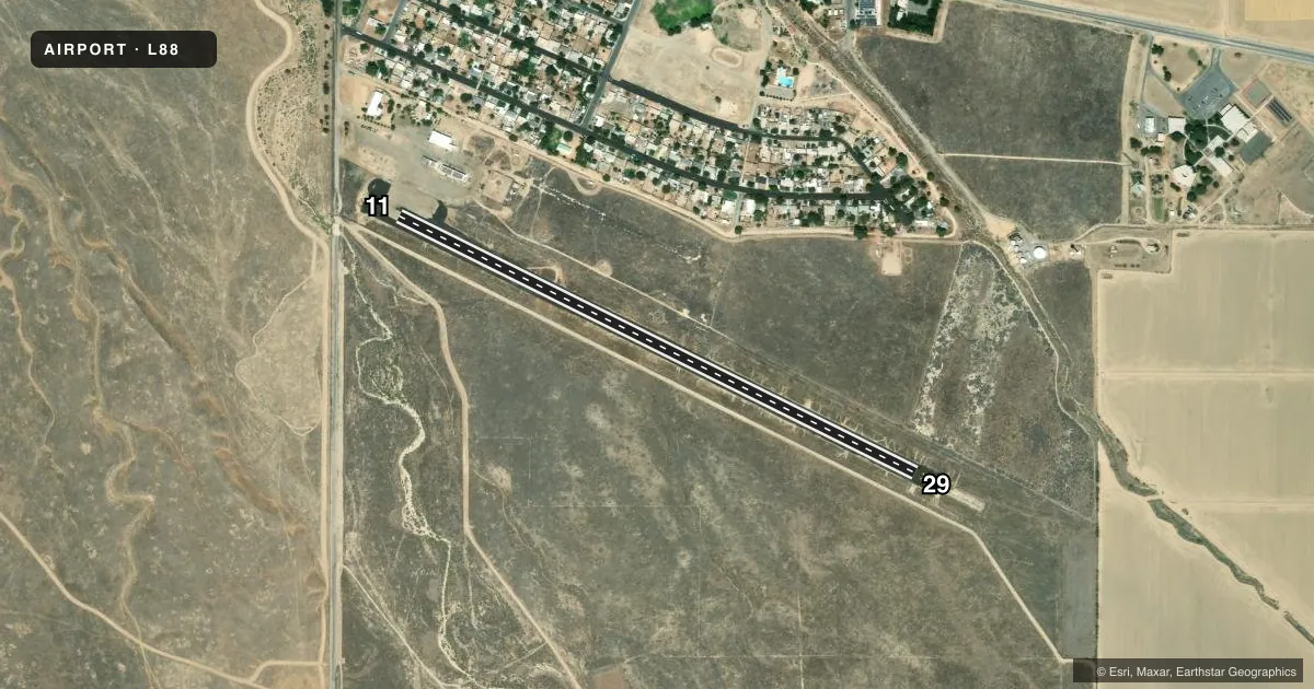
Runways & pattern
Full pagePattern entry · RWY 11
RIGHT TRAFFICAirport sketch
Runways drawn to scale from FAA survey coordinates, rendered over satellite imagery. Not for navigation.
Approaches & charts
Services on the field
Fuel grades, oxygen, maintenance, ramp storage and lighting — as declared to the FAA by the airport operator.
Fuel & services
- Fuel
- Not available
- Oxygen (bottled)
- Not available
- Oxygen (bulk)
- Not available
- Airframe repair
- Not available
- Power plant repair
- Not available
Ramp & ground
- Transient storage
- Tie-down
- Landing fee
- No fee published
- Wind indicator
- Yes
- Segmented circle
- Yes
Fuel & FBOs
Cheapest 100LL and Jet A on the field and nearby. Always confirm with the FBO before taxi.
Airport notes
Surface conditions, obstructions, local procedures, lighting outages and other notes published with each FAA cycle.
General notes
- ACFT PRKG 125 FT N OF RWY CNTRLN AT RWY 11 APCH END.
- RWY 11 +25 FT PWR POLES & PLINES RUN PARTIALLY UNDERGROUND 270 FT BYD RWY END, 164 FT R OF CNTRLN.
- FOR CD CTC LOS ANGELES ARTCC AT 661-575-2079.
VFR map & nearby airports
VFR sectional. Tap any ICAO chip to open that airport.
Key facts · L88
Answer card- ICAO
- L88
- Name
- NEW CUYAMA
- Location
- NEW CUYAMA, CALIFORNIA
- Elevation
- 2,204 ft MSL
- Traffic pattern altitude
- 3,204 ft MSL (1,000 AGL)
- Control tower
- Non-towered (use CTAF)
- Total runways
- 1
- Longest runway
- 11/29 · 3,380 ft
- Published ILS approaches
- 0
- Published frequencies
- 1
- Magnetic variation
- 14°
- Current flight rules
- VFR
- Current wind
- 000° at 0 kt
- Favored runway now
- –
New Cuyama Airport (L88) sits in New Cuyama, California. Field elevation is 2,204 ft MSL. The airport has one runway. Runway 11/29 is 3,380 ft long with an asphalt surface. There is no control tower. CTAF is 122.9. No ILS approaches are published here.
Pattern altitude is not published in the facts. Use standard 1,000 ft AGL for light piston operations unless the current Chart Supplement says otherwise. That puts the pattern at 3,204 ft MSL based on the listed field elevation. Check the current Chart Supplement before flight for any changes.
This is a non-towered field, so expect self-announce traffic and keep a sharp scan. The published remarks matter here. Runway 11 has 25 ft power poles and power lines beyond the departure end. They are 270 ft past the runway end and 164 ft right of centerline. Parking is 125 ft north of the runway centerline at the runway 11 approach end. For clearance delivery, contact Los Angeles ARTCC at 661-575-2079. There are no on-field FBOs listed in the facts, so verify fuel and services with the airport operator or call the field directly before arrival.