METAR & TAF L17
L17 does not publish a METAR.
Showing the nearest reporting station: KBFL (MEADOWS FLD) · 25.6 NM away. Conditions at L17 may differ.
METAR · KBFL
Observed 10:54Z
KBFL 271054Z AUTO 00000KT 10SM CLR 23/11 A2995 RMK AO2 SLP133 T02280111 $
- Wind
- 000° @ 0 kt
- Visibility
- 10 SM
- Temp / Dew
- 23°C / 11°C
- Altimeter
- 29.95 inHg
- Clouds
- CLR
- Density alt
- 1,987 ft
- Ceiling
- Unlimited
- Rules
- VFR
Airport info & contacts
Manager on record, flight service, ARTCC, attendance schedule and pattern altitude — published by the FAA and refreshed every 28 days.
Location
- From city
- 1 NM E
- VFR sectional
- LOS ANGELES
- Pattern altitude
- 800 ft AGL · 1,658 ft MSL
- ARTCC
- ZLA · LOS ANGELES
- NOTAM facility
- RIU (NOTAM-D)
Airport manager
- Name
- BILL LAMANQUE
- Phone
- (661) 391-1824
- Address
- 3701 WINGS WAY, SUITE 300, BAKERSFIELD CA 93308-7026
Flight service · Hours
- FSS RIU
- RANCHO MURIETA1-800-WX-BRIEF
- Attendance
- SAT-SUN · 1000-1600
- MON-FRI · 0800-1600
Frequencies
Tap any row to copy the frequency to your clipboard.
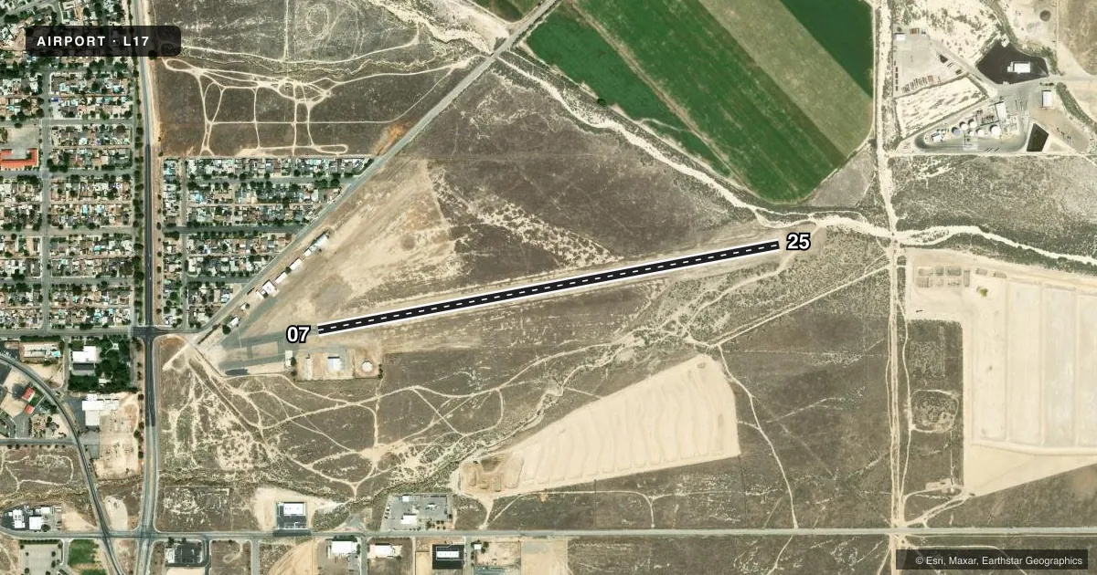
Runways & pattern
Full pagePattern entry · RWY 07
LEFT TRAFFICRunway end performance
| End | TORA | TODA | ASDA | LDA | VGSI | Approach lights | Obstruction |
|---|---|---|---|---|---|---|---|
| 07 | — | — | — | — | — | — | 25', pole, 385' from thr, 100' R of cntrln, slope 7 |
| 25 | — | — | — | — | PAPI 2-box left(3.5°) | — | — |
Declared distances in feet. TORA = takeoff run available, TODA = takeoff distance, ASDA = accelerate-stop, LDA = landing distance.
Airport sketch
Runways drawn to scale from FAA survey coordinates, rendered over satellite imagery. Not for navigation.
Approaches & charts
Services on the field
Fuel grades, oxygen, maintenance, ramp storage and lighting — as declared to the FAA by the airport operator.
Fuel & services
- Fuel
- 100LLA
- Oxygen (bottled)
- Not available
- Oxygen (bulk)
- Not available
- Airframe repair
- Minor
- Power plant repair
- Minor
- Other services
- INSTR,RNTL
Ramp & ground
- Transient storage
- Tie-down
- Landing fee
- No fee published
- Customs
- Not available
- Lighting schedule
- SEE RMK
- Beacon schedule
- SS-SR
- Beacon
- White / Green (civil land)(WG)
- Wind indicator
- Lighted
- Segmented circle
- Yes
Fuel & FBOs
Cheapest 100LL and Jet A on the field and nearby. Always confirm with the FBO before taxi.
Airport notes
Surface conditions, obstructions, local procedures, lighting outages and other notes published with each FAA cycle.
General notes
- RY 25 STEEP UPHILL GRADE (2.2%).
- RY 07/25 HAS A DRY STREAMBED NE END.
- RY 07 NO TKOF WITH TAILWINDS.
- NO STUDENT SOLO FLIGHTS PERMITTED.
- FOR ARPT INFORMATION CALL (661) 393-7990.
- FOR CD CTC LOS ANGELES ARTCC AT 661-575-2079.
Lighting notes
- MIRL RY 07/25 AND PAPI RY 25 NIGHT USE ONLY ACTVT- CTAF.
Fuel notes
- 100LLSELF SERVICE ONLY.
Approach & departure obstructions
- 25RY 25 +4 FT BRUSH 150 FT FM EOR 50 FT RIGHT.
- 07MKD WITH X'S NO LDGS TKOF ONLY.
Other notes
- MANAGERDIRECTOR, KERN COUNTY AIRPORTS
- MANAGER24 HR EMERG PHONE 661-747-4055.
VFR map & nearby airports
VFR sectional. Tap any ICAO chip to open that airport.
Key facts · L17
Answer card- ICAO
- L17
- Name
- TAFT-KERN COUNTY
- Location
- TAFT, CALIFORNIA
- Elevation
- 858.2 ft MSL
- Traffic pattern altitude
- 1,658.2 ft MSL (800 AGL)
- Control tower
- Non-towered (use CTAF)
- Total runways
- 1
- Longest runway
- 07/25 · 3,283 ft
- Published ILS approaches
- 0
- Published frequencies
- 2
- Magnetic variation
- 14°
- Current flight rules
- VFR
- Current wind
- 000° at 0 kt
- Favored runway now
- –
Taft-Kern County Airport (L17) sits in Taft, California. Field elevation is 858.2 ft MSL. The airport has one asphalt runway, 07/25, at 3,283 ft. There is no control tower. Pattern altitude is 800 ft AGL, which is 1,658.2 ft MSL.
No ILS approaches are published here. CTAF and UNICOM are both 122.8. The on-field FBO is CB & RR. It carries AVGAS 100LL and Jet A. 100LL is self-serve only. Published remarks matter here. Runway 07 is takeoff only. No landings are permitted on 07. Runway 25 has a steep uphill grade of 2.2 percent. There are also lighted cranes within 5 NM at 200 ft AGL and below, so keep a sharp scan on arrival and departure.
This is a non-towered field with a published pattern altitude and some local operating limits. No student solo flights are permitted. Runway 25 lighting and the PAPI are for night use only. If you need clearance delivery, contact Los Angeles ARTCC. Use the current FAA Chart Supplement for any updated restrictions before you go.