METAR & TAF L19
L19 does not publish a METAR.
Showing the nearest reporting station: KDLO (DELANO MUNI) · 9.5 NM away. Conditions at L19 may differ.
METAR · KDLO
Observed 05:35Z
KDLO 270535Z AUTO 33005KT 10SM 29/09 A2992 RMK AO2 T02900087
- Wind
- 330° @ 5 kt
- Visibility
- 10 SM
- Temp / Dew
- 29°C / 9°C
- Altimeter
- 29.92 inHg
- Clouds
- Clear
- Density alt
- 2,067 ft
- Ceiling
- Unlimited
- Rules
- VFR
Airport info & contacts
Manager on record, flight service, ARTCC, attendance schedule and pattern altitude — published by the FAA and refreshed every 28 days.
Location
- From city
- 2 NM NW
- VFR sectional
- LOS ANGELES
- Pattern altitude
- 800 ft AGL · 1,112 ft MSL
- ARTCC
- ZLA · LOS ANGELES
- NOTAM facility
- RIU (NOTAM-D)
Airport manager
- Name
- BILL LAMANQUE
- Phone
- 661-391-1824
- Address
- 3701 WINGS WAY, SUITE 300, BAKERSFIELD CA 93308-7026
Flight service · Hours
- FSS RIU
- RANCHO MURIETA1-800-WX-BRIEF
- Attendance
- IREG
Frequencies
Tap any row to copy the frequency to your clipboard.
Runways & pattern
Full pagePattern entry · RWY 30
LEFT TRAFFICRunway end performance
| End | TORA | TODA | ASDA | LDA | VGSI | Approach lights | Obstruction |
|---|---|---|---|---|---|---|---|
| 12 | — | — | — | — | — | — | 35', pole, 200' from thr, 0' R of cntrln, slope 0 |
| 30 | — | — | — | — | — | — | 15', road, 200' from thr, 0' R of cntrln, slope 0 |
Declared distances in feet. TORA = takeoff run available, TODA = takeoff distance, ASDA = accelerate-stop, LDA = landing distance.
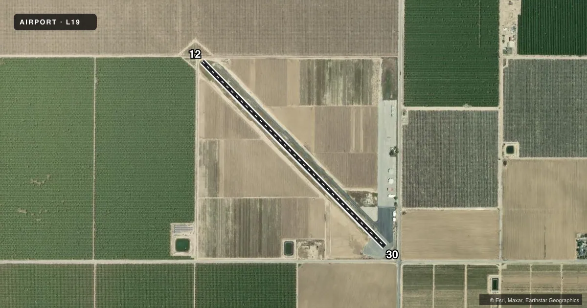
Airport sketch
Runways drawn to scale from FAA survey coordinates, rendered over satellite imagery. Not for navigation.
Approaches & charts
Services on the field
Fuel grades, oxygen, maintenance, ramp storage and lighting — as declared to the FAA by the airport operator.
Fuel & services
- Fuel
- 100LL
- Oxygen (bottled)
- Not available
- Oxygen (bulk)
- Not available
- Airframe repair
- Not available
- Power plant repair
- Not available
- Other services
- AGRI
Ramp & ground
- Transient storage
- Tie-down
- Landing fee
- No fee published
- Customs
- Not available
- Lighting schedule
- SEE RMK
- Beacon schedule
- SS-SR
- Beacon
- White / Green (civil land)(WG)
- Wind indicator
- Lighted
- Segmented circle
- Yes
Fuel & FBOs
Cheapest 100LL and Jet A on the field and nearby. Always confirm with the FBO before taxi.
Airport notes
Surface conditions, obstructions, local procedures, lighting outages and other notes published with each FAA cycle.
General notes
- CROP DUSTING OPNS PROHIBITED EXCP BY AMGR 661-393-1800.
- FOR CD CTC LOS ANGELES ARTCC AT 661-575-2079.
Lighting notes
- ACTVT MIRL RWY 12/30 - CTAF.
Runway surface & condition
- 12/30RY 12 LGTD THLD RELCTD 455 FT; RY 30 LGTD THLD RELCTD 240 FT FOR NIGHT OPNS; 2685 FT OF RY 12/30 USBL AT NIGHT.
Approach & departure obstructions
- 12+6' FENCE & +15' RD 0' TO 70' FM RY END 80' L TO 70' R.
- 30+4' FENCE 85' TO 180' FM RY END 125' L TO 125' R; +15' RD 105' TO 200' FM RY END 125' L TO 125' R; +8' SIGN 200' FM RY END 0' L.
- 12+35 FT POLES RIGHT TO LEFT 600 FT FM DSPLCD THLD. RY 12 APCH RATIO 18:1 TO DSPLCD THLD.
- 30RY 30 APCH RATIO 26:1 TO DSPLCD THLD.
Other notes
- ESTABD PRIOR TO 5/1/59.
- TPA 1113 MSL.
- MANAGERERIC GRANT, OPERATIONS MANAGER.
- MANAGERDIRECTOR, KERN COUNTY AIRPORTS
- MANAGER24 HR EMERG PHONE 661-747-4055.
VFR map & nearby airports
VFR sectional. Tap any ICAO chip to open that airport.
Key facts · L19
Answer card- ICAO
- L19
- Name
- WASCO-KERN COUNTY
- Location
- WASCO, CALIFORNIA
- Elevation
- 312 ft MSL
- Traffic pattern altitude
- 1,112 ft MSL (800 AGL)
- Control tower
- Non-towered (use CTAF)
- Total runways
- 1
- Longest runway
- 12/30 · 3,380 ft
- Published ILS approaches
- 0
- Published frequencies
- 2
- Magnetic variation
- 15°
- Current flight rules
- VFR
- Current wind
- 330° at 5 kt
- Favored runway now
- RWY 30
Wasco-Kern County Airport sits in Wasco, California. Field elevation is 312 ft MSL. The airport has one runway. Runway 12/30 is 3,380 ft long and paved with asphalt. There is no control tower. CTAF and UNICOM are both 122.8. No ILS approaches are published here.
Pattern altitude is 800 ft AGL, which is 1,112 ft MSL. That matters here because the field sits in the Central Valley with crop activity nearby. Published remarks say crop dusting is prohibited unless approved by the airport manager. If you are planning a first visit, call ahead and make sure you understand the local traffic picture before you arrive.
Night use needs a quick look at the remarks. Medium intensity runway lights on 12/30 are activated by CTAF. The runway 12 threshold is displaced 455 ft for night ops. The runway 30 threshold is displaced 240 ft for night ops. That leaves 2,685 ft usable at night. There are also obstructions near both runway ends, including fences, roads and a sign near runway 30. There are no on-field FBOs listed. Check with the airport operator or the FBO directly by phone for current services before you go.