METAR & TAF L73
L73 does not publish a METAR.
Showing the nearest reporting station: KBFL (MEADOWS FLD) · 10.4 NM away. Conditions at L73 may differ.
METAR · KBFL
Observed 18:54Z
KBFL 261854Z 27009KT 10SM CLR 32/12 A2997 RMK AO2 SLP143 T03170122 $
- Wind
- 270° @ 9 kt
- Visibility
- 10 SM
- Temp / Dew
- 32°C / 12°C
- Altimeter
- 29.97 inHg
- Clouds
- CLR
- Density alt
- 2,765 ft
- Ceiling
- Unlimited
- Rules
- VFR
Airport info & contacts
Manager on record, flight service, ARTCC, attendance schedule and pattern altitude — published by the FAA and refreshed every 28 days.
Location
- From city
- 4 NM E
- VFR sectional
- LOS ANGELES
- Pattern altitude
- 800 ft AGL · 1,435 ft MSL
- ARTCC
- ZLA · LOS ANGELES
- NOTAM facility
- RIU (NOTAM-D)
Airport manager
- Name
- BILL LAMANQUE
- Phone
- (661) 391-1824
- Address
- 3701 WINGS WAY, SUITE 300, BAKERSFIELD CA 93308-7026
Flight service · Hours
- FSS RIU
- RANCHO MURIETA1-800-WX-BRIEF
- Attendance
- Unattended
Frequencies
Tap any row to copy the frequency to your clipboard.
Runways & pattern
Full pagePattern entry · RWY 34
LEFT TRAFFICRunway end performance
| End | TORA | TODA | ASDA | LDA | VGSI | Approach lights | Obstruction |
|---|---|---|---|---|---|---|---|
| 16 | — | — | — | — | — | — | 15', trees, 621' from thr, 0' R of cntrln, slope 28 |
Declared distances in feet. TORA = takeoff run available, TODA = takeoff distance, ASDA = accelerate-stop, LDA = landing distance.
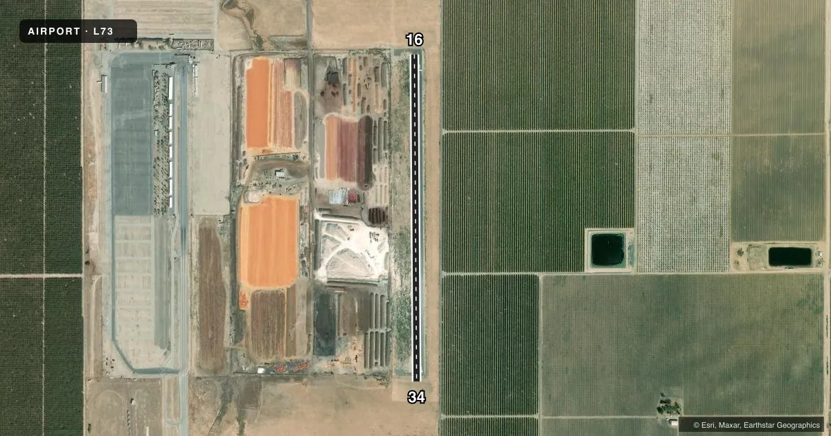
Airport sketch
Runways drawn to scale from FAA survey coordinates, rendered over satellite imagery. Not for navigation.
Approaches & charts
Services on the field
Fuel grades, oxygen, maintenance, ramp storage and lighting — as declared to the FAA by the airport operator.
Fuel & services
- Fuel
- Not available
- Oxygen (bottled)
- Not available
- Oxygen (bulk)
- Not available
- Airframe repair
- Not available
- Power plant repair
- Not available
Ramp & ground
- Transient storage
- Not published
- Landing fee
- No fee published
- Customs
- Not available
- Wind indicator
- Yes
- Segmented circle
- No
Fuel & FBOs
Cheapest 100LL and Jet A on the field and nearby. Always confirm with the FBO before taxi.
Airport notes
Surface conditions, obstructions, local procedures, lighting outages and other notes published with each FAA cycle.
General notes
- CROP DUSTING OPNS PROHIBITED EXCP BY PPR AMGR 661-391-1800.
- ARPT CLSD TO NIGHT OPNS.
- AREAS OF OPEN APRON ROUGH AND DETERIORATING.
- FOR CD CTC LOS ANGELES ARTCC AT 661-575-2079.
Approach & departure obstructions
- 16APCH RATIO 50:1 TO DSPLCD THR.
Other notes
- ESTABD PRIOR TO 5/1/59.
- MANAGERDIRECTOR, KERN COUNTY AIRPORTS
- MANAGER24 HR EMERG PHONE 661-747-4055.
VFR map & nearby airports
VFR sectional. Tap any ICAO chip to open that airport.
Key facts · L73
Answer card- ICAO
- L73
- Name
- POSO-KERN COUNTY
- Location
- FAMOSO, CALIFORNIA
- Elevation
- 635 ft MSL
- Traffic pattern altitude
- 1,435 ft MSL (800 AGL)
- Control tower
- Non-towered (use CTAF)
- Total runways
- 1
- Longest runway
- 16/34 · 3,000 ft
- Published ILS approaches
- 0
- Published frequencies
- 1
- Magnetic variation
- 15°
- Current flight rules
- VFR
- Current wind
- 270° at 9 kt
- Favored runway now
- RWY 34
POSO-KERN COUNTY (L73) is in Famoso, California. Field elevation is 635 ft MSL. The airport has one runway, 16/34, which is 3,000 ft long on asphalt. It is an uncontrolled field with no control tower. CTAF is 122.9.
Pattern altitude is 800 ft AGL, which is 1,435 ft MSL. No ILS approaches are published here, so plan with the current chart and your own situational awareness. The airport is closed to night operations, so do not plan an after-dark arrival or departure.
There are no on-field FBOs listed in the facts. Contact the airport operator directly before arrival, or call the field on CTAF for current service availability. Published remarks also note that crop dusting operations are prohibited unless you have prior permission from the manager. The open apron is rough and deteriorating, so taxi and parking deserve a careful look. There is also a published obstruction note for runway 16. The approach path has a 50-to-1 relationship to the displaced threshold, so brief that side of the runway before you go in. For clearance delivery, contact Los Angeles ARTCC using the number in the Chart Supplement.