METAR & TAF KBFL
Current METAR
Observed 05:54Z
KBFL 270554Z AUTO 33004KT 10SM CLR 26/08 A2992 RMK AO2 SLP124 T02610083 10372 20261 53013 $
- Wind
- 330° @ 4 kt
- Visibility
- 10 SM
- Temp / Dew
- 26°C / 8°C
- Altimeter
- 29.92 inHg
- Clouds
- CLR
- Density alt
- 1,952 ft
- Ceiling
- Unlimited
- Rules
- VFR
Airport info & contacts
Manager on record, flight service, ARTCC, attendance schedule and pattern altitude — published by the FAA and refreshed every 28 days.
Location
- From city
- 3 NM NW
- VFR sectional
- LOS ANGELES
- ARTCC
- ZLA · LOS ANGELES
- NOTAM facility
- BFL (NOTAM-D)
Airport manager
- Name
- BILL LAMANQUE
- Phone
- 661-747-4053
- Address
- 3701 WINGS WAY, #300, BAKERSFIELD CA 93308
Flight service · Hours
- FSS RIU
- RANCHO MURIETA1-800-WX-BRIEF
- Attendance
- ALL
Frequencies
Tap any row to copy the frequency to your clipboard.
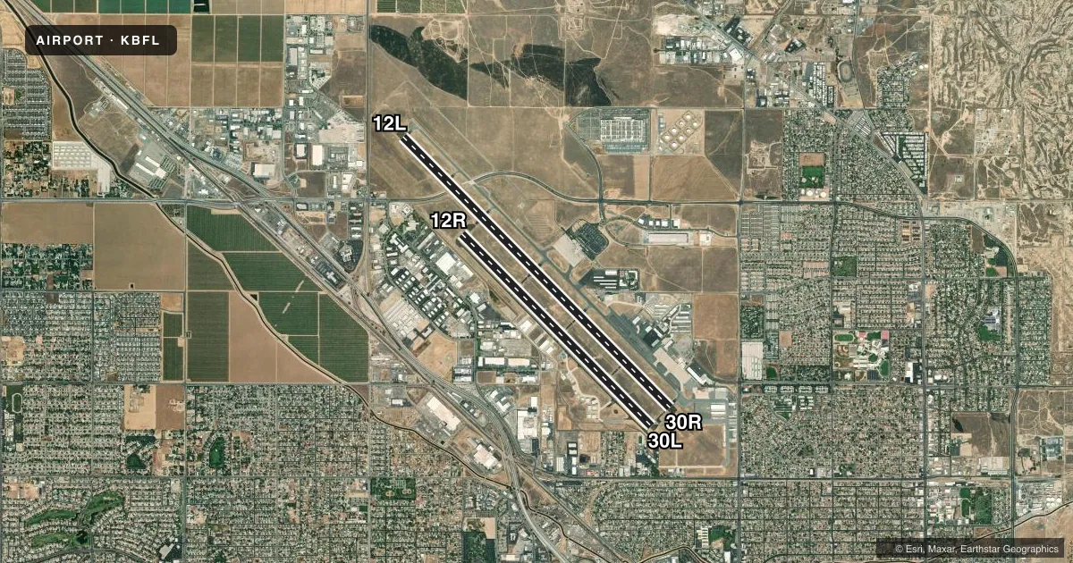
Runways & pattern
Full pagePattern entry · RWY 30R
RIGHT TRAFFIC| Runway | Heading (°M) | Length | Surface | Traffic |
|---|---|---|---|---|
| 12L/30RFavored | 121° / 301° | 10,849 ft | ASPH | 30R R |
| 12R/30L | 121° / 301° | 7,700 ft | ASPH | 12R R |
Runway end performance
| End | TORA | TODA | ASDA | LDA | VGSI | Approach lights | Obstruction |
|---|---|---|---|---|---|---|---|
| 12L | 10,849' | 10,849' | 10,849' | 10,849' | PAPI 4-box left(3°) | — | — |
| 30R | 10,849' | 10,849' | 10,849' | 7,430' | PAPI 4-box left(3°) | MALSR | — |
| 12R | 7,703' | 7,703' | 7,703' | 7,703' | PAPI 4-box left(3°) | — | — |
| 30L | 7,703' | 7,703' | 7,703' | 6,203' | PAPI 4-box left(3°) | — | 45', tree, 2150' from thr, 225' R of cntrln, slope 43 |
Declared distances in feet. TORA = takeoff run available, TODA = takeoff distance, ASDA = accelerate-stop, LDA = landing distance.
Airport sketch
Runways drawn to scale from FAA survey coordinates, rendered over satellite imagery. Not for navigation.
Approaches & charts
ILS · 1
Services on the field
Fuel grades, oxygen, maintenance, ramp storage and lighting — as declared to the FAA by the airport operator.
Fuel & services
- Fuel
- 100100LLA
- Oxygen (bottled)
- Low pressure
- Airframe repair
- Major
- Power plant repair
- Major
- Other services
- AFRT,AMB,AVNCS,CHTR,INSTR,RNTL,SALES,SURV
Ramp & ground
- Transient storage
- Tie-down
- Landing fee
- Yes
- Customs
- Not available
- Lighting schedule
- SEE RMK
- Beacon schedule
- SS-SR
- Beacon
- White / Green (civil land)(WG)
- Wind indicator
- Lighted
- Segmented circle
- Yes
Fuel & FBOs
Cheapest 100LL and Jet A on the field and nearby. Always confirm with the FBO before taxi.
Airport notes
Surface conditions, obstructions, local procedures, lighting outages and other notes published with each FAA cycle.
General notes
- MIL HELICOPTERS MAKE ALL APCHS TO RY OR PAVED AREAS. MINIMIZE HOVERING & POWER TO AVOID CAUSING BLOWING DUST; WHEELED HELICOPTERS GND TAXI ONLY. FORMATION JOIN-UP AFT DEP ONLY.
- CAP SQUADRON ON ARPT.
- RIGHT BASE OPNS FOR RY 30R ESTABLISH WINGS LEVEL ON FINAL APCH NO LOWER THAN 300 FT AGL.
- NOISE SENSITIVE AREAS S & E OF ARPT RECOMMENDED TURBOJET TRNG HRS WKDAY 0800-2200 WKENDS 1200-2200; NO MORE THAN TEN PRACTICE APCHS PER HR.
- RY 30R 50:1 TO DSPLD THLD.
- ARPT OPS NA BLO 1200 RVR WITHOUT SMGCS. ARPT OPS NOT INITIATED BLO 600 RVR OR AUTH BLO 500 RVR.
Lighting notes
- WHEN ATCT CLSD ACTVT MALSR RWY 30R; PAPI RWY 12L & 30R; HIRL RWY 12L/30R; TWY LGTS - CTAF. RWY 12R/30L CLSD WHEN ATCT CLSD.
Runway surface & condition
- 12L/30RPCR VALUE: 396/F/B/X/T
- 12R/30LPCR VALUE: 127/F/B/X/T
- 12R/30LRWY 12R/30L NOT AVBL FOR PART 121/PART 380 OPS WITH SKED PAX CARRYING OPS MORE THAN 9 PAX SEATS AND NON-SKED PAX CARRYING OPS MORE THAN 30 PAX SEATS.
Approach & departure obstructions
- 30RCNTRLN LGTS ARE ONLY VSB ON RWY 30R.
Other notes
- INDEX C ARFF AVAILABLE
- LDG FEE CHRGD TO ALL AIR TAXI, COML ACFT OPS (EXC FLT INSTRN), AND TSNT ACFT WEIGHING MORE THAN 10000 LBS.
- MANAGERCELL PHONE: 661-747-4053; H24 CTC: 661-747-4053; FAX: 661-391-1801; EMAIL: LAMANQUEBI@KERNCOUNTY.COM.
- OWNERBILL LAMANQUE - LAMANQUEBI@KERNCOUNTY.COM
VFR map & nearby airports
VFR sectional. Tap any ICAO chip to open that airport.
Key facts · KBFL
Answer card- ICAO
- KBFL
- Name
- MEADOWS FLD
- Location
- BAKERSFIELD, CALIFORNIA
- Elevation
- 509.6 ft MSL
- Traffic pattern altitude
- 1,509.6 ft MSL (1,000 AGL)
- Control tower
- Towered · 0600-2300
- Total runways
- 2
- Longest runway
- 12L/30R · 10,849 ft
- Published ILS approaches
- 1
- Published frequencies
- 13
- Magnetic variation
- 14°
- Current flight rules
- VFR
- Current wind
- 330° at 4 kt
- Favored runway now
- RWY 30R
Meadows Fld sits in Bakersfield, California at 509.6 ft MSL. It has two asphalt runways. The longest is 12L/30R at 10,849 ft. The other runway is 12R/30L at 7,700 ft. The tower is open daily from 0600 to 2300. One ILS is published for runway 30R. Pattern altitude is not published in the facts, so verify the current Chart Supplement before you go. For light piston traffic, use the standard 1,000 ft AGL pattern only if the current published data supports it.
Three on-field FBOs are listed. Bakersfield Jet Center carries 100LL, Jet A and Jet A Prist. Atlantic Aviation carries 100LL and Jet A. Epic Jet Center carries 100LL, Jet A and Jet A Prist. This field also has a few operational items worth planning for. When the tower is closed, runway 12R/30L is closed. Runway 30R has centerline lights. Noise sensitive areas are south and east of the airport. Turbojet training is recommended on weekdays from 0800 to 2200. Weekend training is recommended from 1200 to 2200. The field is in a busy Bakersfield environment, so brief the tower. Watch your spacing. Expect a controlled airport flow. Military helicopters use paved surfaces. Keep hover power and dust down.