METAR & TAF KTSP
Current METAR
Observed 06:15Z
KTSP 270615Z AUTO 27008KT 10SM CLR 21/05 A3016 RMK AO2
- Wind
- 270° @ 8 kt
- Visibility
- 10 SM
- Temp / Dew
- 21°C / 5°C
- Altimeter
- 30.16 inHg
- Clouds
- CLR
- Density alt
- 5,384 ft
- Ceiling
- Unlimited
- Rules
- VFR
Airport info & contacts
Manager on record, flight service, ARTCC, attendance schedule and pattern altitude — published by the FAA and refreshed every 28 days.
Location
- From city
- 0 NM NE
- VFR sectional
- LOS ANGELES
- ARTCC
- ZLA · LOS ANGELES
- NOTAM facility
- RIU (NOTAM-D)
Airport manager
- Name
- ASHLEY WHITMORE
- Phone
- (661) 822-2200
- Address
- 115 SOUTH ROBINSON STREET, TEHACHAPI CA 93561
Flight service · Hours
- FSS RIU
- RANCHO MURIETA1-800-WX-BRIEF
- Attendance
- 0700-1730
Frequencies
Tap any row to copy the frequency to your clipboard.
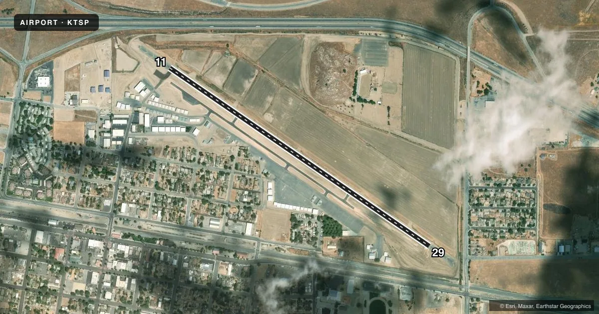
Runways & pattern
Full pagePattern entry · RWY 29
LEFT TRAFFICRunway end performance
| End | TORA | TODA | ASDA | LDA | VGSI | Approach lights | Obstruction |
|---|---|---|---|---|---|---|---|
| 11 | — | — | — | — | PAPI 2-box left(3°) | — | 276', hill, 4800' from thr, 0' R of cntrln, slope 16 |
| 29 | — | — | — | — | PAPI 2-box left(3.5°) | — | 32', rr, 635' from thr, 165' R of cntrln, slope 13 |
Declared distances in feet. TORA = takeoff run available, TODA = takeoff distance, ASDA = accelerate-stop, LDA = landing distance.
Airport sketch
Runways drawn to scale from FAA survey coordinates, rendered over satellite imagery. Not for navigation.
Approaches & charts
Services on the field
Fuel grades, oxygen, maintenance, ramp storage and lighting — as declared to the FAA by the airport operator.
Fuel & services
- Fuel
- 100LLA
- Oxygen (bulk)
- Not available
- Airframe repair
- Major
- Power plant repair
- Major
- Other services
- INSTR,RNTL
Ramp & ground
- Transient storage
- Tie-down
- Landing fee
- No fee published
- Customs
- Not available
- Lighting schedule
- SEE RMK
- Beacon schedule
- SS-SR
- Beacon
- White / Green (civil land)(WG)
- Wind indicator
- Lighted
- Segmented circle
- Yes
Fuel & FBOs
Cheapest 100LL and Jet A on the field and nearby. Always confirm with the FBO before taxi.
Airport notes
Surface conditions, obstructions, local procedures, lighting outages and other notes published with each FAA cycle.
General notes
- LGTD OBSTN/MOUNTAIN/1 MI WEST OF ARPT (4279' MSL).
- FOR CD CTC LOS ANGELES ARTCC AT 661-575-2079.
Lighting notes
- ACTVT HIRL RY 11/29 - CTAF.
Fuel notes
- 100LLFUEL 24 HRS CREDIT CARD.
Runway surface & condition
- 11/29GWT PAVEMENT STRENGTH PRVDD BY ARPT MANAGER: 25000 LBS.
Approach & departure obstructions
- 29UNUSBL BYD 4 NM DUE TO TRRN.
- 11APCH RATIO TO DSPLCD THR 18:1.
- 29APCH RATIO TO DSPLCD THR 31:1.
Other notes
- ESTABD PRIOR TO 1959.
- 2FOR AFTER HRS OR EMERG CALL 661-822-2222
- MANAGEROFC 661-822-2200 X101. AFTER HOURS 661-822-2222.
VFR map & nearby airports
VFR sectional. Tap any ICAO chip to open that airport.
Key facts · KTSP
Answer card- ICAO
- KTSP
- Name
- TEHACHAPI MUNI
- Location
- TEHACHAPI, CALIFORNIA
- Elevation
- 4,001.1 ft MSL
- Traffic pattern altitude
- 5,001.1 ft MSL (1,000 AGL)
- Control tower
- Non-towered (use CTAF)
- Total runways
- 1
- Longest runway
- 11/29 · 4,040 ft
- Published ILS approaches
- 0
- Published frequencies
- 2
- Magnetic variation
- 14°
- Current flight rules
- VFR
- Current wind
- 270° at 8 kt
- Favored runway now
- RWY 29
Tehachapi Muni sits in Tehachapi, California at 4,001.1 ft MSL. It has one runway, 11/29, which is 4,040 ft long and asphalt. There is no control tower. CTAF and UNICOM are both 123.0. No ILS approaches are published here.
Pattern altitude is not published. Use the standard 1,000 ft AGL for light piston traffic unless the current Chart Supplement says otherwise. The airport is in a mountain setting. There is a lighted obstruction and mountain 1 mile west of the field at 4,279 ft MSL. Runway 29 is also limited beyond 4 NM because of terrain. That matters on arrival and departure planning.
The on-field FBO is Tehachapi Municipal Airport. It carries 100LL and Jet A Prist. Fuel is available 24 hours with credit card. High intensity runway lights on 11/29 are activated by CTAF. The published gross weight pavement strength for 11/29 is 25,000 pounds. For clearance delivery, contact Los Angeles ARTCC. If you need the office or after-hours line, use the airport numbers in the Chart Supplement or call the airport operator directly. This is a high-elevation field, so expect density altitude to be a real factor on warm days.