METAR & TAF L00
L00 does not publish a METAR.
Showing the nearest reporting station: KWJF (GENERAL WM J FOX AIRFIELD) · 7.8 NM away. Conditions at L00 may differ.
METAR · KWJF
Observed 03:56Z
KWJF 270356Z AUTO 27016KT 10SM CLR 29/02 A2999 RMK AO2 SLP128 T02940022 $
- Wind
- 270° @ 16 kt
- Visibility
- 10 SM
- Temp / Dew
- 29°C / 2°C
- Altimeter
- 29.99 inHg
- Clouds
- CLR
- Density alt
- 4,588 ft
- Ceiling
- Unlimited
- Rules
- VFR
Airport info & contacts
Manager on record, flight service, ARTCC, attendance schedule and pattern altitude — published by the FAA and refreshed every 28 days.
Location
- From city
- 3 NM W
- VFR sectional
- LOS ANGELES
- ARTCC
- ZLA · LOS ANGELES
- NOTAM facility
- RAL (NOTAM-D)
Airport manager
- Name
- JOHN WILSON
- Phone
- 661-475-2600
- Address
- ROSAMOND SKYPARK ASSOCIATION, 4000 KNOX AVENUE, ROSAMOND CA 93560
Flight service · Hours
- FSS RAL
- RIVERSIDE1-800-WX-BRIEF
- Attendance
- Unattended
Frequencies
Tap any row to copy the frequency to your clipboard.
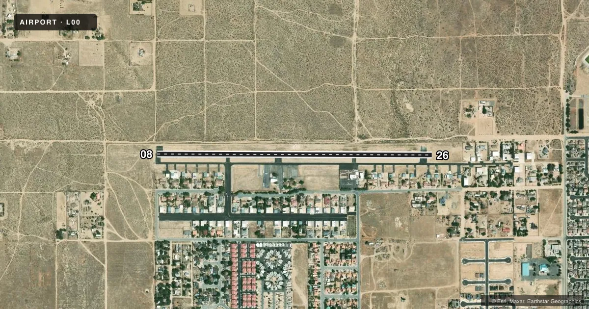
Runways & pattern
Full pagePattern entry · RWY 26
LEFT TRAFFICRunway end performance
| End | TORA | TODA | ASDA | LDA | VGSI | Approach lights | Obstruction |
|---|---|---|---|---|---|---|---|
| 26 | — | — | — | — | — | — | 40', trees, 625' from thr, 0' R of cntrln, slope 10 |
Declared distances in feet. TORA = takeoff run available, TODA = takeoff distance, ASDA = accelerate-stop, LDA = landing distance.
Airport sketch
Runways drawn to scale from FAA survey coordinates, rendered over satellite imagery. Not for navigation.
Approaches & charts
Services on the field
Fuel grades, oxygen, maintenance, ramp storage and lighting — as declared to the FAA by the airport operator.
Fuel & services
- Fuel
- 100LL
- Oxygen (bottled)
- Not available
Ramp & ground
- Transient storage
- Tie-down
- Landing fee
- No fee published
- Customs
- Not available
- Lighting schedule
- SEE RMK
- Beacon schedule
- SEE RMK
- Beacon
- White / Green (civil land)(WG)
- Wind indicator
- Lighted
- Segmented circle
- Yes
Fuel & FBOs
Cheapest 100LL and Jet A on the field and nearby. Always confirm with the FBO before taxi.
Airport notes
Surface conditions, obstructions, local procedures, lighting outages and other notes published with each FAA cycle.
General notes
- MAINTAIN RY HEADING UNTIL REACHING ARPT BOUNDARY.
- AVOID OVERFLIGHT OF SCHOOLS 1 MILE E AND 2 MILES W.
- GLIDERS; ULTRALIGHTS & HELICOPTERS TFC PAT NORTH OF RY.
- NO TOUCH & GO LNDGS BETWEEN 2200 & 0700 LOCAL.
- POWERED ACFT ONLY MAY USE SOUTH TFC PAT.
- CALM WIND USE RY 26.
- TERRAIN APPROX 3,200 FEET MSL 2 MILES NORTH-EAST AND 3 MILES NORTHWEST OF ARPT.
- ARPT USE RSTRD BY AMGR TO ACFT HAVING A MAX CERTIFICATED GROSS TKOF WGT OF 12500 LBS OR LESS; CTC AMGR FOR ADDNL INFO 661-475-2600.
- FOR CD CTC JOSHUA APCH AT 661-277-3843.
Lighting notes
- ROTG BCN OTS INDEFLY.
- ROTG BCN OTS INDEFLY.
- AFT 11PM LCL ACTVT LIRL RWY 08/26 5 CLICKS - CTAF.
Runway surface & condition
- 08/26RY 08/26 NSTD LIRL 25 FT FM EDGE OF RY.
Approach & departure obstructions
- 08APCH RATIO 50:1 TO DSPLCD THLD.
- 26APCH RATIO 20:1 TO DSPLCD THLD.
Other notes
- ESTABD PRIOR 5/15/59.
- AUTOMATED UNICOM; 4 CLICKS ADZY.
- GLIDER TFC PATTERN ALT 500'.
- MANAGERSECRETARY, BOARD OF DIRECTORS: JOHN WILSON, ROSAMOND SKYPARK ASSN PHONE 661-256-4600; EMAIL ADMIN@SKYPARK.ORG.
VFR map & nearby airports
VFR sectional. Tap any ICAO chip to open that airport.
Key facts · L00
Answer card- ICAO
- L00
- Name
- ROSAMOND SKYPARK
- Location
- ROSAMOND, CALIFORNIA
- Elevation
- 2,415 ft MSL
- Traffic pattern altitude
- 3,415 ft MSL (1,000 AGL)
- Control tower
- Non-towered (use CTAF)
- Total runways
- 1
- Longest runway
- 08/26 · 3,600 ft
- Published ILS approaches
- 0
- Published frequencies
- 1
- Magnetic variation
- 14°
- Current flight rules
- VFR
- Current wind
- 270° at 16 kt
- Favored runway now
- RWY 26
Rosamond Skypark is in Rosamond, California. The field elevation is 2,415 ft MSL. It has one runway. The longest runway is 3,600 ft of asphalt. There is no control tower. CTAF is 122.9. No ILS approaches are published.
The pattern altitude is not published for powered aircraft in the facts, so use the standard 1,000 ft AGL unless the current Chart Supplement or airport manager says otherwise. Glider traffic pattern altitude is 500 ft. The airport is restricted by the airport manager to aircraft with a maximum certificated gross takeoff weight of 12,500 lb or less. Contact the airport manager for details before you go.
Lofty is on the field. Fuel grades are not reported, so call the FBO directly at (805) 469-6031 for current availability. The rotating beacon is out of service indefinitely. Runway 08/26 has nonstandard low intensity lights set 25 ft from the runway edge. Terrain rises to about 3,200 ft MSL about 2 miles northeast and 3 miles northwest of the airport. For clearance delivery, contact Joshua Approach at 661-277-3843. Use runway 26 when winds are calm. Gliders, ultralights and helicopters use the north pattern. Powered aircraft use the south pattern. Maintain runway heading until reaching the airport boundary.