METAR & TAF L70
L70 does not publish a METAR.
Showing the nearest reporting station: KPMD (PALMDALE USAF PLANT 42) · 13.6 NM away. Conditions at L70 may differ.
METAR · KPMD
Observed 07:53Z
KPMD 270753Z AUTO 23007KT 10SM CLR 25/08 A3001 RMK AO2 SLP128 T02500083 403720217 $
- Wind
- 230° @ 7 kt
- Visibility
- 10 SM
- Temp / Dew
- 25°C / 8°C
- Altimeter
- 30.01 inHg
- Clouds
- CLR
- Density alt
- 4,353 ft
- Ceiling
- Unlimited
- Rules
- VFR
Airport info & contacts
Manager on record, flight service, ARTCC, attendance schedule and pattern altitude — published by the FAA and refreshed every 28 days.
Location
- From city
- 2 NM E
- VFR sectional
- LOS ANGELES
- ARTCC
- ZLA · LOS ANGELES
- NOTAM facility
- RAL (NOTAM-D)
Airport manager
- Name
- JON BONNER
- Phone
- (661) 268-8835
- Address
- 33638 AGUA DULCE CANYON ROAD, P. O. BOX 9203, AGUA DULCE CA 91390
Flight service · Hours
- FSS RAL
- RIVERSIDE1-800-WX-BRIEF
- Attendance
- 0800-1800
Frequencies
Tap any row to copy the frequency to your clipboard.
Runways & pattern
Full pagePattern entry · RWY 22
RIGHT TRAFFICRunway end performance
| End | TORA | TODA | ASDA | LDA | VGSI | Approach lights | Obstruction |
|---|---|---|---|---|---|---|---|
| 04 | — | — | — | — | — | — | 15', bldg, 240' from thr, 85' R of cntrln, slope 2 |
| 22 | — | — | — | — | — | — | 4', fence, 200' from thr, 35' R of cntrln, slope 0 |
Declared distances in feet. TORA = takeoff run available, TODA = takeoff distance, ASDA = accelerate-stop, LDA = landing distance.
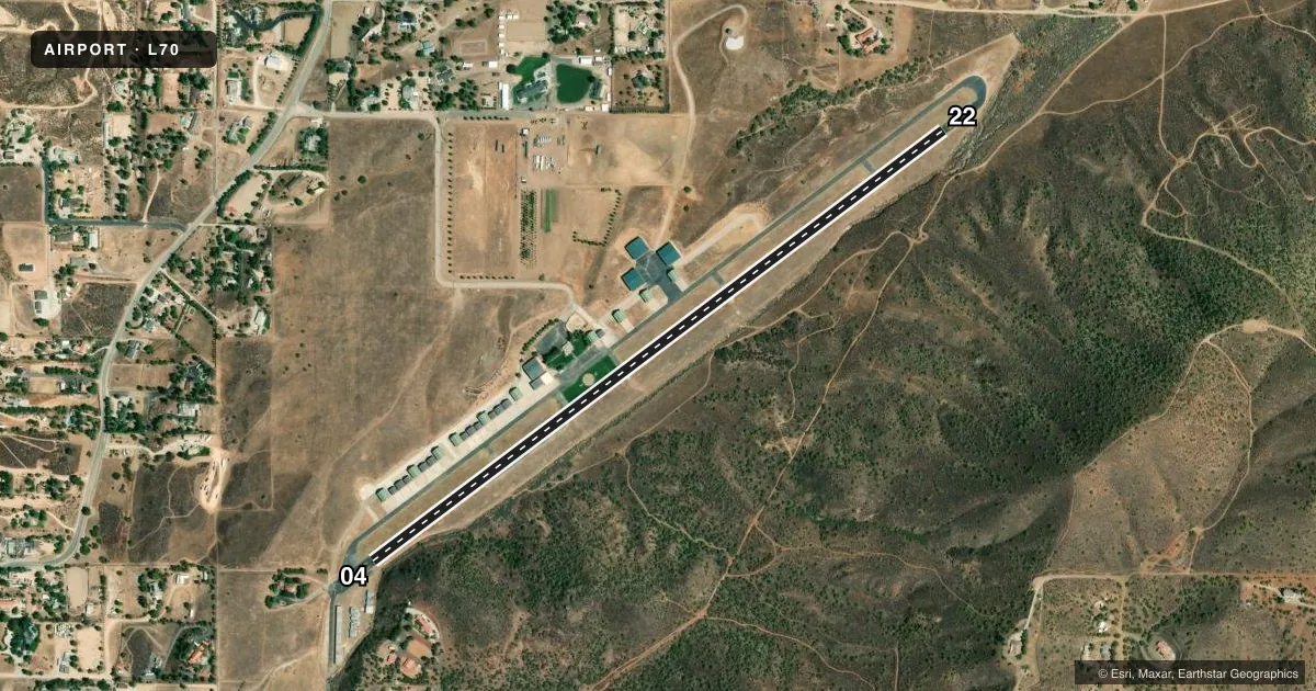
Airport sketch
Runways drawn to scale from FAA survey coordinates, rendered over satellite imagery. Not for navigation.
Approaches & charts
Services on the field
Fuel grades, oxygen, maintenance, ramp storage and lighting — as declared to the FAA by the airport operator.
Fuel & services
- Fuel
- 100LL
- Oxygen (bottled)
- Not available
- Oxygen (bulk)
- Not available
- Airframe repair
- Not available
- Power plant repair
- Not available
Ramp & ground
- Transient storage
- Tie-down
- Landing fee
- No fee published
- Customs
- Not available
- Wind indicator
- Yes
- Segmented circle
- Yes
Fuel & FBOs
Cheapest 100LL and Jet A on the field and nearby. Always confirm with the FBO before taxi.
Airport notes
Surface conditions, obstructions, local procedures, lighting outages and other notes published with each FAA cycle.
General notes
- RIDGE SOUTH OF AIRPORT PARALLEL TO RY VIOLATES 7:1 TRANSITIONAL SURFACE.
- 10-25 FT WIDE DITCH AT 170 FT ALONG SE EDGE OF RY.
- TGL NOT PERMITTED.
- AVOID FLYING WITHIN 1000 FT OF SCHOOL APRXLY ONE MILE SOUTHWEST. RY 04 DEP AVOID FLYING OVER HOMES 2,000 FT NE OF RY END.
- FORMATION ARRIVALS AND DEPARTURES PROHIBITED.
- NO AEROBATICS PERMITTED.
- AIRPORT CLSD SUNSET TO SUNRISE. ALL NIGHT OPERATIONS PROHIBITED BY LOCAL RESTRICTIONS.
- ACTVT MIKE 5 TIMES ON CTAF FREQ FOR ARPT WX.
- FOR CD CTC JOSHUA APCH AT 661-277-3843.
Fuel notes
- 100LLSELF SERVICE
Approach & departure obstructions
- 04RWY 04 +15 FT HANGER 140-160 FT FM EOR 80 FT RIGHT.
- 22+4 FT FENCE 0 FT - 200 FT FROM EOR DIAGONALLY FROM 50 FT LEFT TO 35 FT RIGHT.
- 04RWY 04 APCH RATIO TO DSPLCD THLD 20:1 (DSPLCD THLD IS 5 FT HIGHER THAN EOR); APCH RATIO TO DSPLCD THLD OVER +15 FT HILL 300 FT FM DSPLCD THLD 150 FT RIGHTR 20:1.
- 22APCH RATIO TO DSPLCD THR 50:1; APCH RATIO TO DSPLCD THR OVER +300 FT HILL 4700 FT FROM DSPLCD THR 0FT LEFT AND RIGHT 15:1.
Other notes
- 1AIRPORT UNATNDD CHRISTMAS DAY; THANKSGIVING DAY AND NEW YEARS DAY.
- MANAGERDOUG ABNEY, ASST ARPT OPNS - PHONE 661-268-8835 CELL 661-268-8835. EMAIL: SUPPORT@L70AIRPORT.COM
VFR map & nearby airports
VFR sectional. Tap any ICAO chip to open that airport.
Key facts · L70
Answer card- ICAO
- L70
- Name
- AGUA DULCE
- Location
- AGUA DULCE, CALIFORNIA
- Elevation
- 2,633 ft MSL
- Traffic pattern altitude
- 3,633 ft MSL (1,000 AGL)
- Control tower
- Non-towered (use CTAF)
- Total runways
- 1
- Longest runway
- 04/22 · 4,205 ft
- Published ILS approaches
- 0
- Published frequencies
- 2
- Magnetic variation
- 14°
- Current flight rules
- VFR
- Current wind
- 230° at 7 kt
- Favored runway now
- RWY 22
Agua Dulce Airport sits in Agua Dulce, California. The field elevation is 2,633 ft MSL. It has one runway, 04/22, which is 4,205 ft long and asphalt. There is no control tower. CTAF and UNICOM are both 122.8. No ILS approaches are published here.
Pattern altitude is not published. Use the standard 1,000 ft AGL for light piston traffic unless the current FAA Chart Supplement says otherwise. That puts the pattern at 3,633 ft MSL based on the field elevation. The on-field FBO is Agua Dulce Airport. It carries 100LL. The remarks say the 100LL is self-serve.
This is a field where local terrain matters. The published remarks note a ridge south of the airport that breaks the 7 to 1 transitional surface. They also note a ditch along the southeast edge of the runway near the departure end. Runway 04 has displaced-threshold-related obstacle notes. Runway 22 has a fence near the end of the runway and a hill farther out on the approach path. No aerobatics are permitted. Touch-and-go landings are not permitted. Formation arrivals and departures are prohibited. For clearance delivery, contact Joshua Approach. For airport weather, activate Mike five times on CTAF.