METAR & TAF KBUR
Current METAR
Observed 05:53Z
KBUR 270553Z 13006KT 10SM CLR 24/17 A2994 RMK AO2 SLP125 T02390167 10350 20239 51016 $
- Wind
- 130° @ 6 kt
- Visibility
- 10 SM
- Temp / Dew
- 24°C / 17°C
- Altimeter
- 29.94 inHg
- Clouds
- CLR
- Density alt
- 2,020 ft
- Ceiling
- Unlimited
- Rules
- VFR
Airport info & contacts
Manager on record, flight service, ARTCC, attendance schedule and pattern altitude — published by the FAA and refreshed every 28 days.
Location
- From city
- 3 NM NW
- VFR sectional
- LOS ANGELES
- ARTCC
- ZLA · LOS ANGELES
- NOTAM facility
- BUR (NOTAM-D)
Airport manager
- Name
- KEENAN CUMMINGS
- Phone
- 818-840-8830
- Address
- 2627 HOLLYWOOD WAY, BURBANK CA 91505
Flight service · Hours
- FSS HHR
- HAWTHORNE1-800-WX-BRIEF
- Attendance
- ALL
Frequencies
Tap any row to copy the frequency to your clipboard.
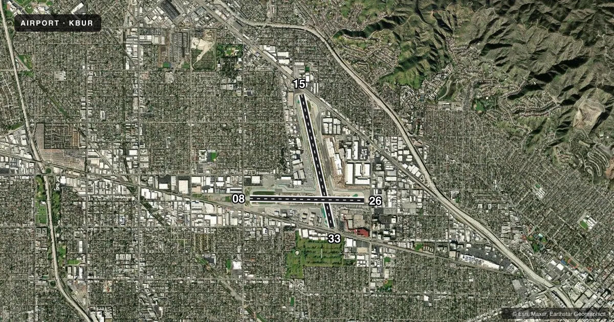
Runways & pattern
Full pagePattern entry · RWY 15
RIGHT TRAFFIC| Runway | Heading (°M) | Length | Surface | Traffic |
|---|---|---|---|---|
| 15/33Favored | 155° / 335° | 6,886 ft | ASPH-CONC | 15 R |
| 08/26 | 79° / 259° | 5,802 ft | ASPH-CONC | 08 R |
Runway end performance
| End | TORA | TODA | ASDA | LDA | VGSI | Approach lights | Obstruction |
|---|---|---|---|---|---|---|---|
| 15 | 6,885' | 6,885' | 6,885' | 5,976' | PAPI 4-box left(3.25°) | — | 30', rr, 200' from thr, 250' R of cntrln, slope 0 |
| 33 | 6,885' | 6,885' | 6,885' | 6,535' | PAPI 4-box left(3.2°) | — | 31', pole, 201' from thr, 240' R of cntrln, slope 0 |
| 08 | 5,801' | 5,801' | 5,801' | 5,801' | PAPI 4-box left(3°) | MALSR | 14', road, 300' from thr, 0' R of cntrln, slope 7 |
| 26 | 5,801' | 5,801' | 5,801' | 5,801' | — | — | 40', pole, 245' from thr, 410' R of cntrln, slope 1 |
Declared distances in feet. TORA = takeoff run available, TODA = takeoff distance, ASDA = accelerate-stop, LDA = landing distance.
Airport sketch
Runways drawn to scale from FAA survey coordinates, rendered over satellite imagery. Not for navigation.
Approaches & charts
ILS · 1
Services on the field
Fuel grades, oxygen, maintenance, ramp storage and lighting — as declared to the FAA by the airport operator.
Fuel & services
- Fuel
- 100LLAA+UL94
- Oxygen (bottled)
- High pressure
- Oxygen (bulk)
- High pressure
- Airframe repair
- Major
- Power plant repair
- Major
- Other services
- AFRT,AVNCS,CARGO,CHTR,INSTR,RNTL,SALES
Ramp & ground
- Transient storage
- Hangar
- Landing fee
- No fee published
- Customs
- Not available
- Beacon schedule
- SS-SR
- Beacon
- White / Green (civil land)(WG)
- Wind indicator
- Lighted
- Segmented circle
- No
Fuel & FBOs
Cheapest 100LL and Jet A on the field and nearby. Always confirm with the FBO before taxi.
Airport notes
Surface conditions, obstructions, local procedures, lighting outages and other notes published with each FAA cycle.
General notes
- ACFT IN TFC PAT (1225 FT AGL) AT WHITEMAN AIRPARK 5 MI NW.
- TURBULENT CONDS NEAR ARPT AT TIMES OF HIGH WINDS FROM NORTH & EAST. DOWNDRAFTS/WINDSHEAR MAY OCCUR AT LIFTOFF OR ON FINAL.
- BIRD ACTIVITY NORTH END RY 15/33 AND WEST END RY 08/26.
- RWY 08 CLSD TKOF ACFT GTR THAN 12500 LBS.
- HANG GLIDER ACTIVITY BTN 5 & 10 NM NORTH OF ARPT 6000 FT AGL SR-SS.
- TWY G RSTRD TO ACFT WITH WINGSPAN OF 95 FT OR LESS.
- POWER ENGINE RUN-UPS FOR ACFT GTR THAN 1200 LBS PROHIBITED IN ALL AREAS EXC ON TWY D RUN-UP AREA OR AS COORDINATED WITH ATCT.
- 14 FT BLAST FENCE 35 FT FM DEP END RY 15.
- 14 FT BLAST FENCE 93 FT FM DEP END RY 33.
- 8 FT BLAST FENCE 260 FT FM DEP END OF RY 26.
- 14 FT BLAST FENCE 256 FT FROM DEP END RY 08.
- TWY A RESTRICTED TO ACFT WITH WINGSPAN OF 171 FT OR LESS.
- PILOTS SHOULD CALL AHEAD FOR ARPT NOISE RULES (818) 840-8840.
- RSTRNS AND FINES EFF 2200-0700 FOR STAGE 2 JETS, CERTAIN PROPS, RUN-UPS AND FLT TRG ACT, CALL (818) 840-8840 BFR OPRG.
- TWY B RESTRICTED TO ACFT WITH WINGSPAN OF 79 FT OR LESS BEGINNING 300 FT NORTH OF TWY D AND CONTINUING NORTH.
- NO GA ACFT PARKING AT TERMINAL RAMP.
- ACFT WILL USE EASY PWR WHEN LVG ASGND GATE. CTN MUST BE USED WHEN TAXIING FM TRML AREA DUE TO CLOSE PROXIMITY TO THE TRML. PSNL AND GND EQUIP IN AREA.
- ACFT WITH WINGSPAN GTR THAN 95 FT EXP BACK TAXI ON RWY 15/33 FOR A RWY 33 DEP.
- ACFT RSTRD FROM TAXIING SB PAST GATE B1 ON TRML RAMP.
- ACFT WITH WINGSPAN GTR THAN 79 FT RSTRD FROM USING TWY C W OF TWY C8.
- RWY 26 CLSD TO TKOF/JET ACFT WITH FOUR OR MORE ENGS.
- X-BLEED STARTS PROHIBITED IN ALL NON-MOVMT AREAS INCLG THE AIRLINE TRML RAMP. ATC MAY APV X-BLEED STARTS ON TWY A NORTH OF TWY D, ALL OTHER REQS MUST BE COORDD AND APVD BY OPS.
- WHEN KBUR LDG RWY 08 USE CTN FOR TCAS RA DUE TO ACFT IN KVNY RWY 16L/34R TFC PAT (TPA 1802 MSL).
Runway surface & condition
- 08/26PCR VALUE: 611/F/C/X/T
- 15/33PCR VALUE: 685/F/C/X/T
Approach & departure obstructions
- 15+15 FT ROAD 100-200 FT FROM RY END; +14 FT BLAST FENCE; MULTIPLE LIGHT STANDARDS 15 FT FROM END OF RY.
- 26+28' SIGN 90 FT FM RY THLD, +14 FT BLAST FENCE AT THLD.
- 33+20 FT POLE 198 FT FROM RY THR; +14 FT BLAST FENCE AT THR.
- 08PAPI UNUSBL BYD 6.5 DEGS LEFT OF RWY CNTRLN.
- 15UNUSBL BYD 5 DEGS LEFT OF CNTRLN.
- 33PAPI UNUSBL BYD 2 DEG RIGHT OF CNTRLN.
- 15APCH RATIO 36:1 TO DSPLCD THR.
- 26RWY 26 APCH RATIO 11:1 TO THR.
- 33APCH RATIO 22:1 TO DSPLCD THR.
Arresting gear
- 08_EMASENGINEERED MATERIAL ARRESTING SYSTEM (EMAS) 170 FT LENGTH BY 350 FT WIDTH LCTD AT THE DER 08.
Other notes
- ESTABD PRIOR TO 1959.
- MANAGERDIRECTOR OF OPS
VFR map & nearby airports
VFR sectional. Tap any ICAO chip to open that airport.
Key facts · KBUR
Answer card- ICAO
- KBUR
- Name
- BOB HOPE
- Location
- BURBANK, CALIFORNIA
- Elevation
- 778 ft MSL
- Traffic pattern altitude
- 1,778 ft MSL (1,000 AGL)
- Control tower
- Towered · 24
- Total runways
- 2
- Longest runway
- 15/33 · 6,886 ft
- Published ILS approaches
- 1
- Published frequencies
- 29
- Magnetic variation
- 12°
- Current flight rules
- VFR
- Current wind
- 130° at 6 kt
- Favored runway now
- RWY 15
Bob Hope Airport is in Burbank, California. It sits at 778 ft MSL. KBUR has two runways. The longest is 15/33 at 6,886 ft. The airport has a control tower. Tower service is listed as 24 hours. One ILS approach is published for runway 08.
For pattern work, the facts block does not publish a pattern altitude for KBUR. Use the current FAA Chart Supplement before you fly. The field has two on-field FBOs. Atlantic Aviation is on the field and carries 100LL and Jet A. Hollywood Burbank Jet Jenter is also on the field and carries 100LL, Jet A and Jet A Prist. Call ahead if you need current ramp handling or fuel service details.
This is a busy Southern California airport. The published remarks matter. Aircraft with a wingspan over 79 ft have taxi limits on parts of the field. Runway 15 has a note that it is unusable beyond 5 degrees left of centerline. There is also an EMAS at the departure end of runway 08. Pilots should call ahead for airport noise rules. The airport also restricts general aviation parking on the terminal ramp. If you are new to KBUR, brief the taxi plan before engine start. Verify the current Chart Supplement for any local procedures.