METAR & TAF KVNY
Current METAR
Observed 11:51Z
KVNY 271151Z AUTO 00000KT 10SM CLR 22/16 A2992 RMK AO2 SLP120 T02170161 10250 20211 55003
- Wind
- 000° @ 0 kt
- Visibility
- 10 SM
- Temp / Dew
- 22°C / 16°C
- Altimeter
- 29.92 inHg
- Clouds
- CLR
- Density alt
- 1,835 ft
- Ceiling
- Unlimited
- Rules
- VFR
Airport info & contacts
Manager on record, flight service, ARTCC, attendance schedule and pattern altitude — published by the FAA and refreshed every 28 days.
Location
- From city
- 3 NM NW
- VFR sectional
- LOS ANGELES
- ARTCC
- ZLA · LOS ANGELES
- NOTAM facility
- VNY (NOTAM-D)
Airport manager
- Name
- JACOB HAIK
- Phone
- 818-442-6500
- Address
- 16461 SHERMAN WY SUITE 300, VAN NUYS CA 91406
Flight service · Hours
- FSS HHR
- HAWTHORNE1-800-WX-BRIEF
- Attendance
- ALL
Frequencies
Tap any row to copy the frequency to your clipboard.
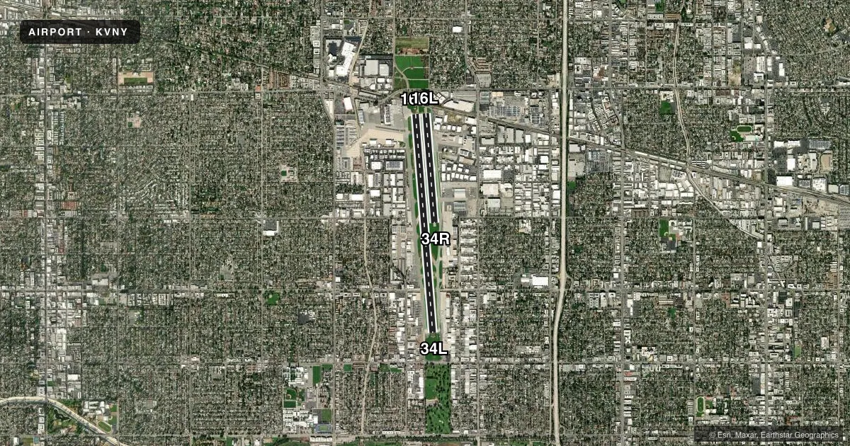
Runways & pattern
Full pagePattern entry · RWY 16R
RIGHT TRAFFIC| Runway | Heading (°M) | Length | Surface | Traffic |
|---|---|---|---|---|
| 16R/34L | 164° / 344° | 8,001 ft | ASPH | 16R R |
| 16L/34R | 164° / 344° | 4,013 ft | ASPH | 34R R |
Runway end performance
| End | TORA | TODA | ASDA | LDA | VGSI | Approach lights | Obstruction |
|---|---|---|---|---|---|---|---|
| 16R | 8,001' | 8,001' | 8,001' | 6,570' | PAPI 4-box right(3.5°) | MALSR | 17', fence, 200' from thr, 175' R of cntrln, slope 0 |
| 34L | 8,001' | 8,001' | 7,261' | 7,261' | PAPI 4-box right(3°) | — | 30', trees, 1200' from thr, 75' R of cntrln, slope 33 |
| 16L | 4,013' | 4,013' | 4,013' | 2,582' | — | — | 32', rr, 275' from thr, 125' R of cntrln, slope 2 |
| 34R | 4,013' | 4,013' | 3,906' | 3,906' | PAPI 4-box left(3°) | — | — |
Declared distances in feet. TORA = takeoff run available, TODA = takeoff distance, ASDA = accelerate-stop, LDA = landing distance.
Airport sketch
Runways drawn to scale from FAA survey coordinates, rendered over satellite imagery. Not for navigation.
Approaches & charts
ILS · 1
Services on the field
Fuel grades, oxygen, maintenance, ramp storage and lighting — as declared to the FAA by the airport operator.
Fuel & services
- Fuel
- 100LLA
- Oxygen (bottled)
- High pressure
- Oxygen (bulk)
- High pressure
- Airframe repair
- Major
- Power plant repair
- Major
- Other services
- AMB,AVNCS,CHTR,INSTR,RNTL,SALES,SURV
Ramp & ground
- Transient storage
- Tie-down
- Hangar
- Landing fee
- No fee published
- Customs
- Not available
- Lighting schedule
- SEE RMK
- Beacon schedule
- SS-SR
- Beacon
- White / Green (civil land)(WG)
- Wind indicator
- Lighted
Fuel & FBOs
Cheapest 100LL and Jet A on the field and nearby. Always confirm with the FBO before taxi.
Airport notes
Surface conditions, obstructions, local procedures, lighting outages and other notes published with each FAA cycle.
General notes
- RY 16L/34R CLSD & UNLGTD WHEN TOWER CLOSED.
- EXTREME NOISE SENSITIVE AREA.
- NOISE ORDINANCE CURFEW: NO TKOFS FOR ACFT EXCEEDING 74 DBA (PER AC36-3) BTN 2200-0700; EXCP MILITARY; MERCY FLIGHTS & LAW ENFORCEMENT ACFT.
- ARPT CLSD TO AIR CARRIER OPNS.
- FORMATION ARRIVALS AND DEPARTURES PROHIBITED EXCEPT FOR EMERGENCY RESPONSE AIRCRAFT.
- ALL JET ACFT MUST USE FULL RUNWAY LENGTH FOR DEPARTURE UNLESS OTHERWISE DIRECTED BY ATCT.
- HEL CONTACT ATCT FOR APCH-DEP ROUTES;
- BIRD ABATEMENT MAY OCCUR BTN RYS WHEN ATCT IS OPEN.
- WHEN ATCT CLSD, AIRCRAFT MUST SELF ANNOUNCE ON FREQ 119.3 PRIOR TO LANDING OR DEPARTING.
- TAXILANE A3 WESTBOUND TAXI ONLY. TAXILANE A2 EASTBOUND TAXI ONLY. TAXILANE A2/A3 HAVE UNIDIRECTIONAL CENTERLINE LIGHTS.
- RWYS 16L AND 16R: NO TURNS BFR THE FLOOD BASIN, UNLESS DCTC BY ATC.
- RWYS 34L AND 34R: NO TURNS BEFORE RCHG 1800 FT MSL, UNLESS DCTD BY ATC.
- NO ACFT MAY ARRIVE OR DEPART THE ARPT WHOSE AC36-3 TKOF NOISE LEVEL EQUALS OR EXCEEDS 77 DBA.
- TXL A1 DCMSND.
- FOR CD WHEN ATCT CLSD CTC SOCAL APCH AT 800-448-3724.
- JETS: AVOID DEP AND ARR BTN 11 PM AND 7 AM TO RDC NOISE OVER COMMUNITY.
- TURBINE/JET AIRCRAFT OPERATORS ARE REQUESTED TO USE NBAA NOISE ABATEMENT PROGRAM PROCEDURES OR COMPARABLE PROCEDURES OF AIRCRAFT MANUFACTURER.
- TWY A SOUTH OF TWY P ACFT WITH WINGSPAN OVER 100 FT ENCROACH ON RWY 16R-34L RSA.
- TWY B SOUTH OF TWY Q ACFT WITH WINGSPAN OVER 100 FT ENCROACH ON RWY 16R-34L RSA.
- DUE TO ACFT ON KBUR RWY 8 FINAL RCVG TCAS RA, PLS ADHERE STRICTLY TO TPA AND CLIMB GRADIENTS. RWY 16R/16L DO NOT CLIMB ABOVE 1750 MSL UNTIL XNG 1.5 DME SOUTH OF THE VNY VOR/DME OR SOUTH OF THE DEP END OF RWY 16R.
- NOISE ORDINANCE RSTRN: TBJT OR FAN PWRD ACFT PROHIBITED FROM REPETITIVE OPS AT ALL TIMES.
- NOISE ORDINANCE CURFEW: PROP PWRD ACFT PROHIBITED FROM REPETITIVE OPS (TGL, STOP AND GO, OR WHERE ACFT TAKES OFF WI FIVE MIN AFTER LDG) BTN 2200-0700 (JUN 21-SEP 15) AND BTN 2100-0700 (SEP 16-JUN 20).
- TXL A2 AND A3 ARE ATCT NON-VSB AREAS. ALL PILOTS ARE REQD TO CTC ATCT AT CHECKPOINT 1 ON TXL A2 WHEN TAXIING OUT FROM THE NW AIRFIELD.
- LDG FEES IN EFCT 3/1/2026. FOR RATES AND EXEMPTIONS USE IFLYVNY WEBSITE.
Lighting notes
- WHEN ATCT CLSD ACTVT MALSR RWY 16R; HIRL RWY 16R/34L; TWY LGTS - CTAF.
Approach & departure obstructions
- 16RLEFT TFC WHEN ATCT CLSD.
- 16RUNUSBL BYD 6 NM DUE TO TRRN & BYD 9 DEGS LEFT OF CNTRLN.
- 16LRWY 16L APCH RATIO 53:1 FM DISPLCD THLD
- 16RAPCH RATIO 50:1 FM DSPLCD THLD. APCH RATIO TO DSPLCD THLD OVER +41 FT RR 1700 FT FM DSPLCD THLD 500 FT LEFT 41:1.
Other notes
- THIS AIRPORT HAS BEEN SURVEYED BY THE NATIONAL GEODETIC SURVEY.
- TPA RWY 16R/34L 1200; RWY 16L/34R 800.
- MANAGERCHIEF OF AIRPORT OPERATIONS: CHRISTIAN MORENO 818-442-6506.
VFR map & nearby airports
VFR sectional. Tap any ICAO chip to open that airport.
Key facts · KVNY
Answer card- ICAO
- KVNY
- Name
- VAN NUYS
- Location
- VAN NUYS, CALIFORNIA
- Elevation
- 802.1 ft MSL
- Traffic pattern altitude
- 1,802.1 ft MSL (1,000 AGL)
- Control tower
- Towered · 0600-2245
- Total runways
- 2
- Longest runway
- 16R/34L · 8,001 ft
- Published ILS approaches
- 1
- Published frequencies
- 26
- Magnetic variation
- 12°
- Current flight rules
- VFR
- Current wind
- 000° at 0 kt
- Favored runway now
- –
Van Nuys Airport sits in Van Nuys, California at 802.1 ft MSL. It has two asphalt runways. The longest is 16R/34L at 8,001 ft. The airport is towered from 0600 to 2245. One ILS approach is published for runway 16R. Pattern altitude is not published in the facts, so use standard 1,000 ft AGL for light piston traffic unless ATC or the current Chart Supplement says otherwise.
This is a busy Class C field with a lot of jet traffic. Expect close sequencing. Stay sharp on taxi instructions. The airport has six on-field FBOs. Park VNY carries 100LL. Signature Aviation - West carries 100LL, Jet A and Jet A Prist. Clay Lacy Aviation carries Jet A and Jet A Prist. Jet Aviation Van Nuys carries 100LL and Jet A. Signature Aviation - East carries 100LL, Jet A and Jet A Prist. Castle & Cooke Aviation carries 100LL, Jet A and Jet A Prist.
Noise rules matter here. The airport has an extreme noise-sensitive environment. There is a curfew for repetitive prop operations between late evening and early morning. Takeoff noise limits also apply. Formation arrivals and departures are prohibited except for emergency response aircraft. When the tower is closed, use the published lighting procedures. Contact SoCal Approach for clearance delivery. Taxiway A2 and A3 are non-visual areas. Pilots taxiing out from the northwest airfield must contact the tower at checkpoint 1 on taxiway A2.