METAR & TAF KSMO
Current METAR
Observed 10:51Z
KSMO 271051Z AUTO 00000KT 10SM CLR 20/17 A2991 RMK AO2 SLP126 T02000172
- Wind
- 000° @ 0 kt
- Visibility
- 10 SM
- Temp / Dew
- 20°C / 17°C
- Altimeter
- 29.91 inHg
- Clouds
- CLR
- Density alt
- 823 ft
- Ceiling
- Unlimited
- Rules
- VFR
Airport info & contacts
Manager on record, flight service, ARTCC, attendance schedule and pattern altitude — published by the FAA and refreshed every 28 days.
Location
- From city
- 3 NM E
- VFR sectional
- LOS ANGELES
- ARTCC
- ZLA · LOS ANGELES
- NOTAM facility
- SMO (NOTAM-D)
Airport manager
- Name
- STELIOS MAKRIDES
- Phone
- (310) 458-8692
- Address
- 3223 DONALD DOUGLAS LOOP S., SANTA MONICA CA 90405
Flight service · Hours
- FSS HHR
- HAWTHORNE1-800-WX-BRIEF
- Attendance
- ALL
Frequencies
Tap any row to copy the frequency to your clipboard.
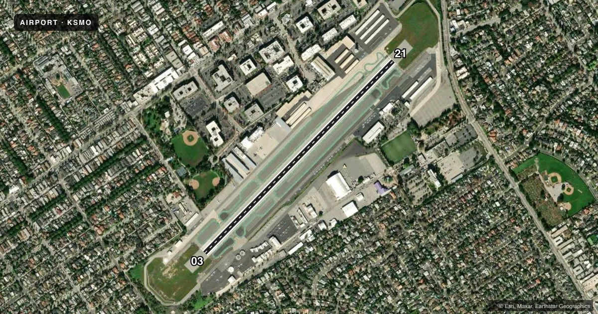
Runways & pattern
Full pagePattern entry · RWY 03
RIGHT TRAFFICRunway end performance
| End | TORA | TODA | ASDA | LDA | VGSI | Approach lights | Obstruction |
|---|---|---|---|---|---|---|---|
| 03 | 3,500' | 3,500' | 3,500' | 3,500' | PAPI 4-box left(3.42°) | — | — |
| 21 | 3,500' | 3,500' | 3,500' | 3,500' | PAPI 4-box left(3.5°) | — | — |
Declared distances in feet. TORA = takeoff run available, TODA = takeoff distance, ASDA = accelerate-stop, LDA = landing distance.
Airport sketch
Runways drawn to scale from FAA survey coordinates, rendered over satellite imagery. Not for navigation.
Approaches & charts
Services on the field
Fuel grades, oxygen, maintenance, ramp storage and lighting — as declared to the FAA by the airport operator.
Fuel & services
- Fuel
- 100LLAUL94
- Oxygen (bottled)
- High pressure
- Oxygen (bulk)
- High pressure
- Airframe repair
- Major
- Power plant repair
- Major
- Other services
- AVNCS,CHTR,INSTR,RNTL,SALES
Ramp & ground
- Transient storage
- Tie-down
- Landing fee
- Yes
- Customs
- Not available
- Lighting schedule
- SEE RMK
- Beacon schedule
- SS-SR
- Beacon
- White / Green (civil land)(WG)
- Wind indicator
- Lighted
- Segmented circle
- Yes
Fuel & FBOs
Cheapest 100LL and Jet A on the field and nearby. Always confirm with the FBO before taxi.
Airport notes
Surface conditions, obstructions, local procedures, lighting outages and other notes published with each FAA cycle.
General notes
- HEL FLT TRNG OPN PROHIBITED; HEL OPNS APCH ARPT BDRY AT MIDFIELD AT OR ABOVE 900 FT MSL.
- INTXN DEPS AND FRMN LNDGS/DEPS PROHIBITED.
- RWY 03/21 DEP END APPROX 1000 FT FM RESIDENTIAL HOMES. EXTENDED HIGH POWER SETTINGS ON RUN-UP OR DEP NEGATIVELY IMPACT THE COMMUNITY.
- PPR RQRD FOR DW ACFT IN EXCESS OF 60000 LBS CRTFYD MAX LDG WT, CTC AMGR 310-458-8692.
- NO TOUCH/GO, STOP/GO, OR LOW APCH PERMITTED ON SAT, SUN, HOLS; WEEKDAYS SS-0700.
- VFR DEPS RWY 21 TURN LEFT 10 DEGS OVER SMO VOR THEN TURN RIGHT 225 DEGS
- IF DEP NORTH, NO RIGHT TURNS BFR RCHG SHORELINE. RWY 03 DEP NO TURNS PRIOR TO 405 FREEWAY LCTD 1 MI EAST.
- ENG MAINT RUN-UP: JETS AND TURBOPROPS NORTH SIDE, WI 300 FT EAST OF TWY A4. PISTON SNGLS AND TWINS ON SOUTH SIDE, WI 300 FT EAST OF TWY B4. 0900-1700 ONLY.
- CONS NOISE ORDINANCE IN EFCT CTC NOISE OFFICE FOR PROCS (310) 458-8692.
- NOISE LMTS ALL ACFT: PURE JET AND STAGE II (WITH/WITHOUT HUSHKITS) PROHIBITED. MAX NOISE LIMIT 95.0 DBA SNGL EVENT NOISE EXPOSURE LEVEL (SENEL) RCRDD 2200 FT EXTDD CNTRLN.
- PPR EX-MIL ACFT CTC ARPT MGR (310) 458-8692.
- CURFEW: NO ENG STARTS, APU, OR TKOFS EXC PPR LIFEGUARD FLTS 2300-0700 MON-FRI AND 2300-0800 WKENDS.
- TURBINE ACFT & ACFT OVER 12,000 LBS PROHIBITED ON SOUTH SIDE TSNT PKNG.
- IFR JETS & TURBOPROPS CTC GND PRIOR TO ENG START.
- PURE JET AND STAGE II (WITH/WITHOUT HUSH KITS) PROHIBITED.
- TSNT PRKG SOUTH SIDE, NEXT TO BCN.
- THE PAVED AREAS PRECDG THE RWY 3-21 THRS ARE NOT AVBL FOR LDG, TKOF, OR TAXI OPS. THE PAVED AREAS ARE NOW BLAST PADS CREATED FROM THE THRS' RELOCATION AND RWY LENGTH REDUCTION IN DECEMBER 2017.
- ACFT MUST NOW EXIT THE RWY AT DSGND CONNECTOR TWYS. THE CONS RWY EXIT SYS IS NO LONGER AVBL.
- FOR CD WHEN ATCT CLSD CTC SOCAL APCH AT 800-448-3724.
Lighting notes
- WHEN ATCT CLSD ACTVT REIL RWY 21; MIRL RWY 03/21 - CTAF.
Fuel notes
- 100LL100LL FULL SVC ONLY.
- UL94UL94 AVBL AT SELF-SERVE ISLAND.
Other notes
- TPA: 1200' AGL SINGLE-ENG; 1700' AGL TWIN-ENG.
- MANAGERSTELIOS.MAKRIDES@SANTAMONICA.GOV
VFR map & nearby airports
VFR sectional. Tap any ICAO chip to open that airport.
Key facts · KSMO
Answer card- ICAO
- KSMO
- Name
- SANTA MONICA MUNI
- Location
- SANTA MONICA, CALIFORNIA
- Elevation
- 169.8 ft MSL
- Traffic pattern altitude
- 1,169.8 ft MSL (1,000 AGL)
- Control tower
- Towered · 0700-2100
- Total runways
- 1
- Longest runway
- 03/21 · 3,500 ft
- Published ILS approaches
- 0
- Published frequencies
- 17
- Magnetic variation
- 12°
- Current flight rules
- VFR
- Current wind
- 000° at 0 kt
- Favored runway now
- –
Santa Monica Muni sits in Santa Monica, California. Field elevation is 169.8 ft MSL. The airport has one runway, 03/21, which is 3,500 ft long. The tower is open daily from 0700 to 2100. No ILS approaches are published here, so plan with that in mind if the marine layer is in play.
The published pattern altitude is not listed. Use the standard 1,000 ft AGL pattern unless the current FAA Chart Supplement says otherwise. That puts you at about 1,170 ft MSL for light piston traffic. SoCal Approach handles the airspace around the field.
Ascension Group Partners is on the field. They carry UL94. Atlantic Aviation is also on the field. They carry AVGAS 100LL and JET A. 100LL is full service only. If you are arriving in a turbine aircraft or anything over 12,000 lb, note the south side transient parking restriction. IFR jets and turboprops must contact ground before engine start.
There are a few local items a first-time pilot should brief. Runway 03 departures cannot turn before the 405 Freeway. If departing north, no right turns before reaching the shoreline. Helicopter training is prohibited. Helicopter traffic must approach the airport boundary at midfield at or above 900 ft MSL. The paved areas before the runway thresholds are blast pads now, so they are not available for landing, takeoff, or taxi.