METAR & TAF KTOA
Current METAR
Observed 07:55Z
KTOA 270755Z AUTO 00000KT 10SM CLR 20/17 A2993 RMK AO2 T02050168 402740198 $
- Wind
- 000° @ 0 kt
- Visibility
- 10 SM
- Temp / Dew
- 20°C / 17°C
- Altimeter
- 29.93 inHg
- Clouds
- CLR
- Density alt
- 716 ft
- Ceiling
- Unlimited
- Rules
- VFR
Airport info & contacts
Manager on record, flight service, ARTCC, attendance schedule and pattern altitude — published by the FAA and refreshed every 28 days.
Location
- From city
- 3 NM SW
- VFR sectional
- LOS ANGELES
- ARTCC
- ZLA · LOS ANGELES
- NOTAM facility
- TOA (NOTAM-D)
Airport manager
- Name
- RAFAEL HERRERA
- Phone
- 310-784-7914
- Address
- CITY OF TORRANCE, 3301 AIRPORT DRIVE, TORRANCE CA 90505
Flight service · Hours
- FSS HHR
- HAWTHORNE1-800-WX-BRIEF
- Attendance
- 0600-2200
Frequencies
Tap any row to copy the frequency to your clipboard.
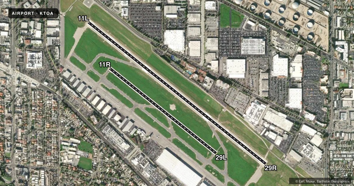
Runways & pattern
Full pagePattern entry · RWY 11L
LEFT TRAFFIC| Runway | Heading (°M) | Length | Surface | Traffic |
|---|---|---|---|---|
| 11L/29R | 114° / 294° | 5,001 ft | ASPH-CONC | 29R R |
| 11R/29L | 114° / 294° | 3,000 ft | ASPH-CONC | 11R R |
Runway end performance
| End | TORA | TODA | ASDA | LDA | VGSI | Approach lights | Obstruction |
|---|---|---|---|---|---|---|---|
| 11L | — | — | — | — | VASI 2-box left(3.5°) | — | 35', trees, 690' from thr, 0' R of cntrln, slope 14 |
| 29R | — | — | — | — | VASI 4-box left(4°) | MALSR | 22', bldg, 475' from thr, 530' R of cntrln, slope 12 |
| 29L | — | — | — | — | VASI 2-box left(4°) | — | 26', bldg, 1400' from thr, 100' R of cntrln, slope 46 |
Declared distances in feet. TORA = takeoff run available, TODA = takeoff distance, ASDA = accelerate-stop, LDA = landing distance.
Airport sketch
Runways drawn to scale from FAA survey coordinates, rendered over satellite imagery. Not for navigation.
Approaches & charts
ILS · 1
Services on the field
Fuel grades, oxygen, maintenance, ramp storage and lighting — as declared to the FAA by the airport operator.
Fuel & services
- Fuel
- 100LL
- Oxygen (bottled)
- HIGH/LOW
- Oxygen (bulk)
- HIGH/LOW
- Airframe repair
- Major
- Power plant repair
- Major
- Other services
- AVNCS,CHTR,INSTR,RNTL,SALES
Ramp & ground
- Transient storage
- Tie-down
- Landing fee
- Yes
- Customs
- Not available
- Lighting schedule
- SEE RMK
- Beacon schedule
- SS-SR
- Beacon
- White / Green (civil land)(WG)
- Wind indicator
- Lighted
- Segmented circle
- Yes
Fuel & FBOs
Cheapest 100LL and Jet A on the field and nearby. Always confirm with the FBO before taxi.
Airport notes
Surface conditions, obstructions, local procedures, lighting outages and other notes published with each FAA cycle.
General notes
- NO MULTI-ENGINE SIMULATED ENGINE-OUT PROCS AUTH IN TFC PAT. RY 11R/29L CLSD 2000-0700.
- NOISE SENSITIVE AREA ALL QUADS. FOR NOISE ABATEMENT PROCS INFO CTC ARPT NOISE ABATEMENT (310) 784-7950. CERTAIN TBJT ACFT PERMLY EXCLDD.
- AT TWYS HOTEL & CHARLIE OBS TWY HOLD LINES. ALL ACFT MUST HOLD BTN THE SET OF HOLD BARS FOR THE APCH ZONE FOR RWY 11R/29L.
- BE ALERT TO PSNL & EQPT OPRG NEAR ALL RWYS AND TWYS.
- NUMEROUS FLOCKS OF BIRDS ON AND INVOF ARPT.
- FOR CD WHEN ATCT CLSD CTC SOCAL APCH AT 800-448-3724.
- LNDG FAC IS FQTLY USED FOR MED AMBULANCE PURPOSES.
- TSNT PRKG LCTD AT THE BASE OF THE ATCT. GREEN BOX WHITE T FOR SMALL ACFT; BLUE BOX WHITE T FOR JETS.
- NO TGL OR STOP & GO OPS PMTD. NO LOW APCH OR FULL STOP TAXI-BACK PMTD BTN 1800-1000 MON-FRI. NO LOW APCH OR FULL STOP TAXI-BACK PMTD SAT, SUN BTN FRI 1800 & MON 1000, OR HOLS. ARPT CLSD TO DEP 2200-0700 WKDAYS & 2200-0800 WKENDS & HOLS.
Lighting notes
- WHEN ATCT CLSD ACTVT MALSR RY 29R - CTAF; MIRL RY 11L/29R SS-SR; MIRL RY 11R/29L 0600-2000; ACTVT HELIPAD PERIMETER LGTS - 24 HRS - CTAF. VASI RWY 29L OPER CONSLY.
Fuel notes
- 100LLFUEL AVBL 0700-2000.
Runway surface & condition
- H1YELLOW PERIMETER LGTS.
Approach & departure obstructions
- 29R+9 FT MALSR BLDG 190 FT FROM E OR 440 FT RIGHT.
- 29LUNUSBL BYD 2 DEG RIGHT & 9 DEG LEFT OF RWY CNTRLN.
- 11LRWY 11L APCH RATIO TO DSPLCD THR 35:1;
- 29RAPCH RATIO 46:1 TO DSPLCD THLD.
Other notes
- FOR LDG FEE SKED, CTC ARPT OR CHECK ARPT WEBSITE. MIL, PUB SAFETY, AND MED OPS SHALL BE EXEMPT FROM LDG FEES.
- H1FATO AND TLOF PAVED.
VFR map & nearby airports
VFR sectional. Tap any ICAO chip to open that airport.
Key facts · KTOA
Answer card- ICAO
- KTOA
- Name
- ZAMPERINI FLD
- Location
- TORRANCE, CALIFORNIA
- Elevation
- 103.2 ft MSL
- Traffic pattern altitude
- 1,103.2 ft MSL (1,000 AGL)
- Control tower
- Towered · 0700-2000
- Total runways
- 2
- Longest runway
- 11L/29R · 5,001 ft
- Published ILS approaches
- 1
- Published frequencies
- 15
- Magnetic variation
- 14°
- Current flight rules
- VFR
- Current wind
- 000° at 0 kt
- Favored runway now
- –
Zamperini Field sits in Torrance, California. Field elevation is 103.2 ft MSL. The airport has 2 runways. The longest is 11L/29R at 5,001 ft. The tower is open 0700 to 2000. SoCal Approach handles clearance delivery when the tower is closed. One ILS is published for runway 29R.
Pattern altitude is not published. Use the standard 1,000 ft AGL for light piston operations unless ATC or the current FAA Chart Supplement says otherwise. That puts the traffic pattern at about 1,103 ft MSL based on the field elevation. The airport sits in a noise-sensitive area in all quadrants. Check the current FAA Chart Supplement for any published noise or curfew restrictions before flying into the field. The field also has bird activity in and around the airport. Keep your scan active on arrival and departure.
Three on-field FBOs are listed. Great American Aviation, Torrance Flite Park and South Bay Aviation all carry 100LL. Runway 11R/29L is closed from 2000 to 0700. No touch-and-go or stop-and-go operations are permitted. Airport departures are also restricted overnight on weekdays and weekends. Taxi carefully at Hotel and Charlie. Hold between the set of hold bars for the runway 11R/29L approach zone. If you are new to KTOA, plan for busy local traffic, noise sensitivity and the published runway use limits before you roll.