METAR & TAF KFUL
Current METAR
Observed 06:53Z
KFUL 270653Z AUTO 17003KT 10SM CLR 22/19 A2993 RMK AO2 SLP134 T02220189 $
- Wind
- 170° @ 3 kt
- Visibility
- 10 SM
- Temp / Dew
- 22°C / 19°C
- Altimeter
- 29.93 inHg
- Clouds
- CLR
- Density alt
- 947 ft
- Ceiling
- Unlimited
- Rules
- VFR
Airport info & contacts
Manager on record, flight service, ARTCC, attendance schedule and pattern altitude — published by the FAA and refreshed every 28 days.
Location
- From city
- 3 NM W
- VFR sectional
- LOS ANGELES
- Pattern altitude
- 1,004 ft AGL · 1,100 ft MSL
- ARTCC
- ZLA · LOS ANGELES
- NOTAM facility
- FUL (NOTAM-D)
Airport manager
- Name
- BRENDAN O'REILLY
- Phone
- 714-738-6323
- Address
- 4011 W COMMONWEALTH AVE, FULLERTON CA 92833-2537
Flight service · Hours
- FSS RAL
- RIVERSIDE1-800-WX-BRIEF
- Attendance
- 0700-2100
Frequencies
Tap any row to copy the frequency to your clipboard.
Runways & pattern
Full pagePattern entry · RWY 24
RIGHT TRAFFICRunway end performance
| End | TORA | TODA | ASDA | LDA | VGSI | Approach lights | Obstruction |
|---|---|---|---|---|---|---|---|
| 06 | — | — | — | — | PAPI 2-box left(4°) | — | — |
| 24 | — | — | — | — | PAPI 4-box left(4°) | — | 23', rr, 225' from thr, 80' R of cntrln, slope 1 |
Declared distances in feet. TORA = takeoff run available, TODA = takeoff distance, ASDA = accelerate-stop, LDA = landing distance.
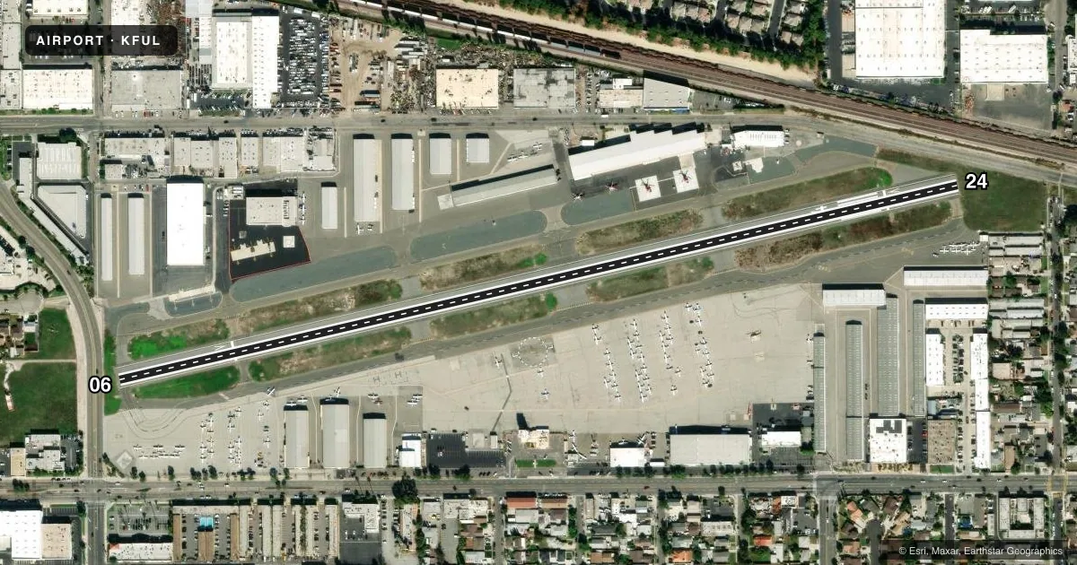
Airport sketch
Runways drawn to scale from FAA survey coordinates, rendered over satellite imagery. Not for navigation.
Approaches & charts
ILS · 1
Services on the field
Fuel grades, oxygen, maintenance, ramp storage and lighting — as declared to the FAA by the airport operator.
Fuel & services
- Fuel
- 100LLA
- Oxygen (bottled)
- High pressure
- Oxygen (bulk)
- High pressure
- Airframe repair
- Major
- Power plant repair
- Major
- Other services
- AMB,CHTR,INSTR,RNTL,SALES
Ramp & ground
- Transient storage
- Tie-down
- Landing fee
- No fee published
- Customs
- Not available
- Lighting schedule
- SEE RMK
- Beacon schedule
- SS-SR
- Beacon
- White / Green (civil land)(WG)
- Wind indicator
- Lighted
- Segmented circle
- Yes
Fuel & FBOs
Cheapest 100LL and Jet A on the field and nearby. Always confirm with the FBO before taxi.
Airport notes
Surface conditions, obstructions, local procedures, lighting outages and other notes published with each FAA cycle.
General notes
- ARPT HAS NOISE ABATEMENT PROCEDURES CTC AMGR (714) 738-6323.
- RY 06 CALM WIND RY.
- PORTIONS OF TWY A BTN INTERSECTION F & WEST END NOT VSBL FM ATCT.
- FOR NOISE ABATEMENT RY 06 PREFERRED FOR TKOF; FOLLOW RR TRACKS TO EAST WITH NO TURNS BLO 1000 FT AGL. RY 24 DEP CLIMB TO 700 FT AGL PRIOR TO TURNS.
- (84) SEGMENTED CIRCLE LGTD.
- LGTD 750 FT TOWER 1.75 MILES WEST OF ARPT ON HEADING OF 285 DEG FROM ARPT.
- FOR CD WHEN ATCT CLSD CTC SOCAL APCH AT 800-448-3724.
- PORTIONS OF TWY A ADJACENT TO THE APCH END OF RWY 24 NOT VSBL FM ATCT.
Lighting notes
- WHEN ATCT CLSD ACTVT REIL RWY 06 & 24; PAPI RWY 06 & 24; MIRL RWY 06/24; TWY LGTS - CTAF.
Approach & departure obstructions
- 06+8 FT FENCE AT 55 FT & +15 FT STREET AT 65 FT FM APCH END RY 06.
- 24+8 FT FENCE AT 15 FT & +15 FT STREET AT 17 FT; POLE & RR AT 100 FT FM APCH END RY 24.
- 06APCH RATIO 14:1 TO DSPLCD THR.
- 24APCH RATIO 15:1 TO DSPLCD THR.
Other notes
- THIS AIRPORT HAS BEEN SURVEYED BY THE NATIONAL GEODETIC SURVEY.
- MANAGERBRENDAN.OREILLY@CITYOFFULLERTON.COM
VFR map & nearby airports
VFR sectional. Tap any ICAO chip to open that airport.
Key facts · KFUL
Answer card- ICAO
- KFUL
- Name
- FULLERTON MUNI
- Location
- FULLERTON, CALIFORNIA
- Elevation
- 96 ft MSL
- Traffic pattern altitude
- 1,100 ft MSL (1,004 AGL)
- Control tower
- Towered · 0700-2100
- Total runways
- 1
- Longest runway
- 06/24 · 3,121 ft
- Published ILS approaches
- 1
- Published frequencies
- 7
- Magnetic variation
- 14°
- Current flight rules
- VFR
- Current wind
- 170° at 3 kt
- Favored runway now
- RWY 24
Fullerton Muni sits in Fullerton, California. Field elevation is 96 ft MSL. The airport has one runway, 06/24 and it is 3,121 ft long. The tower is open from 0700 to 2100. When the tower is closed, use the published lighting procedures and contact SoCal Approach for clearance delivery. The field has one ILS approach. It serves runway 24.
Pattern altitude is 1,004 ft AGL, which is 1,100 ft MSL. That matters here because the airport sits in a busy Southern California traffic flow with close-in noise concerns. For noise abatement, runway 06 is preferred for takeoff. The published departure path calls for following the railroad tracks east with no turns below 1,000 ft AGL. For runway 24 departures, climb to 700 ft AGL before turning. There is also a lighted tower about 1.75 miles west of the airport on a 285 degree bearing from the field. Taxiway A has some areas that are not visible from the tower. Keep your head on a swivel on the ground.
General Aviation Company is on the field. It carries 100LL, Jet A and Jet A Prist. The runway ends have displaced threshold-related obstacle notes. Brief your landing and departure distances carefully before you go.