METAR & TAF KCNO
Current METAR
Observed 05:53Z
KCNO 270553Z AUTO 29007KT 8SM CLR 24/17 A2995 RMK AO2 SLP135 T02390172 10361 20239 51019 $
- Wind
- 290° @ 7 kt
- Visibility
- 8 SM
- Temp / Dew
- 24°C / 17°C
- Altimeter
- 29.95 inHg
- Clouds
- CLR
- Density alt
- 1,849 ft
- Ceiling
- Unlimited
- Rules
- VFR
Airport info & contacts
Manager on record, flight service, ARTCC, attendance schedule and pattern altitude — published by the FAA and refreshed every 28 days.
Location
- From city
- 3 NM SE
- VFR sectional
- LOS ANGELES
- Pattern altitude
- 750 ft AGL · 1,400 ft MSL
- ARTCC
- ZLA · LOS ANGELES
- NOTAM facility
- CNO (NOTAM-D)
Airport manager
- Name
- GREGORY ZARCO
- Phone
- 909-465-5202
- Address
- 7000 MERRILL AVE, BOX 1, CHINO CA 91710-0831
Flight service · Hours
- FSS RAL
- RIVERSIDE1-800-WX-BRIEF
- Attendance
- ALL
Frequencies
Tap any row to copy the frequency to your clipboard.
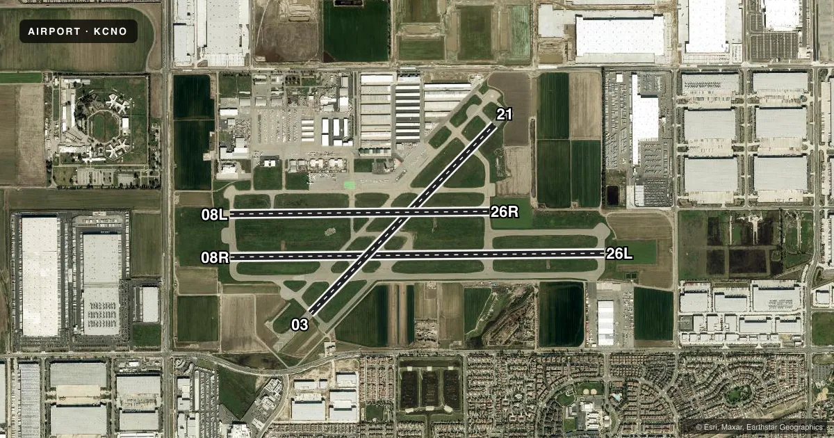
Runways & pattern
Full pagePattern entry · RWY 26L
LEFT TRAFFIC| Runway | Heading (°M) | Length | Surface | Traffic |
|---|---|---|---|---|
| 08R/26LFavored | 75° / 255° | 7,000 ft | ASPH | 08R R |
| 03/21 | 30° / 210° | 4,919 ft | ASPH | 03 R |
| 08L/26R | 75° / 255° | 4,858 ft | ASPH | 08L R |
Runway end performance
| End | TORA | TODA | ASDA | LDA | VGSI | Approach lights | Obstruction |
|---|---|---|---|---|---|---|---|
| 08R | — | — | — | — | PAPI 4-box left(3°) | — | — |
| 26L | — | — | — | — | PAPI 4-box left(3°) | — | 55', trees, 1320' from thr, 75' R of cntrln, slope 20 |
| 03 | — | — | — | — | PAPI 4-box left(3°) | — | — |
| 21 | — | — | — | — | PAPI 4-box left(3°) | — | — |
| 08L | — | — | — | — | PAPI 4-box left(3°) | — | 65', trees, 1571' from thr, 140' R of cntrln, slope 21 |
| 26R | — | — | — | — | PAPI 4-box left(3°) | — | 60', trees, 2150' from thr, 250' R of cntrln, slope 32 |
Declared distances in feet. TORA = takeoff run available, TODA = takeoff distance, ASDA = accelerate-stop, LDA = landing distance.
Airport sketch
Runways drawn to scale from FAA survey coordinates, rendered over satellite imagery. Not for navigation.
Approaches & charts
ILS · 1
Services on the field
Fuel grades, oxygen, maintenance, ramp storage and lighting — as declared to the FAA by the airport operator.
Fuel & services
- Fuel
- 100LLA
- Oxygen (bottled)
- Not available
- Oxygen (bulk)
- Low pressure
- Airframe repair
- Major
- Power plant repair
- Major
- Other services
- AFRT,AMB,AVNCS,CARGO,CHTR,INSTR,RNTL,SALES
Ramp & ground
- Transient storage
- Tie-down
- Hangar
- Landing fee
- No fee published
- Customs
- Not available
- Lighting schedule
- SEE RMK
- Beacon schedule
- SS-SR
- Beacon
- White / Green (civil land)(WG)
- Wind indicator
- Lighted
- Segmented circle
- No
Fuel & FBOs
Cheapest 100LL and Jet A on the field and nearby. Always confirm with the FBO before taxi.
Airport notes
Surface conditions, obstructions, local procedures, lighting outages and other notes published with each FAA cycle.
General notes
- RADIO CONTROLLED AIRCRAFT ACTIVITY BELOW 400 FT AGL 2.5 NM SOUTH OF AIRPORT
- BIRDS AND WILDLIFE ON AND INVOF ARPT.
- FOR CD WHEN ATCT CLSD CTC SOCAL APCH AT 800-448-3724.
Lighting notes
- WHEN ATCT CLSD MIRL RY 03/21, HIRL RY 08L/26R, MIRL 08R/26L ARE TURNED ON. PAPI RYS 26R, 08R, 26L, 03, 21 AND REIL RYS 03 & 21 OPER CONTINUOUSLY.
Fuel notes
- 100LLSELF-SERVICE FUEL AVBL 24 HRS.
Other notes
- TWIN ENGINE TPA 1350 FT AGL.
VFR map & nearby airports
VFR sectional. Tap any ICAO chip to open that airport.
Key facts · KCNO
Answer card- ICAO
- KCNO
- Name
- CHINO
- Location
- CHINO, CALIFORNIA
- Elevation
- 650 ft MSL
- Traffic pattern altitude
- 1,400 ft MSL (750 AGL)
- Control tower
- Towered · 0700-2100
- Total runways
- 3
- Longest runway
- 08R/26L · 7,000 ft
- Published ILS approaches
- 1
- Published frequencies
- 14
- Magnetic variation
- 14°
- Current flight rules
- VFR
- Current wind
- 290° at 7 kt
- Favored runway now
- RWY 26L
Chino Airport sits in Chino, California. Field elevation is 650 ft MSL. The airport has three asphalt runways. The longest is 08R/26L at 7,000 ft. The other runways are 03/21 at 4,919 ft. Runway 08L/26R is 4,858 ft. The tower is open daily from 0700 to 2100. One ILS is published for runway 26R.
Pattern altitude is 750 ft AGL. That is 1,400 ft MSL. Twin engine traffic uses a higher pattern at 1,350 ft AGL. The airport sits under SoCal Class C procedures. Expect busy radio work and standard sequencing. Birds and wildlife are reported on and near the airport. Radio controlled aircraft activity is also reported below 400 ft AGL about 2.5 NM south of the field.
Three on-field FBOs are listed. Threshold Aviation, Chino Fuel Services and Flying Tigers Aviation all carry 100LL, Jet A and Jet A Prist. Self-serve 100LL is available 24 hours. When the tower is closed, runway lighting remains available on all three runways. PAPI is published on 26R, 08R, 26L, 03 and 21. REIL is published on 03 and 21. If you need clearance delivery after tower hours, contact SoCal Approach. A first-time arrival should brief the runway layout carefully. Stay sharp for local traffic flow.