METAR & TAF KRIR
KRIR does not publish a METAR.
Showing the nearest reporting station: KRAL (RIVERSIDE) · 2.8 NM away. Conditions at KRIR may differ.
METAR · KRAL
Observed 08:53Z
KRAL 270853Z AUTO 28003KT 10SM CLR 23/16 A2994 RMK AO2 SLP121 T02330161 58001
- Wind
- 280° @ 3 kt
- Visibility
- 10 SM
- Temp / Dew
- 23°C / 16°C
- Altimeter
- 29.94 inHg
- Clouds
- CLR
- Density alt
- 1,886 ft
- Ceiling
- Unlimited
- Rules
- VFR
Airport info & contacts
Manager on record, flight service, ARTCC, attendance schedule and pattern altitude — published by the FAA and refreshed every 28 days.
Location
- From city
- 3 NM NW
- VFR sectional
- LOS ANGELES
- Pattern altitude
- 700 ft AGL · 1,467 ft MSL
- ARTCC
- ZLA · LOS ANGELES
- NOTAM facility
- RAL (NOTAM-D)
Airport manager
- Name
- COLEMAN FAIT
- Phone
- 951-683-2309
- Address
- 4130 MENNES AVE, RIVERSIDE CA 92509
Flight service · Hours
- FSS RAL
- RIVERSIDE1-800-WX-BRIEF
- Attendance
- MON-FRI · 0830-1630
Frequencies
Tap any row to copy the frequency to your clipboard.
Runways & pattern
Full pagePattern entry · RWY 24
LEFT TRAFFICRunway end performance
| End | TORA | TODA | ASDA | LDA | VGSI | Approach lights | Obstruction |
|---|---|---|---|---|---|---|---|
| 06 | — | — | — | — | — | — | 25', trees, 310' from thr, 0' R of cntrln, slope 4 |
Declared distances in feet. TORA = takeoff run available, TODA = takeoff distance, ASDA = accelerate-stop, LDA = landing distance.
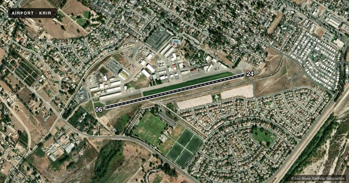
Airport sketch
Runways drawn to scale from FAA survey coordinates, rendered over satellite imagery. Not for navigation.
Approaches & charts
Services on the field
Fuel grades, oxygen, maintenance, ramp storage and lighting — as declared to the FAA by the airport operator.
Fuel & services
- Fuel
- 100LL
- Oxygen (bottled)
- Not available
- Oxygen (bulk)
- Not available
- Airframe repair
- Major
- Power plant repair
- Major
- Other services
- INSTR
Ramp & ground
- Transient storage
- Tie-down
- Landing fee
- No fee published
- Customs
- Not available
- Lighting schedule
- SEE RMK
- Wind indicator
- Lighted
- Segmented circle
- No
Fuel & FBOs
Cheapest 100LL and Jet A on the field and nearby. Always confirm with the FBO before taxi.
Airport notes
Surface conditions, obstructions, local procedures, lighting outages and other notes published with each FAA cycle.
General notes
- MTN 1340 FT MSL 3/4 MILE SE OF ARPT +20 FT CROSS ON TOP.
- DEPARTURES TO THE SOUTH CTC RIVERSIDE ATCT.
- RY 24 AFT TKOF TURN LEFT 10 DEG; STAY NORTH OF RIVERBED.
- RY 24 CALM WIND RY.
- FOR CD CTC SOCAL APCH AT 800-448-3724.
Lighting notes
- DUSK-DAWN. ACTVT MIRL RY 06/24 - CTAF.
Runway surface & condition
- 06/24RWY 06/24 NSTD MIRL GTR THAN 10 FT FROM RWY EDGE.
Other notes
- PREDATES 1958 FA ACT.
- NIGHT TPA 1000 FT AGL AROUND THE MOUNTAIN.
VFR map & nearby airports
VFR sectional. Tap any ICAO chip to open that airport.
Key facts · KRIR
Answer card- ICAO
- KRIR
- Name
- FLABOB
- Location
- RIVERSIDE/RUBIDOUX/, CALIFORNIA
- Elevation
- 767 ft MSL
- Traffic pattern altitude
- 1,467 ft MSL (700 AGL)
- Control tower
- Non-towered (use CTAF)
- Total runways
- 1
- Longest runway
- 06/24 · 3,190 ft
- Published ILS approaches
- 0
- Published frequencies
- 6
- Magnetic variation
- 13°
- Current flight rules
- VFR
- Current wind
- 280° at 3 kt
- Favored runway now
- RWY 24
Flabob Airport is in Riverside/Rubidoux, California. The field elevation is 767 ft MSL. It has one runway, 06/24, at 3,190 ft. There is no control tower. No ILS approaches are published. The pattern altitude is 700 ft AGL. That is 1,467 ft MSL.
Flabob Airport is on the field and carries AVGAS 100LL. If you need fuel or ramp details, call the airport directly at (951) 683-2309 before you go. The airport predates the 1958 Federal Aviation Act. That tells you this is a long-established field with some older operating quirks. Runway 24 is the calm wind runway. After takeoff from runway 24, turn left 10 degrees and stay north of the riverbed. That matters on departure.
The runway lights on 06/24 are medium intensity lights. They are activated from dusk to dawn by the CTAF. The night pattern altitude is 1,000 ft AGL around the mountain. There is a mountain 1,340 ft MSL about three quarters of a mile southeast of the airport. It has 20 ft of cross obstruction on top. Departures to the south must contact Riverside air traffic control tower. For clearance delivery, contact SoCal Approach. This is a good airport to brief carefully before arrival, especially if you are new to the area.