METAR & TAF KREI
KREI does not publish a METAR.
Showing the nearest reporting station: KSBD (SAN BERNARDINO INTL) · 4.4 NM away. Conditions at KREI may differ.
METAR · KSBD
Observed 07:20Z
KSBD 270720Z AUTO 26005KT 10SM CLR 26/15 A2996 RMK AO2 T02570147
- Wind
- 260° @ 5 kt
- Visibility
- 10 SM
- Temp / Dew
- 26°C / 15°C
- Altimeter
- 29.96 inHg
- Clouds
- CLR
- Density alt
- 3,223 ft
- Ceiling
- Unlimited
- Rules
- VFR
Airport info & contacts
Manager on record, flight service, ARTCC, attendance schedule and pattern altitude — published by the FAA and refreshed every 28 days.
Location
- From city
- 2 NM NE
- VFR sectional
- LOS ANGELES
- Pattern altitude
- 929 ft AGL · 2,503 ft MSL
- ARTCC
- ZLA · LOS ANGELES
- NOTAM facility
- RAL (NOTAM-D)
Airport manager
- Name
- TED RICHARDSON
- Phone
- 909-557-8520
- Address
- 1745 SESSUMS DRIVE, REDLANDS CA 92373
Flight service · Hours
- FSS RAL
- RIVERSIDE1-800-WX-BRIEF
- Attendance
- 0800-1700
Frequencies
Tap any row to copy the frequency to your clipboard.
Runways & pattern
Full pagePattern entry · RWY 26
RIGHT TRAFFICRunway end performance
| End | TORA | TODA | ASDA | LDA | VGSI | Approach lights | Obstruction |
|---|---|---|---|---|---|---|---|
| 08 | — | — | — | — | PAPI 2-box left(3°) | — | 4', fence, 300' from thr, 125' R of cntrln, slope 25 |
| 26 | — | — | — | — | — | — | 60', trees, 1500' from thr, 120' R of cntrln, slope 22 |
Declared distances in feet. TORA = takeoff run available, TODA = takeoff distance, ASDA = accelerate-stop, LDA = landing distance.
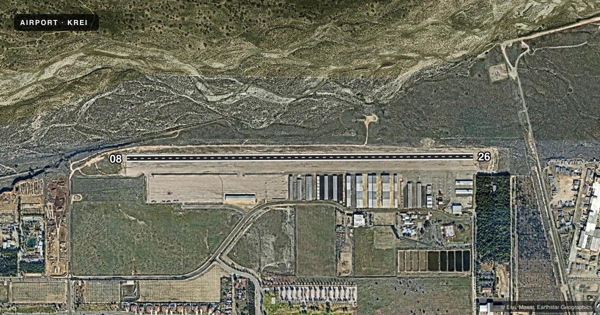
Airport sketch
Runways drawn to scale from FAA survey coordinates, rendered over satellite imagery. Not for navigation.
Approaches & charts
Services on the field
Fuel grades, oxygen, maintenance, ramp storage and lighting — as declared to the FAA by the airport operator.
Fuel & services
- Fuel
- 100LL
- Oxygen (bottled)
- Not available
- Oxygen (bulk)
- HIGH/LOW
- Airframe repair
- Major
- Power plant repair
- Major
- Other services
- AVNCS,CHTR,INSTR,RNTL,SALES
Ramp & ground
- Transient storage
- Tie-down
- Landing fee
- No fee published
- Customs
- Not available
- Lighting schedule
- SEE RMK
- Beacon schedule
- SS-SR
- Beacon
- White / Green (civil land)(WG)
- Wind indicator
- Lighted
- Segmented circle
- Yes
Fuel & FBOs
Cheapest 100LL and Jet A on the field and nearby. Always confirm with the FBO before taxi.
Airport notes
Surface conditions, obstructions, local procedures, lighting outages and other notes published with each FAA cycle.
General notes
- AVOID NOISE SENSITIVE AREAS S OF ARPT.
- AEROBATIC ACT NE OF ARPT FROM 3800 FT MSL TO 7800 FT MSL; SEE SPECIAL NOTICE - AEROBATIC OPERATIONS NORTHEAST OF REDLANDS, CA.
- COYOTES AND WATERFOWL ON AND INVOF ARPT.
- FOR CD CTC SOCAL APCH AT 800-448-3724.
- RMN VIGILANT TO SEE AND AVOID LRG AND HVY ACFT WI 5 NM OF REI AND ON SBD RWY 24 APCH WI 1.5 NM EAST THRU NORTH OF RWY; CTN WAKE TURB. ACTVLY MNT REI CTAF AND, IF POSS, SBD ON 119.45. OPR TRANSPONDER AND ADS-B OUT STRONGLY ENCOURAGED.
- TSNT HEL PRKG ON WEST RAMP ONLY. HEL NOSE FACING EAST OR WEST. CALL ARPT MGMT FOR PRKG DTLS AT 909-557-8520.
Lighting notes
- ACTVT REIL RWYS 08 & 26; PAPI RWY 08; MIRL RWY 08/26 - CTAF.
Fuel notes
- 100LLSELF SERVE 100LL FUEL AVBL 24-7.
Other notes
- TPA - 929 FOR FIXED WING ACFT, N SIDE OF RWY 08/26; 500 FOR HEL, S SIDE OF RWY 08/26.
- AUTOMATED UNICOM; 3 CLICKS FOR WX AND ADZY, 4 CLICKS FOR RADIO CHECK.
- MANAGERMAIN NO: 909-557-8520
VFR map & nearby airports
VFR sectional. Tap any ICAO chip to open that airport.
Key facts · KREI
Answer card- ICAO
- KREI
- Name
- REDLANDS MUNI
- Location
- REDLANDS, CALIFORNIA
- Elevation
- 1,574.4 ft MSL
- Traffic pattern altitude
- 2,503.4 ft MSL (929 AGL)
- Control tower
- Non-towered (use CTAF)
- Total runways
- 1
- Longest runway
- 08/26 · 4,504 ft
- Published ILS approaches
- 0
- Published frequencies
- 6
- Magnetic variation
- 14°
- Current flight rules
- VFR
- Current wind
- 260° at 5 kt
- Favored runway now
- RWY 26
Redlands Muni sits in Redlands, California at 1,574.4 ft MSL. The airport has one runway, 08/26, which is 4,504 ft long. There is no control tower. Pattern altitude for fixed wing aircraft is 929 ft AGL, which is 2,503.4 ft MSL. Helicopter pattern altitude is 500 ft on the south side of runway 08/26.
No ILS approaches are published here. The airport is worked by SoCal Approach for approach and departure services. Redlands Aviation is the on-field FBO. It carries 100LL. Self-serve 100LL is available 24 hours a day, 7 days a week.
This field has a few things a first-time pilot should plan for. There is aerobatic activity northeast of the airport from 3,800 ft MSL to 7,800 ft MSL. Large and heavy aircraft operate nearby. That includes traffic on the San Bernardino runway 24 approach. Wake turbulence is a real consideration. Transponder and ADS-B Out use is strongly encouraged. Noise sensitive areas lie south of the airport, so plan your pattern work with that in mind. Runway end identifier lights, medium intensity runway lights and a PAPI on runway 08 are published. Coyotes and waterfowl are also noted in the airport area.