METAR & TAF L26
L26 does not publish a METAR.
Showing the nearest reporting station: KVCV (SOUTHERN CALIFORNIA LOGISTICS) · 13.5 NM away. Conditions at L26 may differ.
METAR · KVCV
Observed 09:35Z
KVCV 260935Z AUTO 19005KT 10SM CLR 25/13 A3003 RMK AO2
- Wind
- 190° @ 5 kt
- Visibility
- 10 SM
- Temp / Dew
- 25°C / 13°C
- Altimeter
- 30.03 inHg
- Clouds
- CLR
- Density alt
- 5,267 ft
- Ceiling
- Unlimited
- Rules
- VFR
Airport info & contacts
Manager on record, flight service, ARTCC, attendance schedule and pattern altitude — published by the FAA and refreshed every 28 days.
Location
- From city
- 3 NM S
- VFR sectional
- LOS ANGELES
- ARTCC
- ZLA · LOS ANGELES
- NOTAM facility
- RAL (NOTAM-D)
Airport manager
- Name
- DEBBIE VESPY
- Phone
- (442) 243-4331
- Address
- 7070 SUMMIT VALLEY ROAD, HESPERIA CA 92345
Flight service · Hours
- FSS RAL
- RIVERSIDE1-800-WX-BRIEF
- Attendance
- Unattended
Frequencies
Tap any row to copy the frequency to your clipboard.
Runways & pattern
Full pagePattern entry · RWY 21
LEFT TRAFFICRunway end performance
| End | TORA | TODA | ASDA | LDA | VGSI | Approach lights | Obstruction |
|---|---|---|---|---|---|---|---|
| 03 | — | — | — | — | — | — | 7', tree, 340' from thr, 78' R of cntrln, slope 20 |
| 21 | — | — | — | — | — | — | 15', road, 200' from thr, 125' R of cntrln, slope 0 |
Declared distances in feet. TORA = takeoff run available, TODA = takeoff distance, ASDA = accelerate-stop, LDA = landing distance.
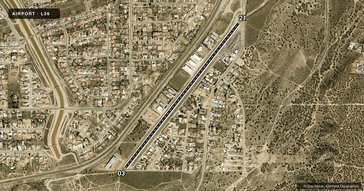
Airport sketch
Runways drawn to scale from FAA survey coordinates, rendered over satellite imagery. Not for navigation.
Approaches & charts
Services on the field
Fuel grades, oxygen, maintenance, ramp storage and lighting — as declared to the FAA by the airport operator.
Fuel & services
- Fuel
- 100LL
- Other services
- AMB
Ramp & ground
- Transient storage
- Tie-down
- Landing fee
- No fee published
- Customs
- Not available
- Lighting schedule
- SEE RMK
- Beacon schedule
- SS-SR
- Beacon
- White / Green (civil land)(WG)
- Wind indicator
- Lighted
- Segmented circle
- Yes
Fuel & FBOs
Cheapest 100LL and Jet A on the field and nearby. Always confirm with the FBO before taxi.
Airport notes
Surface conditions, obstructions, local procedures, lighting outages and other notes published with each FAA cycle.
General notes
- PUBLIC ROAD ACCESS TO RUNWAY AND TAXIWAY IN MULTIPLE LOCATIONS.
- SLIGHT UPHILL GRADE TO RY 21. PILOTS SHOULD BE AWARE OF RISING SURROUNDING TERRAIN TO THE SOUTH. RY 21 HAS A PERIMETER FENCE THAT SEPARATES RY 21 FROM ROAD.
- CALM WIND USE RY 21.
- FOR CD CTC JOSHUA APCH AT 661-277-3843.
Lighting notes
- DUSK-DAWN. ACTVT LIRL RY 03/21 - CTAF.
Approach & departure obstructions
- 03ROAD AT 30 FT FM THR.
- 21+6 FT FENCE 10 FT FM THLD & ROAD RUNS THRU PRIM SFC.
- 03APCH RATIO TO DSPLCD THR OVER +15 FT ROAD 200 FT FM DSPLCD THLD 145 FT RIGHT 13:1.
- 21APCH RATIO TO DSPLCD THR OVER +15 FT ROAD 500 FT FM DSPLCD THR 175 FT LEFT 33:1.
Other notes
- ESTABD PRIOR TO 5/15/59.
- 03/21SUBSTANTIAL CRACKS AND RAVELING.
VFR map & nearby airports
VFR sectional. Tap any ICAO chip to open that airport.
Key facts · L26
Answer card- ICAO
- L26
- Name
- HESPERIA
- Location
- HESPERIA, CALIFORNIA
- Elevation
- 3,390 ft MSL
- Traffic pattern altitude
- 4,390 ft MSL (1,000 AGL)
- Control tower
- Non-towered (use CTAF)
- Total runways
- 1
- Longest runway
- 03/21 · 3,910 ft
- Published ILS approaches
- 0
- Published frequencies
- 2
- Magnetic variation
- 14°
- Current flight rules
- VFR
- Current wind
- 190° at 5 kt
- Favored runway now
- RWY 21
Hesperia Airport sits in Hesperia, California at 3,390 ft MSL. It has one runway, 03/21, which is 3,910 ft long and paved. There is no control tower. CTAF and UNICOM are both 123.0. No ILS approaches are published here.
Pattern altitude is not published. For light piston traffic, use the standard 1,000 ft AGL unless current local guidance says otherwise. The airport uses runway lighting from dusk to dawn. Low intensity runway lights on 03/21 are activated via CTAF.
This field has no on-field FBOs listed, so verify services with the airport operator or by calling the field before arrival. Published remarks also matter here. Public roads cross the runway and taxiway in multiple spots. The runway surface has substantial cracks and raveling. Runway 21 has a slight uphill grade, with rising terrain to the south. Use runway 21 when winds are calm. Clearance delivery is handled through Joshua Approach at 661-277-3843.
The runway ends have close-in obstructions. That makes a stabilized approach important, especially with the field elevation and surrounding terrain. Check the current Chart Supplement before you go for any updates on local procedures or restrictions.