METAR & TAF KAPV
KAPV does not publish a METAR.
Showing the nearest reporting station: KVCV (SOUTHERN CALIFORNIA LOGISTICS) · 9.8 NM away. Conditions at KAPV may differ.
METAR · KVCV
Observed 09:35Z
KVCV 260935Z AUTO 19005KT 10SM CLR 25/13 A3003 RMK AO2
- Wind
- 190° @ 5 kt
- Visibility
- 10 SM
- Temp / Dew
- 25°C / 13°C
- Altimeter
- 30.03 inHg
- Clouds
- CLR
- Density alt
- 4,860 ft
- Ceiling
- Unlimited
- Rules
- VFR
Airport info & contacts
Manager on record, flight service, ARTCC, attendance schedule and pattern altitude — published by the FAA and refreshed every 28 days.
Location
- From city
- 3 NM N
- VFR sectional
- LOS ANGELES
- ARTCC
- ZLA · LOS ANGELES
- NOTAM facility
- RAL (NOTAM-D)
Airport manager
- Name
- TESS COOK
- Phone
- 909-327-8740
- Address
- 21600 CORWIN ROAD, APPLE VALLEY CA 92307
Flight service · Hours
- FSS RAL
- RIVERSIDE1-800-WX-BRIEF
- Attendance
- 0800-1700
Frequencies
Tap any row to copy the frequency to your clipboard.
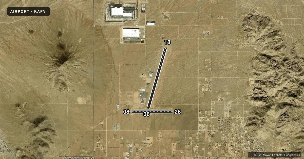
Runways & pattern
Full pagePattern entry · RWY 18
LEFT TRAFFIC| Runway | Heading (°M) | Length | Surface | Traffic |
|---|---|---|---|---|
| 18/36Favored | 182° / 2° | 6,498 ft | ASPH | 36 R |
| 08/26 | 76° / 256° | 4,100 ft | ASPH | 08 R |
Runway end performance
| End | TORA | TODA | ASDA | LDA | VGSI | Approach lights | Obstruction |
|---|---|---|---|---|---|---|---|
| 18 | — | — | — | — | PAPI 2-box left(3.5°) | — | 10', hill, 500' from thr, 125' R of cntrln, slope 30 |
| 36 | — | — | — | — | PAPI 2-box left(3°) | — | — |
| 08 | — | — | — | — | — | — | 40', pline, 1540' from thr, 212' R of cntrln, slope 34 |
Declared distances in feet. TORA = takeoff run available, TODA = takeoff distance, ASDA = accelerate-stop, LDA = landing distance.
Airport sketch
Runways drawn to scale from FAA survey coordinates, rendered over satellite imagery. Not for navigation.
Approaches & charts
Services on the field
Fuel grades, oxygen, maintenance, ramp storage and lighting — as declared to the FAA by the airport operator.
Fuel & services
- Fuel
- 100LLA
- Oxygen (bottled)
- Not available
- Oxygen (bulk)
- Not available
- Airframe repair
- Major
- Power plant repair
- Major
- Other services
- AVNCS,CHTR,INSTR,RNTL
Ramp & ground
- Transient storage
- Tie-down
- Landing fee
- No fee published
- Customs
- Not available
- Lighting schedule
- SEE RMK
- Beacon schedule
- SS-SR
- Beacon
- White / Green (civil land)(WG)
- Wind indicator
- Lighted
- Segmented circle
- Yes
Fuel & FBOs
Cheapest 100LL and Jet A on the field and nearby. Always confirm with the FBO before taxi.
Airport notes
Surface conditions, obstructions, local procedures, lighting outages and other notes published with each FAA cycle.
General notes
- HILLS NE; E; W AND N.
- RY 18/36 LGTD DSTC REMAINING MKRS EAST SIDE OF RY.
- ON APCH TO RY 36 CROSS RY 08/26.
- RY 08/26 CLSD TO ACFT OVER 12500 LBS WITHOUT PPR FM AMGR CALL (760) 247-2371.
- AEROBATIC TRAINING NE AREA OF ARPT.
Lighting notes
- ACTVT MIRL RWY 18/36 & TWY LGTS SS-SR - CTAF. PAPI RWY 18 & 36 ON CONSLY.
Fuel notes
- 100LLSS FUEL AVBL 24 HRS CALL 760-617-7599.
Runway surface & condition
- 08/26RWY 08/26 CLSD TO NIGHT OPNS DUE TO RAPIDLY RISING TERRAIN EAST AND WEST OF RY; WEST TO 3890 FT WITHIN 1.5 NM AND EAST TO 3910 FT WITHIN 1.7 NM.
Approach & departure obstructions
- 08MARKINGS FADED, CTRLN MISG.
Other notes
- TPA RWY 18/36 1000 FT AGL; RWY 08/26 800 FT AGL.
- AUTOMATED UNICOM; 3 CLICKS ADZY, 4 CLICKS RADIO CHECK.
- 08/26LRG CRACKS, RAVELING.
VFR map & nearby airports
VFR sectional. Tap any ICAO chip to open that airport.
Key facts · KAPV
Answer card- ICAO
- KAPV
- Name
- APPLE VALLEY
- Location
- APPLE VALLEY, CALIFORNIA
- Elevation
- 3,061.5 ft MSL
- Traffic pattern altitude
- 4,061.5 ft MSL (1,000 AGL)
- Control tower
- Non-towered (use CTAF)
- Total runways
- 2
- Longest runway
- 18/36 · 6,498 ft
- Published ILS approaches
- 0
- Published frequencies
- 4
- Magnetic variation
- 14°
- Current flight rules
- VFR
- Current wind
- 190° at 5 kt
- Favored runway now
- RWY 18
Apple Valley Airport sits in Apple Valley, California at 3,061.5 ft MSL. It has two asphalt runways. The longest is runway 18/36 at 6,498 ft. There is no control tower. CTAF and UNICOM are both 122.8, with automated UNICOM service and radio check responses noted in the Chart Supplement. No ILS approaches are published here.
Pattern altitude is not published in the standard sense for this field. Use 1,000 ft AGL for runway 18/36. Use 800 ft AGL for runway 08/26. That matters here because the airport sits in rising terrain. Hills are noted northeast, east, west and north of the airport. Runway 08/26 is also closed to night operations because of rapidly rising terrain on both sides. On approach to runway 36, expect to cross runway 08/26.
MAG Aviation Fuel is on the field. It carries 100LL and Jet A. Self-serve fuel is available 24 hours. Runway 18/36 is lighted. Precision approach path indicators for 18 and 36 are on continuously. Runway 08/26 has faded markings and a missing centerline on 08. Large cracks and raveling are also reported on 08/26. Runway 08/26 is closed to aircraft over 12,500 pounds without prior permission from the airport manager.