METAR & TAF KSBD
Current METAR
Observed 23:55Z
KSBD 262355Z 24011KT 10SM CLR 38/10 A2991
- Wind
- 240° @ 11 kt
- Visibility
- 10 SM
- Temp / Dew
- 38°C / 10°C
- Altimeter
- 29.91 inHg
- Clouds
- CLR
- Density alt
- 4,210 ft
- Ceiling
- Unlimited
- Rules
- VFR
Airport info & contacts
Manager on record, flight service, ARTCC, attendance schedule and pattern altitude — published by the FAA and refreshed every 28 days.
Location
- From city
- 2 NM SE
- VFR sectional
- LOS ANGELES
- Pattern altitude
- 800 ft AGL · 1,959 ft MSL
- ARTCC
- ZLA · LOS ANGELES
- NOTAM facility
- SBD (NOTAM-D)
Airport manager
- Name
- JONATHAN GALVAN
- Phone
- 909-382-4100
- Address
- 1601 EAST 3RD STREET, SAN BERNARDINO CA 92408
Flight service · Hours
- FSS RAL
- RIVERSIDE1-800-WX-BRIEF
- Attendance
- MON-SUN · 0700-2100
Frequencies
Tap any row to copy the frequency to your clipboard.
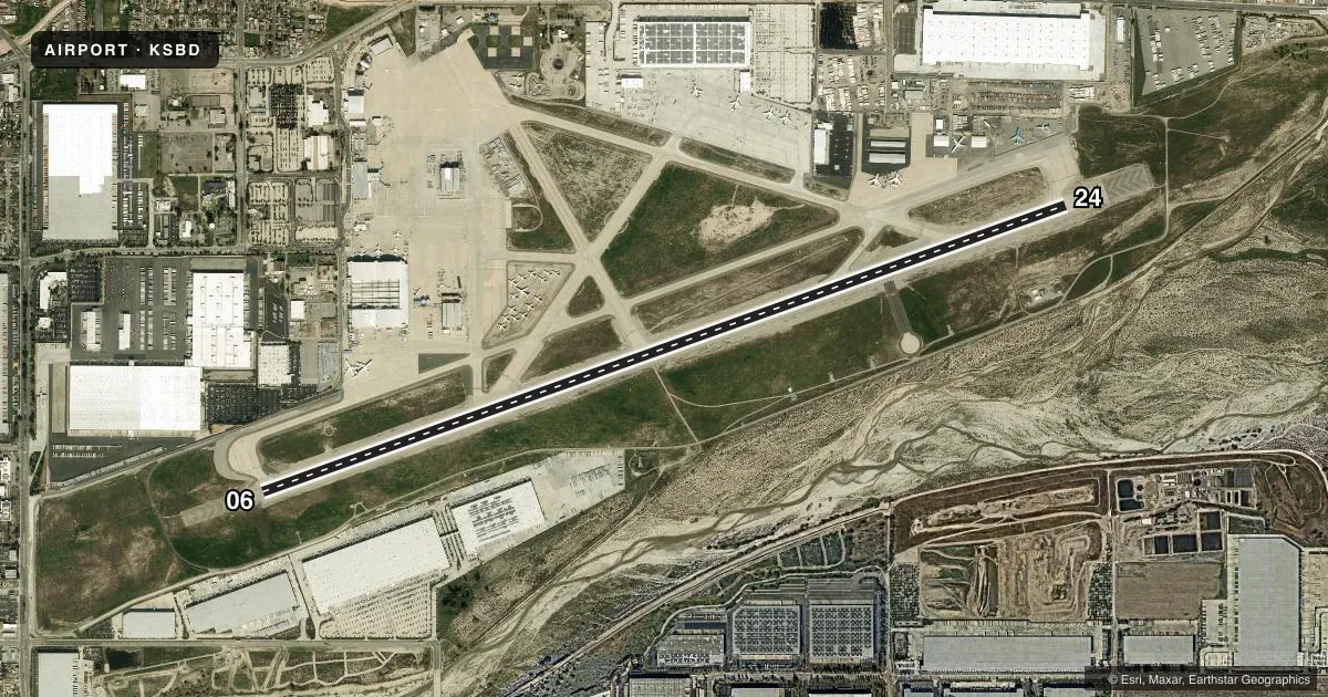
Runways & pattern
Full pagePattern entry · RWY 24
LEFT TRAFFICRunway end performance
| End | TORA | TODA | ASDA | LDA | VGSI | Approach lights | Obstruction |
|---|---|---|---|---|---|---|---|
| 06 | 10,000' | 10,000' | 10,000' | 10,000' | PAPI 4-box left(3°) | — | — |
| 24 | 10,000' | 10,000' | 10,000' | 10,000' | PAPI 4-box left(3°) | — | — |
Declared distances in feet. TORA = takeoff run available, TODA = takeoff distance, ASDA = accelerate-stop, LDA = landing distance.
Airport sketch
Runways drawn to scale from FAA survey coordinates, rendered over satellite imagery. Not for navigation.
Approaches & charts
ILS · 1
Services on the field
Fuel grades, oxygen, maintenance, ramp storage and lighting — as declared to the FAA by the airport operator.
Fuel & services
- Fuel
- 100LLA
- Oxygen (bulk)
- High pressure
- Airframe repair
- Major
- Power plant repair
- Major
- Other services
- AFRT,AVNCS,CARGO
Ramp & ground
- Transient storage
- Tie-down
- Landing fee
- Yes
- Customs
- Not available
- Lighting schedule
- SEE RMK
- Beacon schedule
- SS-SR
- Beacon
- White / Green (civil land)(WG)
- Wind indicator
- Lighted
- Segmented circle
- Yes
Fuel & FBOs
Cheapest 100LL and Jet A on the field and nearby. Always confirm with the FBO before taxi.
Airport notes
Surface conditions, obstructions, local procedures, lighting outages and other notes published with each FAA cycle.
General notes
- HIGH TERRAIN N AND E OF APT.
- RY 06 DESIGNATED CALM WIND RY.
- FIRE FIGHTING ACFT CTC US FOREST SVC TANKER BASE ON GND FREQ 123.975.
- RY 06/24 STRENGTH RATED FOR THE A380 AT 1,300,000 LBS.
- PERIODIC LIVE FIREFIGHTING TRAINING PRODUCING SMOKE AND LIGHT EMMISIONS APPROX 6,000 FT NE OF RY 6 THLD.
- ATCT NON VISIBLE AREA ON TWY ALPHA 425 FT WEST OF TWY ALPHA 1.
- AFTER HOURS GENERAL AVIATION ACCESS AND FUEL AVBL WITH PPR CALL FIXED BASE OPERATORS AT 909-382-6068.
- AIRFIELD SFC COND NOT MNT BTN THE HRS 2000-0500.
- TWY A, A1, E, ACFT WINGSPAN MORE THAN 171 FT USE INBOARD ENGS DRG TAX.
- FOR CD WHEN ATCT CLSD CTC SOCAL APCH AT 800-448-3724.
- REI ARPT 4.5 NM EAST TPA 2500 MSL CTAF/AUNICOM 123.05. AEROBATIC AREA 6.2 NM EAST 3800-7800 MSL. RMN VIGILANT TO SEE AND AVOID.
Lighting notes
- WHEN ATCT CLSD HIRL PRESET LOW INTST, TO INCREASE INTST AND ACTVT REILS RYS 06 & 24 ACTVT - CTAF. PAPI RYS 06 AND RY 24 OPER CONTINUOUSLY.
Runway surface & condition
- 06/24PCR VALUE: 1260/R/B/W/T
VFR map & nearby airports
VFR sectional. Tap any ICAO chip to open that airport.
Key facts · KSBD
Answer card- ICAO
- KSBD
- Name
- SAN BERNARDINO INTL
- Location
- SAN BERNARDINO, CALIFORNIA
- Elevation
- 1,159.3 ft MSL
- Traffic pattern altitude
- 1,959.3 ft MSL (800 AGL)
- Control tower
- Towered · 0700-2100
- Total runways
- 1
- Longest runway
- 06/24 · 10,000 ft
- Published ILS approaches
- 1
- Published frequencies
- 10
- Magnetic variation
- 13°
- Current flight rules
- VFR
- Current wind
- 240° at 11 kt
- Favored runway now
- RWY 24
San Bernardino Intl is in San Bernardino, California. Field elevation is 1,159.3 ft MSL. The airport has one runway. Runway 06/24 is 10,000 ft long with concrete pavement. The tower is open daily from 0700 to 2100. When the tower is closed, runway lights come up on CTAF. The runway end identifier lights on 06 and 24 can be activated on CTAF too. Precision approach path indicators on both runway ends operate continuously.
There is one ILS approach. It is for runway 06. Pattern altitude is 800 ft AGL, which is 1,959.3 ft MSL. Luxivair is on the field. It carries 100LL, Jet A and Jet A Prist. After hours, general aviation access and fuel are available with prior permission by calling the FBO. The airport notes high terrain north and east of the field. That matters on departure and arrival, especially if you are planning a low-altitude maneuvering profile.
The field sits in busy Southern California airspace. The published frequencies include SoCal Approach and Departure on 127.0. Class C is on 125.5. Runway 06 is the calm wind runway. Be alert for nearby traffic. Reid Hillview Airport is 4.5 NM east with its own pattern traffic. An aerobatic area is also 6.2 NM east. The airport surface is not maintained between 2000 and 0500. Plan taxi and parking with that in mind.