METAR & TAF KONT
Current METAR
Observed 01:53Z
KONT 270153Z 25012G19KT 10SM FEW100 FEW160 BKN230 33/17 A2988 RMK AO2 SLP096 T03280172 $
- Wind
- 250° @ 12G19 kt
- Visibility
- 10 SM
- Temp / Dew
- 33°C / 17°C
- Altimeter
- 29.88 inHg
- Clouds
- BKN
- Density alt
- 3,380 ft
- Ceiling
- 23,000 ft AGL
- Rules
- VFR
Airport info & contacts
Manager on record, flight service, ARTCC, attendance schedule and pattern altitude — published by the FAA and refreshed every 28 days.
Location
- From city
- 2 NM E
- VFR sectional
- LOS ANGELES
- ARTCC
- ZLA · LOS ANGELES
- NOTAM facility
- ONT (NOTAM-D)
Airport manager
- Name
- ATIF ELKADI
- Phone
- 909-544-5300
- Address
- 1923 EAST AVION STREET, ONTARIO CA 91761
Flight service · Hours
- FSS RAL
- RIVERSIDE1-800-WX-BRIEF
- Attendance
- ALL
Frequencies
Tap any row to copy the frequency to your clipboard.
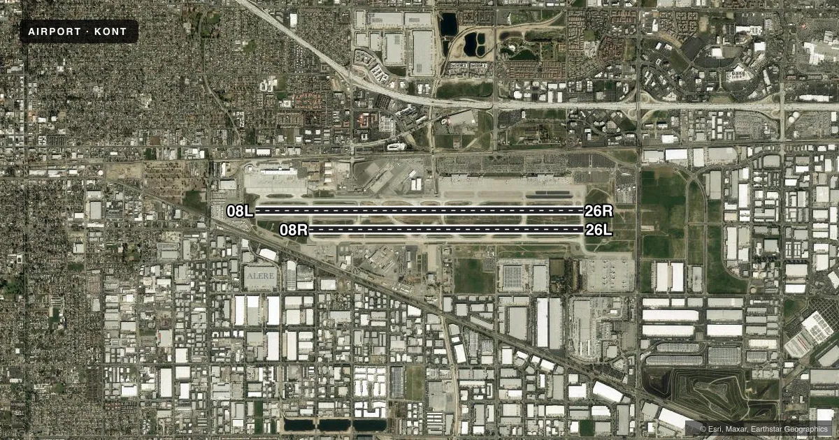
Runways & pattern
Full pagePattern entry · RWY 26R
RIGHT TRAFFIC| Runway | Heading (°M) | Length | Surface | Traffic |
|---|---|---|---|---|
| 08L/26RFavored | 78° / 258° | 12,197 ft | CONC | 26R R |
| 08R/26L | 78° / 258° | 10,200 ft | CONC | 08R R |
Runway end performance
| End | TORA | TODA | ASDA | LDA | VGSI | Approach lights | Obstruction |
|---|---|---|---|---|---|---|---|
| 08L | 12,197' | 12,197' | 12,197' | 11,200' | PAPI 4-box left(3°) | MALSR | 20', rr, 600' from thr, 250' R of cntrln, slope 20 |
| 26R | 12,197' | 12,197' | 12,197' | 12,197' | PAPI 4-box left(3°) | ALSF2 | 40', pole, 2050' from thr, 400' R of cntrln, slope 46 |
| 08R | 10,200' | 10,200' | 10,200' | 10,200' | PAPI 4-box left(3°) | — | — |
| 26L | 10,200' | 10,200' | 10,200' | 10,200' | PAPI 4-box right(3°) | ALSF2 | 40', pole, 2050' from thr, 400' R of cntrln, slope 46 |
Declared distances in feet. TORA = takeoff run available, TODA = takeoff distance, ASDA = accelerate-stop, LDA = landing distance.
Airport sketch
Runways drawn to scale from FAA survey coordinates, rendered over satellite imagery. Not for navigation.
Approaches & charts
ILS · 3
Services on the field
Fuel grades, oxygen, maintenance, ramp storage and lighting — as declared to the FAA by the airport operator.
Fuel & services
- Fuel
- 100LLA
- Oxygen (bottled)
- HIGH/LOW
- Oxygen (bulk)
- Not available
- Airframe repair
- Major
- Power plant repair
- Major
- Other services
- AFRT,AVNCS,CARGO,CHTR,SALES
Ramp & ground
- Transient storage
- Not published
- Landing fee
- No fee published
- Customs
- Not available
- Beacon schedule
- SS-SR
- Beacon
- White / Green (civil land)(WG)
- Wind indicator
- Lighted
- Segmented circle
- No
Fuel & FBOs
Cheapest 100LL and Jet A on the field and nearby. Always confirm with the FBO before taxi.
Airport notes
Surface conditions, obstructions, local procedures, lighting outages and other notes published with each FAA cycle.
General notes
- FBO ON FREQ 130.75.
- WILDLIFE HAZARD MGT PLAN IN EFFECT; POTENTIAL BIRD HAZARDS MAY EXIST ON AND INVOF ARPT; BE ALERT TO LARGE NUMBERS OF STARLINGS AND CROWS POSSIBLE ON APCH TO RY 26L AND RY 26R, HAWKS, EAGLES, FALCONS AND OWLS SPOTTED ON OCCASION.
- NOISE ABATEMENT PROCEDURES IN EFFECT; FULL-LENGTH TURBOJET DEP ENCOURAGED, NIGHTLY PREFERENTIAL RWY USAGE, 2200-0700.
- ACFT PRKG AND CONTR GND SVCS ARE LTD FOR UNSKED OPS. FOR SCHEDULING INFO CALL AIRFIELD OPS 909-544-5454.
- TWY Y EAST OF TWY W IS A NON-MOVEMENT AREA; ALL ACFT CTC RAMP CTL 131.325 FOR ACCESS.
- ALL MILITARY AND GENERAL AVIATION (FIXED OR ROTOR WING) ACFT OPS ARE RESTRICTED TO FBO FACILITIES WITH ADVANCE COORDINATION; OVERNIGHT TIEDOWN AND PARKING FEE.
- PTNS OF TWY S IN THE VCY OF TWY F ARE NOT VSB FM ATCT; PILOTS USE CTN ENTERING TWY F SOUTH OF TWY S.
- ACFT ACCESS TO TWY R FROM RWY 26R PROHIBITED
- TWY F SOUTH OF TWY S RSTRD TO ACFT WITH 117 FT WINGSPAN AND SMALLER. TWY F SOUTH OF RWY 26L RSTRD TO ACFT WITH 180 FT WINGSPAN.
Runway surface & condition
- 08L/26RPCR VALUE: 580/R/A/W/T
- 08R/26LPCR VALUE: 720/R/A/W/T
Approach & departure obstructions
- 08LAPCH RATIO 50:1 TO DSPLCD THR.
VFR map & nearby airports
VFR sectional. Tap any ICAO chip to open that airport.
Key facts · KONT
Answer card- ICAO
- KONT
- Name
- ONTARIO INTL
- Location
- ONTARIO, CALIFORNIA
- Elevation
- 944.1 ft MSL
- Traffic pattern altitude
- 1,944.1 ft MSL (1,000 AGL)
- Control tower
- Towered · 24
- Total runways
- 2
- Longest runway
- 08L/26R · 12,197 ft
- Published ILS approaches
- 3
- Published frequencies
- 20
- Magnetic variation
- 12°
- Current flight rules
- VFR
- Current wind
- 250° at 12 kt
- Favored runway now
- RWY 26R
Ontario Intl is in Ontario, California. Field elevation is 944.1 ft MSL. The airport has 2 runways. The longest is 08L/26R at 12,197 ft. The tower is open 24 hours. Three ILS approaches are published for 08L, 26L and 26R.
Pattern altitude is not published in the facts. Use 1,000 ft AGL for light piston traffic unless the current Chart Supplement says otherwise. The field sits under a busy Southern California environment. Expect a lot of traffic flow. Stay sharp on taxi instructions. A wildlife hazard plan is in effect. Bird activity has been reported near the 26L and 26R approach paths. Taxiway F has wingspan limits in some areas. Taxiway Y east of taxiway W is a non-movement area. Ramp control contact is required there on 131.325.
Guardian Jet Center is on the field. It carries 100LL, Jet A and Jet A Prist. The airport remarks also say unscheduled parking and contract ground services are limited. Military and general aviation fixed-wing or rotor-wing operations are restricted to FBO facilities with advance coordination. Nightly preferential runway use runs from 2200 to 0700. Check the current FAA Chart Supplement for any published noise or curfew restrictions before flying into the field.